Ofbyld:13-09-29-nordfriesisches-wattenmeer-RalfR-18a.jpg
Oarspronklik bestân (4.288 × 2.163 pixels, bestânsgrutte: 2,51 MB, MIME-type: image/jpeg)
Dit bestân komt fan Wikimedia Commons, en kin ek troch oare projekten brûkt wurde. De beskriuwing op syn bestânsside dêre wurdt hjirûnder werjûn.
Gearfetting
Beskriuwing13-09-29-nordfriesisches-wattenmeer-RalfR-18a.jpg |
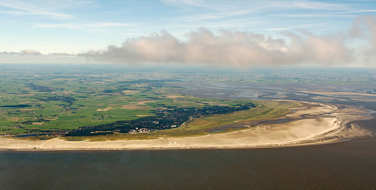
Deutsch: Fotoflug über das nordfriesische Wattenmeer; Blick aus 1200 m Höhe auf St. Peter-Ording
English: St-Peter-Ording; german North Sea |
|||||||||||||||||||||||
Datum | ||||||||||||||||||||||||
Boarne | Eigen wurk | |||||||||||||||||||||||
Auteur |
creator QS:P170,Q15080600
|
Camera location | 54° 19′ 32,89″ N, 8° 28′ 42,2″ E | View this and other nearby images on: OpenStreetMap | 54.325803; 8.478390 |
---|
Lisinsje
Der wurdt tastimming jûn ta kopiearjen, fersprieden en/of wizigjen fan dit dokumint ûnder de betinksten fan de GNU-lisinsje foar iepen dokumintaasje, ferzje 1.2, as eltse lettere ferzje útjûn troch de Free Software Foundation; sûnder Ynfariante Seksjes, sûnder Omkaftteksten foar de Foarkante en sûnder Omkaftteksten foar de Efterkante. In kopy fan de lisinsje is opnaam yn de seksje "Text of the GNU Free Documentation License".http://www.gnu.org/copyleft/fdl.htmlGFDLGNU Free Documentation Licensetruetrue |
- Fiel jo frij:
- te dielen – it wurk te kopiearjen, fersprieden en út te stjoeren
- te fermingen – it wurk oan te passen
- Under de neikommende betingsten:
- Nammefermelding – You must give appropriate credit, provide a link to the license, and indicate if changes were made. You may do so in any reasonable manner, but not in any way that suggests the licensor endorses you or your use.
- Lyk diele – If you remix, transform, or build upon the material, you must distribute your contributions under the same or compatible license as the original.
Ralf Roletschek
(1963–) |
|||
---|---|---|---|
Description | Dútsk civil engineer en fotograaf | ||
Bertedatum | 1963 | ||
Location of birth | Eberswalde | ||
Work period | from 1979 date QS:P,+1979-00-00T00:00:00Z/7,P580,+1979-00-00T00:00:00Z/9 | ||
Work location |
Barcelona, Wien, Eberswalde | ||
Authority file |
Dieses Foto entstand aufgrund eines Projektes, das von Wikimedia Deutschland e. V. gefördert wurde.
Im Rahmen des „Community-Projektbudgets“ sollen Luftbilder u.a. von Inseln, Halligen, Sanden und Küstenstädten der deutschen Nordseeküste angefertigt werden. Das Projekt „Fotoflüge“ wurde im September 2011 begonnen. |
This image has been assessed using the Quality image guidelines and is considered a Quality image.
العربية ∙ جازايرية ∙ беларуская ∙ беларуская (тарашкевіца) ∙ български ∙ বাংলা ∙ català ∙ čeština ∙ Cymraeg ∙ Deutsch ∙ Schweizer Hochdeutsch ∙ Zazaki ∙ Ελληνικά ∙ English ∙ Esperanto ∙ español ∙ eesti ∙ euskara ∙ فارسی ∙ suomi ∙ français ∙ galego ∙ עברית ∙ हिन्दी ∙ hrvatski ∙ magyar ∙ հայերեն ∙ Bahasa Indonesia ∙ italiano ∙ 日本語 ∙ Jawa ∙ ქართული ∙ 한국어 ∙ kurdî ∙ Lëtzebuergesch ∙ lietuvių ∙ македонски ∙ മലയാളം ∙ मराठी ∙ Bahasa Melayu ∙ Nederlands ∙ Norfuk / Pitkern ∙ polski ∙ português ∙ português do Brasil ∙ rumantsch ∙ română ∙ русский ∙ sicilianu ∙ slovenčina ∙ slovenščina ∙ shqip ∙ српски / srpski ∙ svenska ∙ தமிழ் ∙ తెలుగు ∙ ไทย ∙ Tagalog ∙ Türkçe ∙ toki pona ∙ українська ∙ vèneto ∙ Tiếng Việt ∙ 中文 ∙ 中文(简体) ∙ 中文(繁體) ∙ +/− |
Items portrayed in this file
depicts Ingelsk
copyright status Ingelsk
copyrighted Ingelsk
copyright license Ingelsk
Commons quality assessment Ingelsk
Wikimedia Commons quality image Ingelsk
source of file Ingelsk
original creation by uploader Ingelsk
coordinates of the point of view Ingelsk
54°19'32.89199"N, 8°28'42.20400"E
inception Ingelsk
29 sep 2013
captured with Ingelsk
Nikon D300S Ingelsk
sponsor Ingelsk
Wikimedia Austria Ingelsk
MIME type Ingelsk
image/jpeg
checksum Ingelsk
4ad65648f44f225c55d9fb1c24a0f977f1de50af
data size Ingelsk
2.635.606 byte
height Ingelsk
2.163 pixel
width Ingelsk
4.288 pixel
Triemskiednis
Klik op in datum/tiid om it bestân te besjen sa't it op dat stuit wie.
Datum/Tiid | Miniatuer | ôfmjittings | Meidogger | Opmerking | |
---|---|---|---|---|---|
lêste | 4 okt 2013, 12.14 | 4.288 × 2.163 (2,51 MB) | Ralf Roletschek |
Bestânsgebrûk
De neikommende side brûkt dit bestân:
Globaal bestânsgebrûk
De neikommende oare wiki's brûke dit bestân:
- Gebrûk op ca.wikipedia.org
- Gebrûk op de.wikipedia.org
- Gebrûk op en.wikipedia.org
- Gebrûk op fa.wikipedia.org
- Gebrûk op fi.wikipedia.org
- Gebrûk op mk.wikipedia.org
- Gebrûk op pl.wikipedia.org
Metadata
Dit bestân befettet oanfoljende ynformaasje, dy't troch in fotokamera, scanner of fotobewurkingsprogramma tafoege wêze kin. As it bestân oanpast is, komme de details mûglik net folslein oerien mei de feroare ôfbylding.
Kameramakker | NIKON CORPORATION |
---|---|
Kameramodel | NIKON D300S |
Auteur | Ralf Roletschek |
Auteursrjochthawwer |
|
Exposure time | 1/400 sek. (0,0025) |
Diafragmagetal | f/10 |
ISO speed rating | 200 |
Datum/tiid byldobjekt | 29 sep 2013, 13.51 |
Lens focal length | 32 mm |
Brûkersopmerkings | Foto by Marcela |
Breedtegraad | 54° 19′ 32,89″ N |
Lingtegraad | 8° 28′ 42,2″ E |
Hichte | 1.235 meters above sea level |
Breedte | 4.288 px |
Hichte | 2.848 px |
Bits per component |
|
Pixel composition | RGB |
Oriïntaasje | Normaal |
Oantal komponinten | 3 |
Horizontale resolúsje | 300 dpi |
Fertikale resolúsje | 300 dpi |
Brûkte programmatuer | Adobe Photoshop CS5.1 Windows |
Datum/tiid bestânswiziging | 4 okt 2013, 12.01 |
Y and C positioning | Centered |
Pair of black and white reference values |
|
Exposure Program | Normaal programma |
Exif-ferzje | 2.21 |
Datum/tiid digitalisearjen | 29 sep 2013, 13.51 |
APEX-slutertiid | 8,643856 |
APEX-apertuer | 6,643856 |
APEX exposure bias | 0 |
Maximum land aperture | 3 APEX (f/2,83) |
Metering mode | Center weighted average |
Ljochtboarne | Unbekend |
Flits | Flash did not fire |
Subsekonden bestânswiziging | 10 |
Subsekonden byldobjekt | 33 |
Subsekonden digitalisearjen | 33 |
Kleurromte | Uncalibrated |
Sensing method | One-chip color area sensor |
Bestânsboarne | Digital still camera |
Scene type | A directly photographed image |
Custom image processing | Normale ferwurking |
Exposure mode | Auto exposure |
Wytbalâns | Auto white balance |
Digital zoom ratio | 1 |
Focal length in 35 mm film | 48 mm |
Scene capture type | Standert |
Scene control | Gjint |
Kontrast | Normaal |
Sêding | Normaal |
Skerpens | Normaal |
Subject distance range | Unbekend |
GPS-tiid (atoomklok) | 12.51 |
Satellites used for measurement | 11 |
Reference for direction of image | Magnetic direction |
Direction of image | 41,47 |
Geodetic survey data used | WGS 84 |
GPS-datum | 29 sep 2013 |
GPS tag version | 0.0.2.2 |
Date metadata was last modified | 4 okt 2013, 14.01 |
Unique ID of original document | FB54A7F77581D62D3B207C6089228690 |
IIM-ferzje | 32.074 |