Ofbyld:Easter Island map-nl.svg

Size of this PNG preview of this SVG file: 800 × 569 piksels. Oare resolúsjes: 320 × 228 piksels | 640 × 455 piksels | 1.024 × 729 piksels | 1.280 × 911 piksels | 2.560 × 1.821 piksels | 1.750 × 1.245 piksels.
Oarspronklik bestân (SVG-bestân, nominaal 1.750 × 1.245 pixels, bestânsgrutte: 535 KB)
Gearfetting
| Beskriuwing |
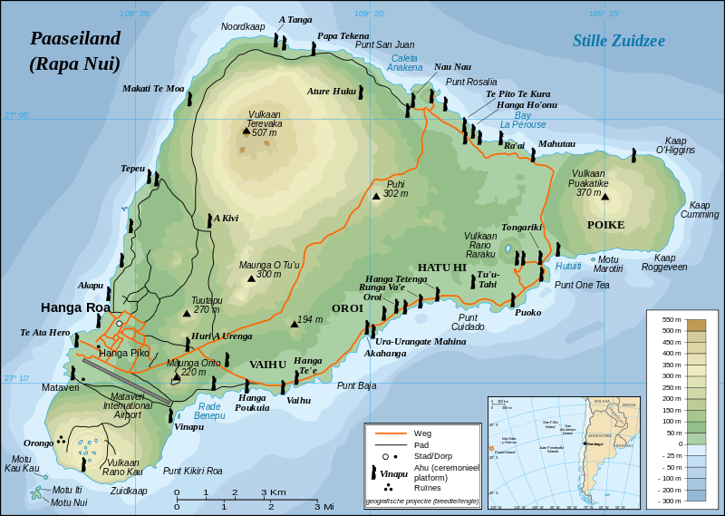
English: Detailed topographic map in Dutch of Easter Island
Français : Carte topographique détaillée en Néerlandais de l'île de Paques
Nederlands: Topografische kaart van Paaseiland
Português: Mapa topográfico detalhado, em Neerlandesa, da Ilha da Páscoa. |
| Datum | |
| Boarne |
Own work, translation of Image:Easter Island map-fr.svg Background and elevation reference maps : topographic map (IGM map ?) and CIA map Ahu names (ceremonial platforms with moai) : prof. William Mulloy's map (easier to read here) and [1] Locator reference map : National Geographic |
| Auteur | Eric Gaba (Sting), vertaald door Stuntelaar |
| Tastimming (Reusing this file) |
Creative Commons : share alike - attribution required |
| Oare ferzjes |
[]
|


![[1]](http://www.waymarker.co.uk/ml/rapanui/map.jpg)
This W3C-unspecified vector image was created with Inkscape .

|
This SVG file contains embedded text that can be translated into your language, using any capable SVG editor, text editor or the SVG Translate tool. For more information see: About translating SVG files. |
Lisinsje
I, the copyright holder of this work, hereby publish it under the following license:
This file is licensed under the Creative Commons Attribution-Share Alike 2.5 Generic license.
- Fiel jo frij:
- te dielen – it wurk te kopiearjen, fersprieden en út te stjoeren
- te fermingen – it wurk oan te passen
- Under de neikommende betingsten:
- Nammefermelding – You must give appropriate credit, provide a link to the license, and indicate if changes were made. You may do so in any reasonable manner, but not in any way that suggests the licensor endorses you or your use.
- Lyk diele – If you remix, transform, or build upon the material, you must distribute your contributions under the same or compatible license as the original.
Triemskiednis
Klik op in datum/tiid om it bestân te besjen sa't it op dat stuit wie.
| Datum/Tiid | Miniatuer | ôfmjittings | Meidogger | Opmerking | |
|---|---|---|---|---|---|
| lêste | 22 apr 2008, 21.10 | | 1.750 × 1.245 (535 KB) | Stuntelaar~commonswiki | == Samenvatting == {{Featured picture}} {{Information| |Description={{en|Detailed topographic map in Dutch of Easter Island}} {{fr|Carte topographique détaillée en Néerlandais de l'île de Paques}} {{nl|Topo |
Bestânsgebrûk
De neikommende 2 siden brûke dit bestân:
Globaal bestânsgebrûk
De neikommende oare wiki's brûke dit bestân:
- Gebrûk op af.wikipedia.org
- Gebrûk op fo.wikipedia.org
- Gebrûk op nl.wikipedia.org
- Gebrûk op nl.wikivoyage.org