Ofbyld:Fens-OMC.jpg
Gjin hegere resolúsje beskikber.
Fens-OMC.jpg (514 × 432 pixels, bestânsgrutte: 45 KB, MIME-type: image/jpeg)

|
Ofbyld:Map of the Fens.svg is in fektorferzje fan dizze triem. As net fan sljochtere kwaliteit tsjinnet dizze brûkt te wurden yn plak fan dizze rasterôfbylding.
File:Fens-OMC.jpg → File:Map of the Fens.svg
Sjoch Help:SVG foar mear ynformaasje. |
 |
Gearfetting
| Beskriuwing |
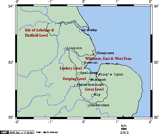
English: A rough map of the Fens in Eastern England |
| Datum | |
| Boarne | created using Online Map Creation, http://www.aquarius.geomar.de/omc/omc_intro.html, and altered (to include rough borders or the Fens) by myself. |
| Auteur | Jb? |
Source requires cc-by-sa copyright; license altered. Magog the Ogre (talk) 20:17, 24 December 2010 (UTC)
Lisinsje
This file is licensed under the Creative Commons Attribution-Share Alike 2.5 Generic license.
- Fiel jo frij:
- te dielen – it wurk te kopiearjen, fersprieden en út te stjoeren
- te fermingen – it wurk oan te passen
- Under de neikommende betingsten:
- Nammefermelding – You must give appropriate credit, provide a link to the license, and indicate if changes were made. You may do so in any reasonable manner, but not in any way that suggests the licensor endorses you or your use.
- Lyk diele – If you remix, transform, or build upon the material, you must distribute your contributions under the same or compatible license as the original.
Triemskiednis
Klik op in datum/tiid om it bestân te besjen sa't it op dat stuit wie.
| Datum/Tiid | Miniatuer | ôfmjittings | Meidogger | Opmerking | |
|---|---|---|---|---|---|
| lêste | 4 des 2006, 18.47 | | 514 × 432 (45 KB) | Jb? | A rough map of the Fens in Eastern England. Public Domain - created using Online Map Creation, http://www.aquarius.geomar.de/omc/omc_intro.html, and altered (to include rough borders or the Fens) by myself. |
Bestânsgebrûk
De neikommende side brûkt dit bestân:
Globaal bestânsgebrûk
De neikommende oare wiki's brûke dit bestân:
- Gebrûk op be.wikipedia.org
- Gebrûk op fa.wikipedia.org
- Gebrûk op fr.wikipedia.org
- Gebrûk op hr.wikipedia.org
- Gebrûk op hy.wikipedia.org
- Gebrûk op id.wikipedia.org
- Gebrûk op ja.wikipedia.org
- Gebrûk op nl.wikipedia.org
- Gebrûk op pl.wikipedia.org
- Gebrûk op ru.wikipedia.org
- Gebrûk op sh.wikipedia.org
- Gebrûk op uk.wikipedia.org
- Gebrûk op www.wikidata.org