Ofbyld:Franks expansion.gif

Franks_expansion.gif (790 × 505 pixels, bestânsgrutte: 64 KB, MIME-type: image/gif, looped, 17 frames, 21 s)
Farankowie
Gearfetting
| Beskriuwing |
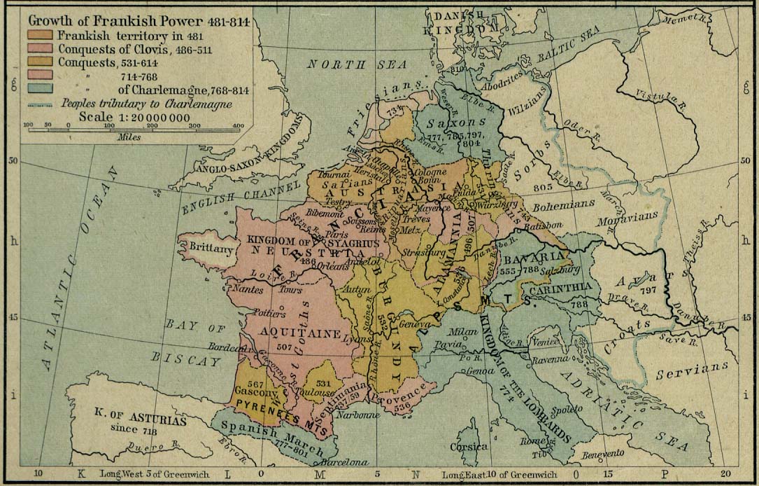
Expansion of the Franks, using Library of Texas Frankish power map, Image:843-870 Europe.jpg and Image:Western empire verdun 843.png. (Simplified for the purposes of the animation - Franks were not united in some periods; at many points they had different kings - frankish dominions shown at Image:ClovisDomain.jpg) Note only shows saxony after it was completely subdued (804) although most sources say range (772-98 for instance); some maps show brittany controlled by franks. Based on blank map of Europe from commons |
| Datum | 22 desimber 2006 (original upload date) |
| Boarne | Geen machineleesbare bron opgegeven. Eigen werk aangenomen (gebaseerd op auteursrechtclaims). |
| Auteur | Geen machineleesbare auteur aanwezig. Op basis van auteursrechtclaims wordt auteur Roke~commonswiki aangenomen. |
Lisinsje

|
Der wurdt tastimming jûn ta kopiearjen, fersprieden en/of wizigjen fan dit dokumint ûnder de betinksten fan de GNU-lisinsje foar iepen dokumintaasje, ferzje 1.2, as eltse lettere ferzje útjûn troch de Free Software Foundation; sûnder Ynfariante Seksjes, sûnder Omkaftteksten foar de Foarkante en sûnder Omkaftteksten foar de Efterkante. In kopy fan de lisinsje is opnaam yn de seksje "Text of the GNU Free Documentation License". |
| This file is licensed under the Creative Commons Attribution-Share Alike 3.0 Unported license. | ||
| ||
| This licensing tag was added to this file as part of the GFDL licensing update. |
Triemskiednis
Klik op in datum/tiid om it bestân te besjen sa't it op dat stuit wie.
| Datum/Tiid | Miniatuer | ôfmjittings | Meidogger | Opmerking | |
|---|---|---|---|---|---|
| lêste | 12 okt 2009, 00.01 | | 790 × 505 (64 KB) | YemeniteCamel | I did a mistake, now it's fine. |
| 11 okt 2009, 21.38 |  | 790 × 505 (69 KB) | YemeniteCamel | increase font size | |
| 22 des 2006, 15.50 |  | 790 × 505 (44 KB) | Roke~commonswiki | Expansion of the Franks, using [http://www.lib.utexas.edu/maps/historical/shepherd/frankish_power_481_814.jpg Library of Texas Frankish power map], Image:843-870 Europe.jpg and Image:Western empire verdun 843.png. (Simplified for the purposes |
Bestânsgebrûk
De neikommende side brûkt dit bestân:
Globaal bestânsgebrûk
De neikommende oare wiki's brûke dit bestân:
- Gebrûk op af.wikipedia.org
- Gebrûk op an.wikipedia.org
- Gebrûk op ar.wikipedia.org
- Gebrûk op arz.wikipedia.org
- Gebrûk op ast.wikipedia.org
- Gebrûk op azb.wikipedia.org
- Gebrûk op az.wikipedia.org
- Gebrûk op ba.wikipedia.org
- Gebrûk op be-tarask.wikipedia.org
- Gebrûk op be.wikipedia.org
- Gebrûk op bg.wikipedia.org
- Gebrûk op br.wikipedia.org
- Gebrûk op bs.wikipedia.org
- Gebrûk op bxr.wikipedia.org
- Gebrûk op ca.wikipedia.org
- Gebrûk op cs.wikipedia.org
- Gebrûk op cv.wikipedia.org
- Gebrûk op cy.wikipedia.org
- Gebrûk op de.wikipedia.org
- Gebrûk op el.wikipedia.org
- Gebrûk op en.wikipedia.org
Mear globaal gebrûk fan dit bestân besjen.