Ofbyld:Locator map NB 2011 in Germany.svg

Size of this PNG preview of this SVG file: 506 × 600 piksels. Oare resolúsjes: 202 × 240 piksels | 405 × 480 piksels | 648 × 768 piksels | 864 × 1.024 piksels | 1.728 × 2.048 piksels | 1.073 × 1.272 piksels.
Oarspronklik bestân (SVG-bestân, nominaal 1.073 × 1.272 pixels, bestânsgrutte: 886 KB)
Gearfetting
.svg)
.svg)
.svg)
.svg)
.svg)
.svg)
.svg)

-en.svg)

.svg)
.svg)
.svg)

_(US48).svg)
_(small_islands_magnified)_(-mini_map_-rivers).svg)
.svg)
_(extra_close)_(US48).svg)
.svg)
_(zoom).svg)

.svg)


_(UNMIK).svg)
.svg)
_(disputed_hatched).svg)
_(claimed_and_disputed_hatched).svg)
.svg)
.svg)
_(%2Ball_claims_hatched).svg)

.svg)
_(shade).svg)
_(shade)_(special_marker).svg)
_(-mini_map).svg)
_(-mini_map).svg)
_(-mini_map).svg)


.svg)

.svg)
Lisinsje
I, the copyright holder of this work, hereby publish it under the following licenses:

|
Der wurdt tastimming jûn ta kopiearjen, fersprieden en/of wizigjen fan dit dokumint ûnder de betinksten fan de GNU-lisinsje foar iepen dokumintaasje, ferzje 1.2, as eltse lettere ferzje útjûn troch de Free Software Foundation; sûnder Ynfariante Seksjes, sûnder Omkaftteksten foar de Foarkante en sûnder Omkaftteksten foar de Efterkante. In kopy fan de lisinsje is opnaam yn de seksje "Text of the GNU Free Documentation License". |
This file is licensed under the Creative Commons Attribution-Share Alike 3.0 Unported, 2.5 Generic, 2.0 Generic and 1.0 Generic license.
- Fiel jo frij:
- te dielen – it wurk te kopiearjen, fersprieden en út te stjoeren
- te fermingen – it wurk oan te passen
- Under de neikommende betingsten:
- Nammefermelding – You must give appropriate credit, provide a link to the license, and indicate if changes were made. You may do so in any reasonable manner, but not in any way that suggests the licensor endorses you or your use.
- Lyk diele – If you remix, transform, or build upon the material, you must distribute your contributions under the same or compatible license as the original.
You may select the license of your choice.
Triemskiednis
Klik op in datum/tiid om it bestân te besjen sa't it op dat stuit wie.
| Datum/Tiid | Miniatuer | ôfmjittings | Meidogger | Opmerking | |
|---|---|---|---|---|---|
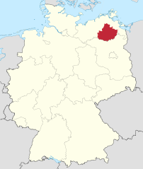
| lêste | 15 des 2010, 14.33 | | 1.073 × 1.272 (886 KB) | TUBS | =={{int:filedesc}}== {{Information |Description= {{de|Lage von Landkreis Mecklenburgische Seenplatte in Mecklenburg-Vorpommern, Deutschland nach der Kreisgebietsreform 2011.}} {{en|Locator map of Landkrei |
Bestânsgebrûk
De neikommende side brûkt dit bestân:
Globaal bestânsgebrûk
De neikommende oare wiki's brûke dit bestân:
- Gebrûk op cs.wikipedia.org
- Gebrûk op da.wikipedia.org
- Gebrûk op de.wikipedia.org
- Gebrûk op eo.wikipedia.org
- Gebrûk op fi.wikipedia.org
- Gebrûk op frr.wikipedia.org
- Gebrûk op fr.wikipedia.org
- Gebrûk op hu.wikipedia.org
- Gebrûk op it.wikipedia.org
- Gebrûk op ja.wikipedia.org
- Gebrûk op lv.wikipedia.org
- Gebrûk op nl.wikipedia.org
- Gebrûk op pl.wikipedia.org
- Gebrûk op pnb.wikipedia.org
- Gebrûk op sv.wikipedia.org
- Gebrûk op uk.wikipedia.org