Ofbyld:Moody County South Dakota Incorporated and Unincorporated areas Flandreau Highlighted.svg

Size of this PNG preview of this SVG file: 799 × 329 piksels. Oare resolúsjes: 320 × 132 piksels | 640 × 264 piksels | 1.024 × 422 piksels | 1.280 × 527 piksels | 2.560 × 1.054 piksels | 850 × 350 piksels.
Oarspronklik bestân (SVG-bestân, nominaal 850 × 350 pixels, bestânsgrutte: 79 KB)
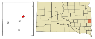
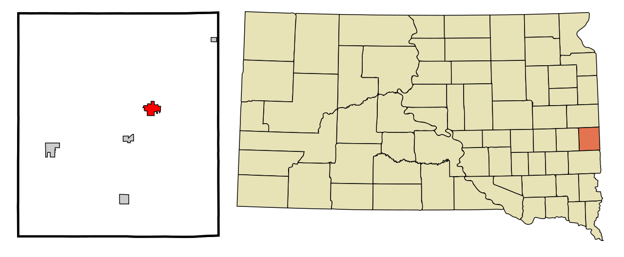
| Beskriuwing | This map shows the incorporated and unincorporated areas in Moody County, South Dakota, highlighting Flandreau in red. It was created with a custom script with US Census Bureau data and modified with Inkscape. |
| Datum | |
| Boarne | My own work, based on public domain information. Based on similar map concepts by Ixnayonthetimmay |
| Auteur | Arkyan |
I, the copyright holder of this work, hereby publish it under the following licenses:

|
Der wurdt tastimming jûn ta kopiearjen, fersprieden en/of wizigjen fan dit dokumint ûnder de betinksten fan de GNU-lisinsje foar iepen dokumintaasje, ferzje 1.2, as eltse lettere ferzje útjûn troch de Free Software Foundation; sûnder Ynfariante Seksjes, sûnder Omkaftteksten foar de Foarkante en sûnder Omkaftteksten foar de Efterkante. In kopy fan de lisinsje is opnaam yn de seksje "Text of the GNU Free Documentation License". |
| This file is licensed under the Creative Commons Attribution-Share Alike 3.0 Unported license. | ||
| ||
| This licensing tag was added to this file as part of the GFDL licensing update. |
This file is licensed under the Creative Commons Attribution-Share Alike 2.5 Generic, 2.0 Generic and 1.0 Generic license.
- Fiel jo frij:
- te dielen – it wurk te kopiearjen, fersprieden en út te stjoeren
- te fermingen – it wurk oan te passen
- Under de neikommende betingsten:
- Nammefermelding – You must give appropriate credit, provide a link to the license, and indicate if changes were made. You may do so in any reasonable manner, but not in any way that suggests the licensor endorses you or your use.
- Lyk diele – If you remix, transform, or build upon the material, you must distribute your contributions under the same or compatible license as the original.
You may select the license of your choice.
Triemskiednis
Klik op in datum/tiid om it bestân te besjen sa't it op dat stuit wie.
| Datum/Tiid | Miniatuer | ôfmjittings | Meidogger | Opmerking | |
|---|---|---|---|---|---|
| lêste | 28 aug 2007, 00.05 | 850 × 350 (79 KB) | ArkyBot~commonswiki | {{Information |Description=This map shows the incorporated and unincorporated areas in Moody County, South Dakota, highlighting Flandreau in re |
Bestânsgebrûk
De neikommende side brûkt dit bestân:
Globaal bestânsgebrûk
De neikommende oare wiki's brûke dit bestân:
- Gebrûk op ar.wikipedia.org
- Gebrûk op arz.wikipedia.org
- Gebrûk op azb.wikipedia.org
- Gebrûk op ca.wikipedia.org
- Gebrûk op ceb.wikipedia.org
- Gebrûk op de.wikipedia.org
- Gebrûk op en.wikipedia.org
- Gebrûk op eu.wikipedia.org
- Gebrûk op fa.wikipedia.org
- Gebrûk op fr.wikipedia.org
- Gebrûk op ht.wikipedia.org
- Gebrûk op hu.wikipedia.org
- Gebrûk op it.wikipedia.org
- Gebrûk op sh.wikipedia.org
- Gebrûk op simple.wikipedia.org
- Gebrûk op sr.wikipedia.org
- Gebrûk op tt.wikipedia.org
- Gebrûk op ur.wikipedia.org
- Gebrûk op www.wikidata.org
- Gebrûk op zh-min-nan.wikipedia.org
- Gebrûk op zh.wikipedia.org