Ofbyld:Ruhr area-administration.png

Grutte fan dit proefbyld: 800 × 474 piksels. Oare resolúsjes: 320 × 190 piksels | 640 × 380 piksels | 1.000 × 593 piksels.
Oarspronklik bestân (1.000 × 593 pixels, bestânsgrutte: 72 KB, MIME-type: image/png)

|
This locator map image could be re-created using vector graphics as an SVG file. This has several advantages; see Commons:Media for cleanup for more information. If an SVG form of this image is available, please upload it and afterwards replace this template with
{{vector version available|new image name}}.
It is recommended to name the SVG file “Ruhr area-administration.svg”—then the template Vector version available (or Vva) does not need the new image name parameter. |
Gearfetting
| Beskriuwing |
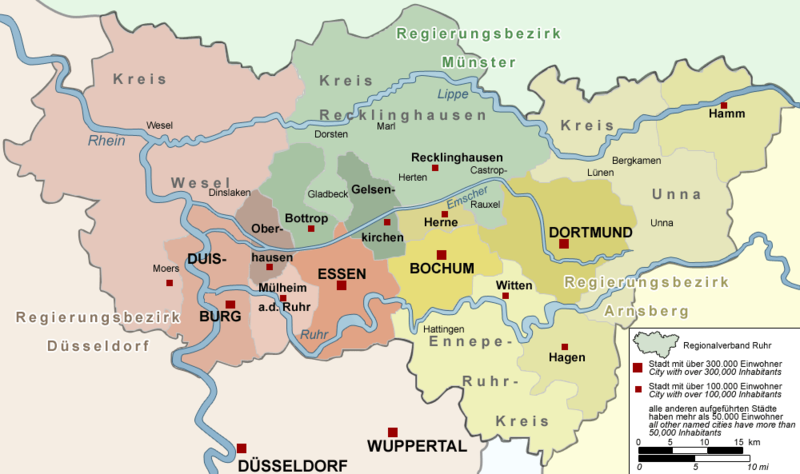
Deutsch: Karte der Verwaltung des Ruhrgebiets, Deutschland – Die Karte zeigt die Verwaltungsstruktur (Regierungsbezirke, Kreise/Kreisfreie Städte, Regionalverband Ruhr sowie allen Städte über 50.000 Einwohner) des Ruhrgebiets.
English: Map of the administration of the Ruhr area, Germany – The map shows the administration (Regierungsbezirke, cities/districts, Regionalverband Ruhr and all cities with more than 50,000 inhabitants) of the Ruhr Area, Germany. |
| Datum | |
| Boarne |
Eigen wurk Deutsch: von mir selbst, Threedots (Daniel Ullrich), mit Adobe Photoshop 6.0 „gezeichnet“; Datengrundlage: GeoDaten des Landesvermessungsamts NRW (damalige URL: www.ruhrgebiet.de/daten/geodatenserver.shtml) und verschiedene andere Karten
English: "drawn" by myself, Threedots (Daniel Ullrich), with Adobe Photoshop 6.0; used data set: official GeoData (former URL: www.ruhrgebiet.de/daten/geodatenserver.shtml) and several other maps |
| Auteur | Threedots (Daniel Ullrich) |
Lisinsje
Threedots (Daniel Ullrich), the copyright holder of this work, hereby publishes it under the following licenses:

|
Der wurdt tastimming jûn ta kopiearjen, fersprieden en/of wizigjen fan dit dokumint ûnder de betinksten fan de GNU-lisinsje foar iepen dokumintaasje, ferzje 1.2, as eltse lettere ferzje útjûn troch de Free Software Foundation; sûnder Ynfariante Seksjes, sûnder Omkaftteksten foar de Foarkante en sûnder Omkaftteksten foar de Efterkante. In kopy fan de lisinsje is opnaam yn de seksje "Text of the GNU Free Documentation License". |
| This file is licensed under the Creative Commons Attribution-Share Alike 3.0 Unported license. | ||
| Nammefermelding: Threedots (Daniel Ullrich) | ||
| ||
| This licensing tag was added to this file as part of the GFDL licensing update. |
This file is licensed under the Creative Commons Attribution-Share Alike 2.0 Germany license.
Nammefermelding: Threedots (Daniel Ullrich)
- Fiel jo frij:
- te dielen – it wurk te kopiearjen, fersprieden en út te stjoeren
- te fermingen – it wurk oan te passen
- Under de neikommende betingsten:
- Nammefermelding – You must give appropriate credit, provide a link to the license, and indicate if changes were made. You may do so in any reasonable manner, but not in any way that suggests the licensor endorses you or your use.
- Lyk diele – If you remix, transform, or build upon the material, you must distribute your contributions under the same or compatible license as the original.

You may select the license of your choice.
Triemskiednis
Klik op in datum/tiid om it bestân te besjen sa't it op dat stuit wie.
| Datum/Tiid | Miniatuer | ôfmjittings | Meidogger | Opmerking | |
|---|---|---|---|---|---|
| lêste | 4 sep 2007, 12.37 | | 1.000 × 593 (72 KB) | Hogenberg | |
| 4 jan 2006, 01.35 |  | 1.000 × 593 (79 KB) | Piedone | situation of Duisburg and Moers corrected | |
| 21 des 2004, 00.26 |  | 1.000 × 593 (79 KB) | Threedots | small changes (colors, yardstick etc.) | |
| 10 des 2004, 13.38 |  | 1.000 × 593 (78 KB) | Threedots | Map of the Administration of the Ruhr area, Germany | |
| 10 des 2004, 10.14 |  | 1.000 × 593 (79 KB) | Threedots | Map of the administration of the Ruhr area, Germany |
Bestânsgebrûk
De neikommende side brûkt dit bestân:
Globaal bestânsgebrûk
De neikommende oare wiki's brûke dit bestân:
- Gebrûk op az.wikipedia.org
- Gebrûk op bg.wikipedia.org
- Gebrûk op de.wikipedia.org
- Gebrûk op de.wikivoyage.org
- Gebrûk op en.wikipedia.org
- Gebrûk op eo.wikipedia.org
- Gebrûk op es.wikipedia.org
- Gebrûk op frr.wikipedia.org
- Gebrûk op hr.wikipedia.org
- Gebrûk op ia.wikipedia.org
- Gebrûk op id.wikipedia.org
- Gebrûk op ja.wikipedia.org
- Gebrûk op mk.wikipedia.org
- Gebrûk op nl.wikipedia.org
- Gebrûk op pt.wikipedia.org
- Gebrûk op sh.wikipedia.org
- Gebrûk op sl.wikipedia.org
- Gebrûk op stq.wikipedia.org
- Gebrûk op sv.wikipedia.org
- Gebrûk op th.wikipedia.org
- Gebrûk op tr.wikipedia.org
- Gebrûk op www.wikidata.org
- Gebrûk op xmf.wikipedia.org