Ofbyld:South Carolina population map.png
Gjin hegere resolúsje beskikber.
South_Carolina_population_map.png (600 × 600 pixels, bestânsgrutte: 198 KB, MIME-type: image/png)
| Beskriuwing |
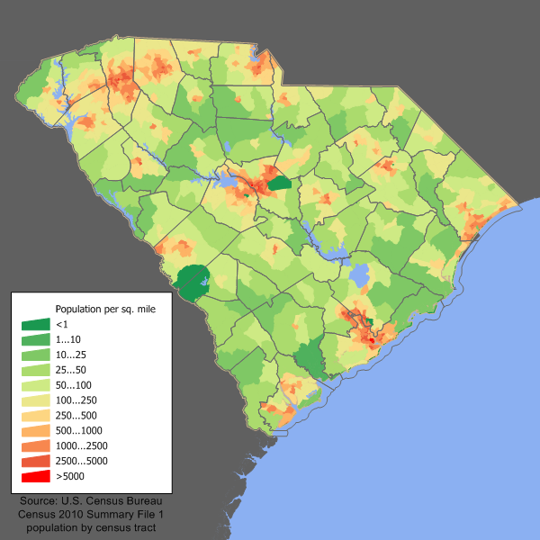
English: South Carolina population density map based on Census 2010. See the data lineage for a process description. |
||||||||
| Datum | 21 febrewaris 2006 (original upload date) | ||||||||
| Boarne | Transferred from en.wikipedia to Commons by Spyder_Monkey using CommonsHelper. | ||||||||
| Auteur | JimIrwin at Ingelsk Wikipedy | ||||||||
| Tastimming (Reusing this file) |
I, the copyright holder of this work, hereby publish it under the following license:
|

Original upload log
The original description page was here. All following user names refer to en.wikipedia.
- 2006-02-21 18:35 JimIrwin 700×525× (45112 bytes) South Carolina population density map based on Census 2000. See the [[User:JimIrwin/Lineage_of_population_maps|data lineage]] for a process description.
Triemskiednis
Klik op in datum/tiid om it bestân te besjen sa't it op dat stuit wie.
| Datum/Tiid | Miniatuer | ôfmjittings | Meidogger | Opmerking | |
|---|---|---|---|---|---|
| lêste | 11 des 2011, 16.33 | | 600 × 600 (198 KB) | JimIrwin | 2010 census update |
| 9 aug 2010, 04.30 |  | 700 × 525 (44 KB) | File Upload Bot (Magnus Manske) | {{BotMoveToCommons|en.wikipedia|year={{subst:CURRENTYEAR}}|month={{subst:CURRENTMONTHNAME}}|day={{subst:CURRENTDAY}}}} {{Information |Description={{en| South Carolina population density map based on Census 2000. See the [[:en:User:JimIrwin/Lineage_of_po |
Bestânsgebrûk
De neikommende side brûkt dit bestân:
Globaal bestânsgebrûk
De neikommende oare wiki's brûke dit bestân:
- Gebrûk op de.wikipedia.org
- Gebrûk op en.wikipedia.org
- Gebrûk op fr.wikipedia.org
- Gebrûk op he.wikipedia.org
- Gebrûk op hu.wikipedia.org
- Gebrûk op incubator.wikimedia.org
- Gebrûk op kn.wikipedia.org
- Gebrûk op pl.wikipedia.org
- Gebrûk op ro.wikipedia.org