Ofbyld:Suva.jpg
Grutte fan dit proefbyld: 800 × 600 piksels. Oare resolúsjes: 320 × 240 piksels | 640 × 480 piksels | 1.024 × 768 piksels.
Oarspronklik bestân (1.024 × 768 pixels, bestânsgrutte: 395 KB, MIME-type: image/jpeg)
Gearfetting
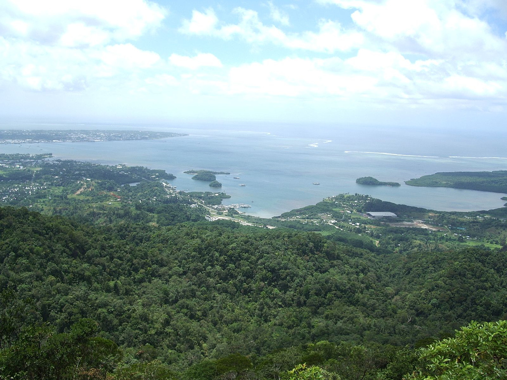
| Beskriuwing | Suva harbour as seen from the highest peak in the area. |
| Datum | |
| Boarne | Suva harbour |
| Auteur | Jared Wiltshire |
| Camera location | | View this and other nearby images on: OpenStreetMap |
|---|
Lisinsje
This file is licensed under the Creative Commons Attribution 2.0 Generic license.
- Fiel jo frij:
- te dielen – it wurk te kopiearjen, fersprieden en út te stjoeren
- te fermingen – it wurk oan te passen
- Under de neikommende betingsten:
- Nammefermelding – You must give appropriate credit, provide a link to the license, and indicate if changes were made. You may do so in any reasonable manner, but not in any way that suggests the licensor endorses you or your use.
| This image was originally posted to Flickr by jaredw_1986 at https://www.flickr.com/photos/40988322@N00/102993549. It was reviewed on 31 oktober 2009 by FlickreviewR and was confirmed to be licensed under the terms of the cc-by-2.0. |
Triemskiednis
Klik op in datum/tiid om it bestân te besjen sa't it op dat stuit wie.
| Datum/Tiid | Miniatuer | ôfmjittings | Meidogger | Opmerking | |
|---|---|---|---|---|---|
| lêste | 15 okt 2009, 01.49 | | 1.024 × 768 (395 KB) | Martin H. | Image from http://www.flickr.com/photos/jaredw_1986/102993549/ to replace the previous uploaded non-free image |
Bestânsgebrûk
De neikommende side brûkt dit bestân:
Globaal bestânsgebrûk
De neikommende oare wiki's brûke dit bestân:
- Gebrûk op ast.wikipedia.org
- Gebrûk op be-tarask.wikipedia.org
- Gebrûk op bs.wikipedia.org
- Gebrûk op cs.wikipedia.org
- Gebrûk op de.wikipedia.org
- Gebrûk op el.wikipedia.org
- Gebrûk op en.wikipedia.org
- Gebrûk op en.wikiversity.org
- Gebrûk op eo.wikipedia.org
- Gebrûk op es.wikipedia.org
- Gebrûk op fa.wikipedia.org
- Gebrûk op fj.wikipedia.org
- Gebrûk op gl.wikipedia.org
- Gebrûk op he.wikipedia.org
- Gebrûk op he.wikivoyage.org
- Gebrûk op hif.wikipedia.org
- Gebrûk op hi.wikipedia.org
- Gebrûk op ht.wikipedia.org
- Gebrûk op ka.wikipedia.org
- Gebrûk op mk.wikipedia.org
- Gebrûk op ms.wikipedia.org
- Gebrûk op mt.wikipedia.org
- Gebrûk op nl.wikipedia.org
- Gebrûk op nn.wikipedia.org
- Gebrûk op pl.wiktionary.org
- Gebrûk op ps.wikipedia.org
- Gebrûk op sah.wikipedia.org
- Gebrûk op sr.wikipedia.org
- Gebrûk op sv.wikipedia.org
- Gebrûk op th.wikipedia.org
- Gebrûk op tr.wikipedia.org
- Gebrûk op uk.wikipedia.org
- Gebrûk op zh-min-nan.wikipedia.org