Ofbyld:USA territorial growth.gif

Grutte fan dit proefbyld: 800 × 498 piksels. Oare resolúsjes: 320 × 199 piksels | 640 × 398 piksels | 921 × 573 piksels.
Oarspronklik bestân (921 × 573 pixels, bestânsgrutte: 2,01 MB, MIME-type: image/gif, looped, 10 frames, 50 s)
Gearfetting
| Beskriuwing |
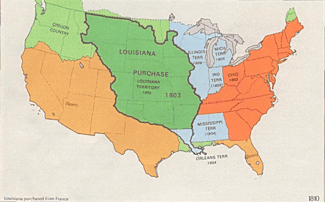
English: US territorial growth 1810–1920, based on the PD USGS maps in Category:Territorial growth maps of the United States.
See key below for explanation of colors.  |
||||||
| Boarne |
|
||||||
| Auteur |
|
||||||
| Oare ferzjes |
|

Lisinsje
This image is in the public domain in the United States because it only contains materials that originally came from the United States Geological Survey, an agency of the United States Department of the Interior. For more information, see the official USGS copyright policy.
|
Triemskiednis
Klik op in datum/tiid om it bestân te besjen sa't it op dat stuit wie.
| Datum/Tiid | Miniatuer | ôfmjittings | Meidogger | Opmerking | |
|---|---|---|---|---|---|
| lêste | 31 mai 2006, 03.39 | | 921 × 573 (2,01 MB) | Roke~commonswiki | longer interval, 3 seconds --> 5 seconds |
| 30 mai 2006, 14.21 |  | 921 × 573 (2,67 MB) | Roke~commonswiki | US territorial growth 1810-1920, based on the USGS maps in commons:Category:USA Territorial Growth Maps, put together in Corel Painter IX. The individual maps have this licence: {{PD-USGov-USGS}} If it is necessary for me to licence my contributio |
Bestânsgebrûk
De neikommende 2 siden brûke dit bestân:
Globaal bestânsgebrûk
De neikommende oare wiki's brûke dit bestân:
- Gebrûk op bn.wikipedia.org
- Gebrûk op en.wikipedia.org
- Gebrûk op es.wikipedia.org
- Gebrûk op fa.wikipedia.org
- Gebrûk op ha.wikipedia.org
- Gebrûk op he.wikipedia.org
- Gebrûk op nl.wikipedia.org
- Gebrûk op pnb.wikipedia.org
- Gebrûk op ru.wikipedia.org
- Gebrûk op ru.wikinews.org
- Gebrûk op sr.wikipedia.org
- Gebrûk op tr.wikipedia.org
- Gebrûk op ur.wikipedia.org
- Gebrûk op uz.wikipedia.org
- Gebrûk op www.wikidata.org