Ofbyld:Armenian distribution map.png
Grutte fan dit proefbyld: 800 × 392 piksels. Oare resolúsjes: 320 × 157 piksels | 640 × 314 piksels | 1.024 × 502 piksels | 1.880 × 921 piksels.
Oarspronklik bestân (1.880 × 921 pixels, bestânsgrutte: 90 KB, MIME-type: image/png)

|
This demographic map image could be re-created using vector graphics as an SVG file. This has several advantages; see Commons:Media for cleanup for more information. If an SVG form of this image is available, please upload it and afterwards replace this template with
{{vector version available|new image name}}.
It is recommended to name the SVG file “Armenian distribution map.svg”—then the template Vector version available (or Vva) does not need the new image name parameter. |
Gearfetting
| Beskriuwing |
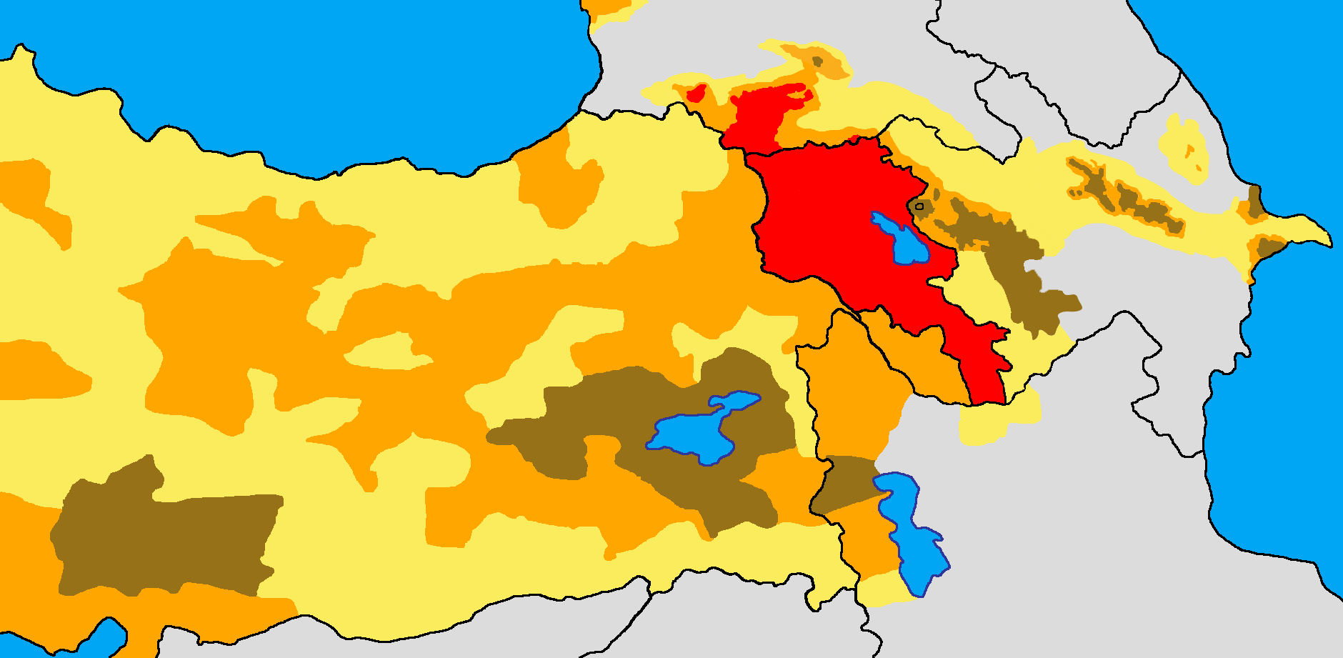
English: Historical and modern distribution of Armenians.
Settlement areas of Armenians in early 21st century.
Settlement areas of Armenians in early 20th century. More than 50% 25-50% Less than 25%
Works used:
|
| Datum | |
| Boarne | Eigen wurk |
| Auteur | Yerevanci |
.jpg)
Lisinsje
I, the copyright holder of this work, hereby publish it under the following license:
This file is licensed under the Creative Commons Attribution-Share Alike 3.0 Unported license.
- Fiel jo frij:
- te dielen – it wurk te kopiearjen, fersprieden en út te stjoeren
- te fermingen – it wurk oan te passen
- Under de neikommende betingsten:
- Nammefermelding – You must give appropriate credit, provide a link to the license, and indicate if changes were made. You may do so in any reasonable manner, but not in any way that suggests the licensor endorses you or your use.
- Lyk diele – If you remix, transform, or build upon the material, you must distribute your contributions under the same or compatible license as the original.
Triemskiednis
Klik op in datum/tiid om it bestân te besjen sa't it op dat stuit wie.
| Datum/Tiid | Miniatuer | ôfmjittings | Meidogger | Opmerking | |
|---|---|---|---|---|---|
| lêste | 17 apr 2024, 21.00 | | 1.880 × 921 (90 KB) | Golden | updated Karabakh and corrected Aghdam area, as well as Tartar/Barda area. These areas did not have any significant Armenian precense |
| 19 sep 2023, 17.33 |  | 1.880 × 921 (89 KB) | Norschweden | Added fomer occupied teritorry as less then 25% area as there were some armenians living there, just not many | |
| 23 nov 2022, 23.33 |  | 1.880 × 921 (90 KB) | Golden | updating karabakh/artsakh following 2020 war | |
| 20 nov 2022, 12.32 |  | 1.880 × 921 (89 KB) | Antondimak | Reverted to version as of 14:51, 16 April 2016 (UTC) Last version, probably accidentally, removed Western part of map. | |
| 2 jan 2021, 06.31 |  | 1.742 × 920 (83 KB) | Randam | No reason to distinguish unofficial region | |
| 16 apr 2016, 16.51 |  | 1.880 × 921 (89 KB) | Yerevantsi | Reverted to version as of 17:00, 3 October 2014 (UTC) | |
| 19 sep 2015, 21.12 |  | 1.880 × 921 (80 KB) | Ercwlff | Armenians were not living on modern Georgian territory in the beginning of XX century. They were settled in Javakheti instead of Mekhetian Turks | |
| 3 okt 2014, 19.00 |  | 1.880 × 921 (89 KB) | Gardmanahay | Փոփոխությունները կատարվել են Ս.Կարապետյանի բանահավաք աշխատանքի արդյունքում ստեղծված տեղեկատվության հիման վրա: | |
| 3 jan 2014, 16.00 |  | 1.880 × 921 (61 KB) | Gardmanahay | Ավելացված են Ադրբեջանի և մասսամբ էլ Վրաստանի տարածքում բնակվող հայկական բնակավայրերը: | |
| 3 jan 2014, 15.56 |  | 1.880 × 921 (61 KB) | Gardmanahay | Ավելացված են Ադրբեջանի և մասսամբ էլ Վրաստանի տարածքում բնակվող հայկական բնակավայրերը: |
Bestânsgebrûk
De neikommende side brûkt dit bestân:
Globaal bestânsgebrûk
De neikommende oare wiki's brûke dit bestân:
- Gebrûk op azb.wikipedia.org
- Gebrûk op cs.wikipedia.org
- Gebrûk op da.wikipedia.org
- Gebrûk op de.wikipedia.org
- Gebrûk op en.wikipedia.org
- Gebrûk op gl.wikipedia.org
- Gebrûk op he.wikipedia.org
- Gebrûk op hu.wikipedia.org
- Gebrûk op hy.wikipedia.org
- Gebrûk op id.wikipedia.org
- Gebrûk op kk.wikipedia.org
- Gebrûk op la.wikipedia.org
- Gebrûk op lb.wikipedia.org
- Gebrûk op nl.wikipedia.org
- Gebrûk op ro.wikipedia.org
- Gebrûk op ru.wikipedia.org
- Gebrûk op sl.wikipedia.org
- Gebrûk op tr.wikipedia.org
- Gebrûk op uk.wikipedia.org