Ofbyld:Austin circuit.svg

Oarspronklik bestân (SVG-bestân, nominaal 2.300 × 2.300 pixels, bestânsgrutte: 104 KB)
Gearfetting
| Beskriuwing |
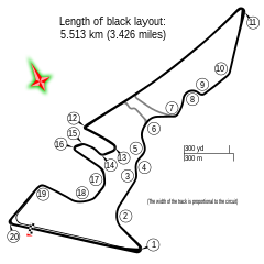
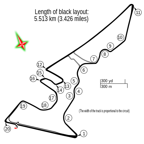
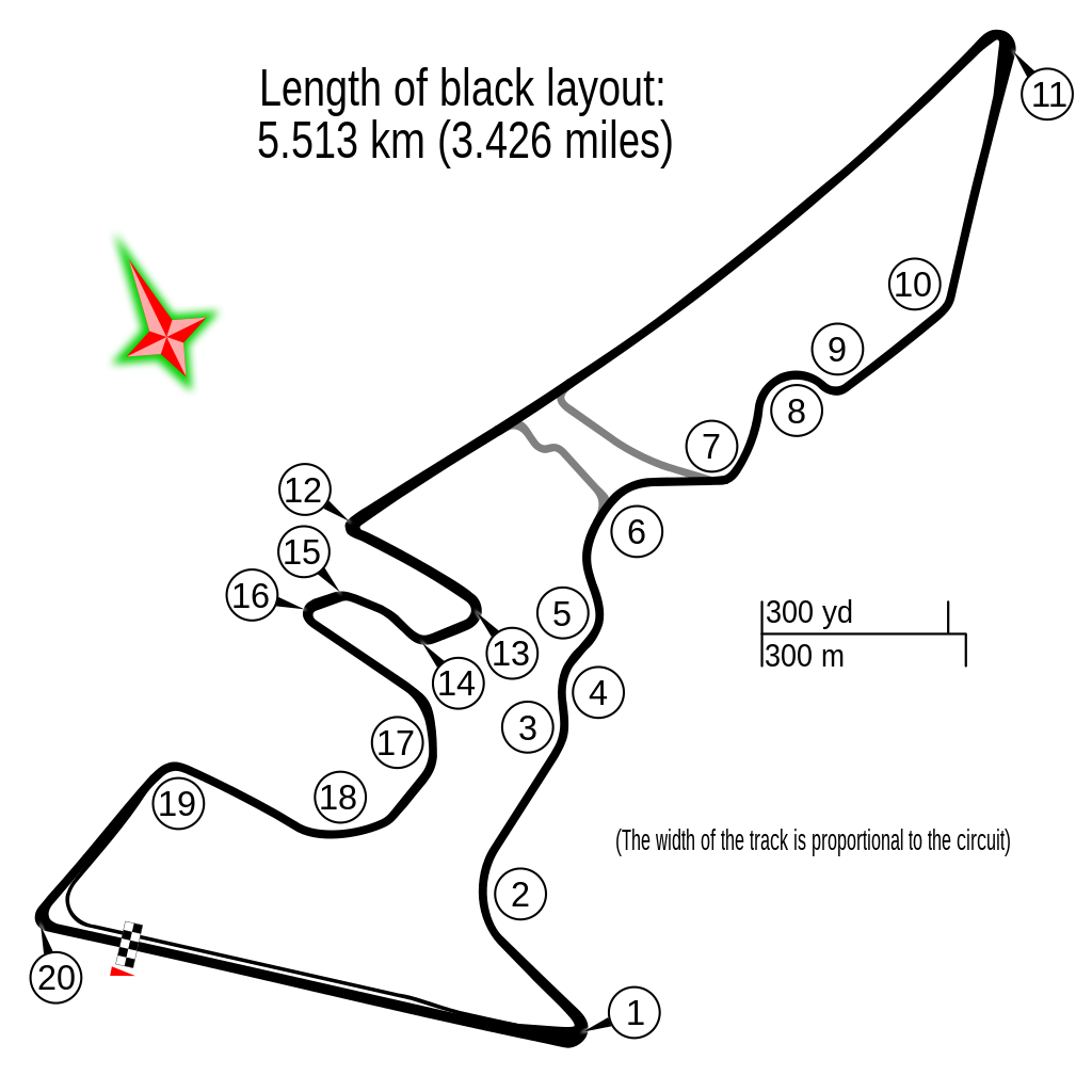
English: Circuit Austin |
| Datum | |
| Boarne | Eigen wurk |
| Auteur |
Gustavo Girardelli This W3C-unspecified vector image was created with Inkscape . |
| Oare ferzjes |
|
.svg)
| Description |
Deze kaart is gemaakt op basis van OpenStreetMap projectgegevens, verzameld door de gemeenschap. Deze kaart kan onvolledig zijn en fouten bevatten. Vertrouw er niet op voor navigatie. |
|||
| Datum | (geschiedenis bestand) | |||
| Boarne | openstreetmap.org | |||
| Makker |
OpenStreetMap bijdragers |
|||
| Tastimming (Reusing this file) |
OpenStreetMap-gegevens zijn beschikbaar onder de Open Database Licentie (details). Kaarttegels zijn gelicentieerd onder de Creative Commons Attribution-ShareAlike 2.0-licentie (CC-BY-SA 2.0).
This file is licensed under the Creative Commons Attribution-Share Alike 2.0 Generic license.
|
|||
| Georeferencing | If inappropriate please set warp_status = skip to hide. |
| Camera location | | View this and other nearby images on: OpenStreetMap |
|---|
Triemskiednis
Klik op in datum/tiid om it bestân te besjen sa't it op dat stuit wie.
| Datum/Tiid | Miniatuer | ôfmjittings | Meidogger | Opmerking | |
|---|---|---|---|---|---|
| lêste | 27 apr 2022, 12.06 | | 2.300 × 2.300 (104 KB) | DeFacto | Replaced "mi" with "miles" as that abbreviation is not in common use, especially in British English |
| 24 okt 2017, 14.19 |  | 2.300 × 2.300 (103 KB) | Cherkash | decimal point instead of comma | |
| 22 okt 2017, 08.10 |  | 2.300 × 2.300 (103 KB) | Cherkash | removed a strange artifact in rendering | |
| 22 okt 2017, 07.56 |  | 2.300 × 2.300 (103 KB) | Cherkash | fixed length, removed unnecessary text | |
| 16 okt 2014, 08.29 |  | 2.300 × 2.300 (109 KB) | Gustavo Girardelli | User created page with UploadWizard |
Bestânsgebrûk
De neikommende 11 siden brûke dit bestân:
- Circuit of the Americas
- Grutte Priis Formule 1 fan de Feriene Steaten 2012
- Grutte Priis Formule 1 fan de Feriene Steaten 2013
- Grutte Priis Formule 1 fan de Feriene Steaten 2014
- Grutte Priis Formule 1 fan de Feriene Steaten 2015
- Grutte Priis Formule 1 fan de Feriene Steaten 2016
- Grutte Priis Formule 1 fan de Feriene Steaten 2017
- Grutte Priis Formule 1 fan de Feriene Steaten 2018
- Grutte Priis Formule 1 fan de Feriene Steaten 2019
- Grutte Priis Formule 1 fan de Feriene Steaten 2021
- Grutte Priis Formule 1 fan de Feriene Steaten 2022
Globaal bestânsgebrûk
De neikommende oare wiki's brûke dit bestân:
- Gebrûk op af.wikipedia.org
- Verenigde State Grand Prix
- Lys van Formule Een-bane
- Circuit of the Americas
- 2015 Verenigde State Grand Prix
- 2014 Verenigde State Grand Prix
- 2013 Verenigde State Grand Prix
- 2016 Verenigde State Grand Prix
- 2017 Verenigde State Grand Prix
- 2018 Verenigde State Grand Prix
- 2019 Verenigde State Grand Prix
- 2021 Verenigde State Grand Prix
- 2022 Verenigde State Grand Prix
- 2023 Verenigde State Grand Prix
- Gebrûk op ar.wikipedia.org
- حلبة الأمريكتين
- جائزة الولايات المتحدة الكبرى 2015
- جائزة الولايات المتحدة الكبرى 2014
- جائزة الولايات المتحدة الكبرى 2013
- جائزة الولايات المتحدة الكبرى 2017
- جائزة الولايات المتحدة الكبرى 2016
- جائزة الولايات المتحدة الكبرى 2018
- جائزة الولايات المتحدة الكبرى 2012
- جائزة الولايات المتحدة الكبرى 2019
- جائزة الولايات المتحدة الكبرى
- جائزة الولايات المتحدة الكبرى 2021
- جائزة الولايات المتحدة الكبرى 2022
- جائزة الولايات المتحدة الكبرى 2023
- Gebrûk op ast.wikipedia.org
- Gebrûk op bg.wikipedia.org
- Gebrûk op bn.wikipedia.org
- Gebrûk op br.wikipedia.org
- Gebrûk op bs.wikipedia.org
Mear globaal gebrûk fan dit bestân besjen.