Ofbyld:Barrage Malpasset 2007.jpg

Grutte fan dit proefbyld: 800 × 283 piksels. Oare resolúsjes: 320 × 113 piksels | 640 × 226 piksels | 1.600 × 566 piksels.
Oarspronklik bestân (1.600 × 566 pixels, bestânsgrutte: 678 KB, MIME-type: image/jpeg)
Gearfetting
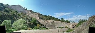
| Beskriuwing | Barrage de Malpasset Fréjus France destroyed on December 2, 1959 |
| Datum | |
| Boarne | Eigen wurk |
| Auteur | Bonho1962 |
| Camera location | | View this and other nearby images on: OpenStreetMap |
|---|
Lisinsje
| This work has been released into the public domain by its author, I, Bonho1962. This applies worldwide. In some countries this may not be legally possible; if so: I, Bonho1962 grants anyone the right to use this work for any purpose, without any conditions, unless such conditions are required by law. |
Triemskiednis
Klik op in datum/tiid om it bestân te besjen sa't it op dat stuit wie.
| Datum/Tiid | Miniatuer | ôfmjittings | Meidogger | Opmerking | |
|---|---|---|---|---|---|
| lêste | 11 jun 2007, 20.38 | 1.600 × 566 (678 KB) | Bonho1962 | {{Information |Description= |Source=self-made |Date= |Author= Bonho1962 }} |
Bestânsgebrûk
De neikommende side brûkt dit bestân:
Globaal bestânsgebrûk
De neikommende oare wiki's brûke dit bestân:
- Gebrûk op de.wikipedia.org
- Gebrûk op fr.wikipedia.org
- Gebrûk op he.wikipedia.org
- Gebrûk op ja.wikipedia.org
- Gebrûk op nl.wikipedia.org