Ofbyld:CSA states evolution.gif
Grutte fan dit proefbyld: 800 × 542 piksels. Oare resolúsjes: 320 × 217 piksels | 640 × 433 piksels | 1.000 × 677 piksels.
Oarspronklik bestân (1.000 × 677 pixels, bestânsgrutte: 245 KB, MIME-type: image/gif, looped, 38 frames, 1 min 53 s)
Gearfetting
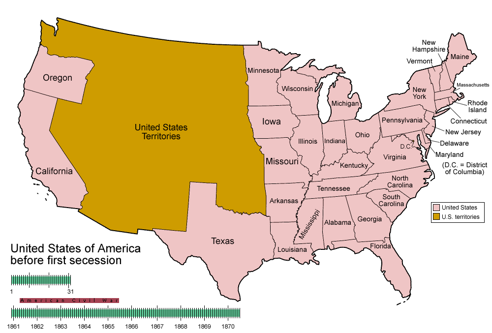
| Beskriuwing | Animated map/timeline of the territorial evolution of the Confederate States of America, from first secession to end of Reconstruction. |
| Datum | |
| Boarne | Eigen wurk |
| Auteur | User:Golbez |
|
Lisinsje
I, the copyright holder of this work, hereby publish it under the following licenses:

|
Der wurdt tastimming jûn ta kopiearjen, fersprieden en/of wizigjen fan dit dokumint ûnder de betinksten fan de GNU-lisinsje foar iepen dokumintaasje, ferzje 1.2, as eltse lettere ferzje útjûn troch de Free Software Foundation; sûnder Ynfariante Seksjes, sûnder Omkaftteksten foar de Foarkante en sûnder Omkaftteksten foar de Efterkante. In kopy fan de lisinsje is opnaam yn de seksje "Text of the GNU Free Documentation License". |
| This file is licensed under the Creative Commons Attribution-Share Alike 3.0 Unported license. | ||
| ||
| This licensing tag was added to this file as part of the GFDL licensing update. |
This file is licensed under the Creative Commons Attribution-Share Alike 2.5 Generic, 2.0 Generic and 1.0 Generic license.
- Fiel jo frij:
- te dielen – it wurk te kopiearjen, fersprieden en út te stjoeren
- te fermingen – it wurk oan te passen
- Under de neikommende betingsten:
- Nammefermelding – You must give appropriate credit, provide a link to the license, and indicate if changes were made. You may do so in any reasonable manner, but not in any way that suggests the licensor endorses you or your use.
- Lyk diele – If you remix, transform, or build upon the material, you must distribute your contributions under the same or compatible license as the original.
You may select the license of your choice.
Triemskiednis
Klik op in datum/tiid om it bestân te besjen sa't it op dat stuit wie.
| Datum/Tiid | Miniatuer | ôfmjittings | Meidogger | Opmerking | |
|---|---|---|---|---|---|
| lêste | 5 jun 2014, 07.30 | | 1.000 × 677 (245 KB) | RedXIV | Removed incorrect information. Kentucky and Missouri never seceded. The state governments of Kentucky and Missouri never voted to secede. Claiming that their secession actually happened gives an inaccurate impression of the actual sequence of events. |
| 21 des 2013, 12.56 |  | 1.000 × 677 (256 KB) | ChrisnHouston | I'm the one who broke the thumbnail. I'll try to fix it now... | |
| 20 des 2013, 15.38 |  | 1.000 × 677 (1,75 MB) | Afernand74 | No image displayed. Reupload to try to solve the problem | |
| 7 nov 2013, 13.33 |  | 1.000 × 677 (1,75 MB) | ChrisnHouston | Adding a bar to the timeline to indicate when the actual fighting of the Civil War happened, which is one of the most important aspects of this map. | |
| 11 apr 2012, 17.18 |  | 1.000 × 677 (254 KB) | Golbez | rv - er, MO and KY were indeed admitted to the CSA, though it lacked any control over them. why not go to the talk page for the CSA on enwp and chat about my next version? | |
| 10 apr 2012, 20.53 |  | 1.000 × 677 (225 KB) | Travürsa | Fixed errors. | |
| 18 nov 2007, 03.57 |  | 1.000 × 677 (254 KB) | Golbez | Removing frame of WV counties; that was incorrect, they were always part of WV | |
| 4 mrt 2007, 11.54 |  | 1.000 × 677 (259 KB) | Golbez | == Summary == {{Information |Description=Animated map/timeline of the territorial evolution of the Confederate States of America, from first secession to end of Reconstruction. |Source=Self-made. |Date=March 2007 |Author=User:Golbez |Permission= see b |
Bestânsgebrûk
De neikommende side brûkt dit bestân:
Globaal bestânsgebrûk
De neikommende oare wiki's brûke dit bestân:
- Gebrûk op af.wikipedia.org
- Gebrûk op bcl.wikipedia.org
- Gebrûk op cs.wikipedia.org
- Gebrûk op da.wikipedia.org
- Gebrûk op de.wikipedia.org
- Gebrûk op en.wikipedia.org
- Confederate States of America
- Portal:United States/Selected picture
- User talk:-asx-
- User talk:Golbez/Archive 2
- Portal:Maps/Selected picture
- Wikipedia:Featured picture candidates/March-2007
- Wikipedia:Picture peer review/CSA evolution
- Wikipedia:Featured picture candidates/CSA states evolution.gif
- Wikipedia:Wikipedia Signpost/2007-03-20/Features and admins
- Wikipedia:Wikipedia Signpost/2007-03-20/SPV
- Portal:Maps/Selected picture/11
- Portal:United States/Selected picture/15
- Wikipedia:Featured picture candidates/November-2009
- Wikipedia:Featured picture candidates/Non-Native American Nations Control over N America 1750-2008.gif
- Wikipedia:Featured picture candidates/delist/2010
- Wikipedia:Featured picture candidates/delist/File:CSA states evolution.gif
- User:TheVirginiaHistorian/sandbox
- Wikipedia:Village pump (technical)/Archive 110
- Wikipedia:Wikipedia Signpost/Single/2007-03-20
- Gebrûk op eo.wikipedia.org
- Gebrûk op eu.wikipedia.org
- Gebrûk op fr.wikipedia.org
- Gebrûk op fr.wiktionary.org
- Gebrûk op hr.wikipedia.org
- Gebrûk op hu.wikipedia.org
- Gebrûk op id.wikipedia.org
- Gebrûk op ja.wikipedia.org
- Gebrûk op la.wikipedia.org
- Gebrûk op ms.wikipedia.org
- Gebrûk op pt.wikipedia.org
- Gebrûk op ro.wikipedia.org
- Gebrûk op sr.wikipedia.org
- Gebrûk op th.wikipedia.org
- Gebrûk op tr.wikipedia.org
- Gebrûk op uk.wikipedia.org