Ofbyld:Carolingian empire 876.svg

Oarspronklik bestân(SVG-bestân, nominaal 1.091 × 1.053 pixels, bestânsgrutte: 149 KB)

Dit bestân komt fan Wikimedia Commons, en kin ek troch oare projekten brûkt wurde. De beskriuwing op syn bestânsside dêre wurdt hjirûnder werjûn.

Gearfetting

Beskriuwing
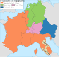
Español: Imperio carolingio de Carlos II el Calvo y división de Francia orientalis y División de Francia orientalis a la muerte de Luis el Germánico (876)
Datum
Boarne

Eigen wurk

  • [1]: 876 Death of Louis the German: east Francia divided between his sons (Karlmann of Bavaria, Louis the Younger of Franconia/Saxony, Charles the Fat of Alemannia and Alsace)
  • [2] Upon the death of Louis the German (876), east Francia was partitioned into three kingdoms: Bavaria went to Carlomann, the nothern sector plus Lotharingia went to Louis the Younger, and the southwestern portion, namely Alsace and Alemannia, was apportioned to Charles the Fat.
  • [3] King Louis, surnamed the German, had died in August of the year 876, leaving three sons. In the division of the kingdom, the southern and eastern privinces, collectively known by the name of Bavaria, were alloted to Carlmann, the elder of the princes; Charles, afterwards surnamed "the Fat", obtained Swabia, Alsace, and Transjurane Burgundy; and Louis, youngest, shared Eastern Franconia, Saony and a part of Lorraine.
  • [4] Charles appears to have received Alsace and the northern Burgundian pagi.
Auteur Trasamundo

Lisinsje

I, the copyright holder of this work, hereby publish it under the following licenses:
GNU head Der wurdt tastimming jûn ta kopiearjen, fersprieden en/of wizigjen fan dit dokumint ûnder de betinksten fan de GNU-lisinsje foar iepen dokumintaasje, ferzje 1.2, as eltse lettere ferzje útjûn troch de Free Software Foundation; sûnder Ynfariante Seksjes, sûnder Omkaftteksten foar de Foarkante en sûnder Omkaftteksten foar de Efterkante. In kopy fan de lisinsje is opnaam yn de seksje "Text of the GNU Free Documentation License".
w:fy:Creative Commons
Nammefermelding Lyk diele
This file is licensed under the Creative Commons Attribution-Share Alike 3.0 Unported, 2.5 Generic, 2.0 Generic and 1.0 Generic license.
Fiel jo frij:
  • te dielen – it wurk te kopiearjen, fersprieden en út te stjoeren
  • te fermingen – it wurk oan te passen
Under de neikommende betingsten:
  • Nammefermelding – You must give appropriate credit, provide a link to the license, and indicate if changes were made. You may do so in any reasonable manner, but not in any way that suggests the licensor endorses you or your use.
  • Lyk diele – If you remix, transform, or build upon the material, you must distribute your contributions under the same or compatible license as the original.
You may select the license of your choice.

Captions

Add a one-line explanation of what this file represents

Items portrayed in this file

depicts Ingelsk

copyrighted Ingelsk

inception Ingelsk

13 mrt 2010

MIME type Ingelsk

image/svg+xml

checksum Ingelsk

1d025827fed53c9f4d974f10a325ac86f6487086

determination method Ingelsk: SHA-1 Ingelsk

data size Ingelsk

152.407 byte

height Ingelsk

1.053 pixel

width Ingelsk

1.091 pixel

Triemskiednis

Klik op in datum/tiid om it bestân te besjen sa't it op dat stuit wie.

Datum/TiidMiniatuerôfmjittingsMeidoggerOpmerking
lêste1 sep 2016, 16.56Miniatuer foar de ferzje fan 1 sep 2016 om 16.561.091 × 1.053 (149 KB)Rowanwindwhistlerhttps://en.wikipedia.org/wiki/Wikipedia:WikiProject_Maps/Conventions http://colorbrewer2.org/#type=sequential&scheme=YlOrBr&n=5
14 mai 2010, 23.10Miniatuer foar de ferzje fan 14 mai 2010 om 23.101.091 × 1.053 (1,96 MB)TrasamundoCarlomán de Baviera
13 mrt 2010, 23.19Miniatuer foar de ferzje fan 13 mrt 2010 om 23.191.091 × 1.053 (1,96 MB)TrasamundoAlsace and northern Burgundian pagi to Charles the Fat
13 mrt 2010, 21.04Miniatuer foar de ferzje fan 13 mrt 2010 om 21.041.091 × 1.053 (1,89 MB)Trasamundolegend again
13 mrt 2010, 21.01Miniatuer foar de ferzje fan 13 mrt 2010 om 21.011.091 × 1.053 (1,89 MB)Trasamundolegend
13 mrt 2010, 20.57Miniatuer foar de ferzje fan 13 mrt 2010 om 20.571.091 × 1.053 (1,89 MB)Trasamundo{{Information |Description={{es|1=Imperio carolingio de Carlos II el Calvo}} |Source={{own}} |Author=Trasamundo |Date=13 March 2010 |Permission= |other_versions= }} Category:Maps of the Carolingian Empire

De neikommende side brûkt dit bestân:

Globaal bestânsgebrûk

De neikommende oare wiki's brûke dit bestân:

Metadata