Ofbyld:Cold war europe military alliances map en.png

Grutte fan dit proefbyld: 582 × 599 piksels. Oare resolúsjes: 233 × 240 piksels | 466 × 480 piksels | 746 × 768 piksels | 1.165 × 1.200 piksels.
Oarspronklik bestân (1.165 × 1.200 pixels, bestânsgrutte: 419 KB, MIME-type: image/png)

|
This military map image could be re-created using vector graphics as an SVG file. This has several advantages; see Commons:Media for cleanup for more information. If an SVG form of this image is available, please upload it and afterwards replace this template with
{{vector version available|new image name}}.
It is recommended to name the SVG file “Cold war europe military alliances map en.svg”—then the template Vector version available (or Vva) does not need the new image name parameter. |
Gearfetting
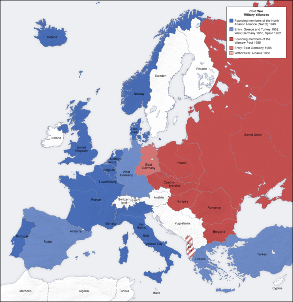
- Description: military alliances in the Cold war, map de
- Source: own map, based on the Generic Mapping Tools archive copy at the Wayback Machine and ETOPO2 archive copy at the Wayback Machine
- Author: San Jose, 7 October 2006
- Other versions: German, French, Classical Chinese, without text, Arabic
Lisinsje
The map has been created with the Generic Mapping Tools: https://www.generic-mapping-tools.org/ using one or more of these public-domain datasets for the relief:
|

|
Der wurdt tastimming jûn ta kopiearjen, fersprieden en/of wizigjen fan dit dokumint ûnder de betinksten fan de GNU-lisinsje foar iepen dokumintaasje, ferzje 1.2, as eltse lettere ferzje útjûn troch de Free Software Foundation; sûnder Ynfariante Seksjes, sûnder Omkaftteksten foar de Foarkante en sûnder Omkaftteksten foar de Efterkante. In kopy fan de lisinsje is opnaam yn de seksje "Text of the GNU Free Documentation License". |
| This file is licensed under the Creative Commons Attribution-Share Alike 3.0 Unported license. | ||
| ||
| This licensing tag was added to this file as part of the GFDL licensing update. |
See also
_en.png)
.png)
.jpg)
Triemskiednis
Klik op in datum/tiid om it bestân te besjen sa't it op dat stuit wie.
| Datum/Tiid | Miniatuer | ôfmjittings | Meidogger | Opmerking | |
|---|---|---|---|---|---|
| lêste | 20 mai 2012, 21.36 | | 1.165 × 1.200 (419 KB) | Patrickneil | Reverted to version as of 09:07, 12 June 2008, as requested on the Talk page |
| 11 apr 2010, 14.39 |  | 1.165 × 1.200 (415 KB) | IngerAlHaosului | fixed = west Berlin now light blue | |
| 12 jun 2008, 11.07 |  | 1.165 × 1.200 (419 KB) | San Jose | update | |
| 7 okt 2006, 16.55 |  | 1.165 × 1.200 (473 KB) | San Jose | upload |
Bestânsgebrûk
De neikommende 2 siden brûke dit bestân:
Globaal bestânsgebrûk
De neikommende oare wiki's brûke dit bestân:
- Gebrûk op af.wikipedia.org
- Gebrûk op ar.wikipedia.org
- Gebrûk op ast.wikipedia.org
- Gebrûk op azb.wikipedia.org
- Gebrûk op az.wikipedia.org
- Gebrûk op ba.wikipedia.org
- Gebrûk op be.wikipedia.org
- Gebrûk op bg.wikipedia.org
- Gebrûk op bs.wikipedia.org
- Gebrûk op ca.wikipedia.org
- Gebrûk op cs.wikipedia.org
- Gebrûk op cv.wikipedia.org
- Gebrûk op da.wikipedia.org
- Gebrûk op de.wikipedia.org
- Gebrûk op el.wikipedia.org
- Gebrûk op en.wikipedia.org
- Military alliance
- Cold War
- Foreign relations of the Soviet Union
- Bibliography of the Cold War
- Presidency of Harry S. Truman
- User:Aridd/Through the hidden door/Main
- User:Hires an editor/CWSandbox
- User:Eurocopter/Sandbox/Archive 1
- Khrushchev Thaw
- Foreign policy of the Harry S. Truman administration
- User:Falcaorib
- Gebrûk op eu.wikipedia.org
- Gebrûk op fa.wikipedia.org
- Gebrûk op fi.wikipedia.org
- Gebrûk op fr.wikipedia.org
- Gebrûk op gl.wikipedia.org
- Gebrûk op he.wikipedia.org
- Gebrûk op hif.wikipedia.org
- Gebrûk op ht.wikipedia.org
- Gebrûk op hy.wikipedia.org
- Gebrûk op id.wikipedia.org
- Gebrûk op it.wikipedia.org
Mear globaal gebrûk fan dit bestân besjen.