Ofbyld:Colonial empires in 1800.svg

Size of this PNG preview of this SVG file: 800 × 351 piksels. Oare resolúsjes: 320 × 140 piksels | 640 × 281 piksels | 1.024 × 449 piksels | 1.280 × 561 piksels | 2.560 × 1.123 piksels | 1.425 × 625 piksels.
Oarspronklik bestân (SVG-bestân, nominaal 1.425 × 625 pixels, bestânsgrutte: 228 KB)
Gearfetting
| Beskriuwing |
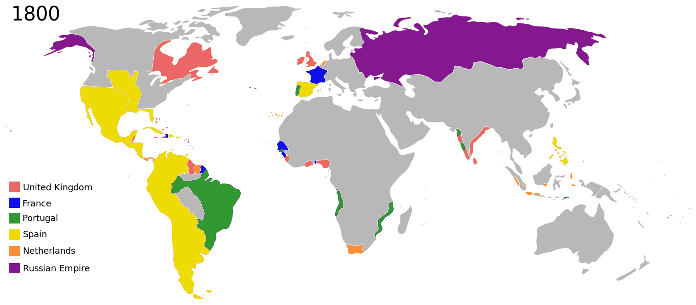
English: Colonial empires in 1800 |
| Datum | |
| Boarne |
|
| Auteur | George Tsiagalakis |
| Tastimming (Reusing this file) |
Please state licence(CC-BY-SA 4) and author when using this image |
| Oare ferzjes |
|
| Maps of world history | |
| BC | |
|
| |
| AD |
1 · 50 · 100 · 200 · 250 · 300 · 400 · 500 · 700 · 750 · 820 · 900 · 1200 · 1500 · 1556 · 1648 · 1700 · 1750 · 1815 · 1859 · 1871 · 1914 · 1989 · 2000 · |
|
Maps of colonization history | |
|
see also: Eastern Hemisphere only maps template (1300BC-1500AD) | |
| (this template: · view · discuss ) | |
.jpg)
._LOC_2001620596.jpg)
Lisinsje
I, the copyright holder of this work, hereby publish it under the following license:
This file is licensed under the Creative Commons Attribution-Share Alike 4.0 International license.
- Fiel jo frij:
- te dielen – it wurk te kopiearjen, fersprieden en út te stjoeren
- te fermingen – it wurk oan te passen
- Under de neikommende betingsten:
- Nammefermelding – You must give appropriate credit, provide a link to the license, and indicate if changes were made. You may do so in any reasonable manner, but not in any way that suggests the licensor endorses you or your use.
- Lyk diele – If you remix, transform, or build upon the material, you must distribute your contributions under the same or compatible license as the original.
| This is a retouched picture, which means that it has been digitally altered from its original version. The original can be viewed here: Colonisation 1800.png:
|
| Annotations | This image is annotated: View the annotations at Commons |
Triemskiednis
Klik op in datum/tiid om it bestân te besjen sa't it op dat stuit wie.
| Datum/Tiid | Miniatuer | ôfmjittings | Meidogger | Opmerking | |
|---|---|---|---|---|---|
| lêste | 27 okt 2023, 23.01 | | 1.425 × 625 (228 KB) | Johshh | File uploaded using svgtranslate tool (https://svgtranslate.toolforge.org/). Added translation for nb. |
| 18 mrt 2022, 01.56 |  | 1.425 × 625 (226 KB) | M.Bitton | per https://commons.wikimedia.org/w/index.php?title=Commons:Graphic_Lab/Map_workshop&oldid=640501111#Wrong_borders | |
| 2 nov 2014, 01.40 |  | 1.425 × 625 (398 KB) | Gts-tg | User created page with UploadWizard |
Bestânsgebrûk
De neikommende side brûkt dit bestân:
Globaal bestânsgebrûk
De neikommende oare wiki's brûke dit bestân:
- Gebrûk op af.wikipedia.org
- Gebrûk op ar.wikipedia.org
- Gebrûk op bn.wikipedia.org
- Gebrûk op bs.wikipedia.org
- Gebrûk op da.wikipedia.org
- Gebrûk op de.wikipedia.org
- Gebrûk op en.wikipedia.org
- Gebrûk op en.wikiversity.org
- Gebrûk op eu.wikipedia.org
- Gebrûk op fa.wikipedia.org
- Gebrûk op fr.wikipedia.org
- Gebrûk op ga.wikipedia.org
- Gebrûk op ja.wikipedia.org
- Gebrûk op mg.wikipedia.org
- Gebrûk op no.wikipedia.org
- Gebrûk op oc.wikipedia.org
- Gebrûk op pt.wikipedia.org
- Gebrûk op tr.wikipedia.org
- Gebrûk op uk.wikipedia.org
- Gebrûk op vi.wikipedia.org
- Gebrûk op www.wikidata.org
- Gebrûk op zh.wikipedia.org