Ofbyld:Crac des chevaliers syria.jpeg
Grutte fan dit proefbyld: 800 × 312 piksels. Oare resolúsjes: 320 × 125 piksels | 640 × 250 piksels | 1.024 × 399 piksels | 1.280 × 499 piksels | 4.015 × 1.566 piksels.
Oarspronklik bestân (4.015 × 1.566 pixels, bestânsgrutte: 4,41 MB, MIME-type: image/jpeg)
Gearfetting
| Beskriuwing |
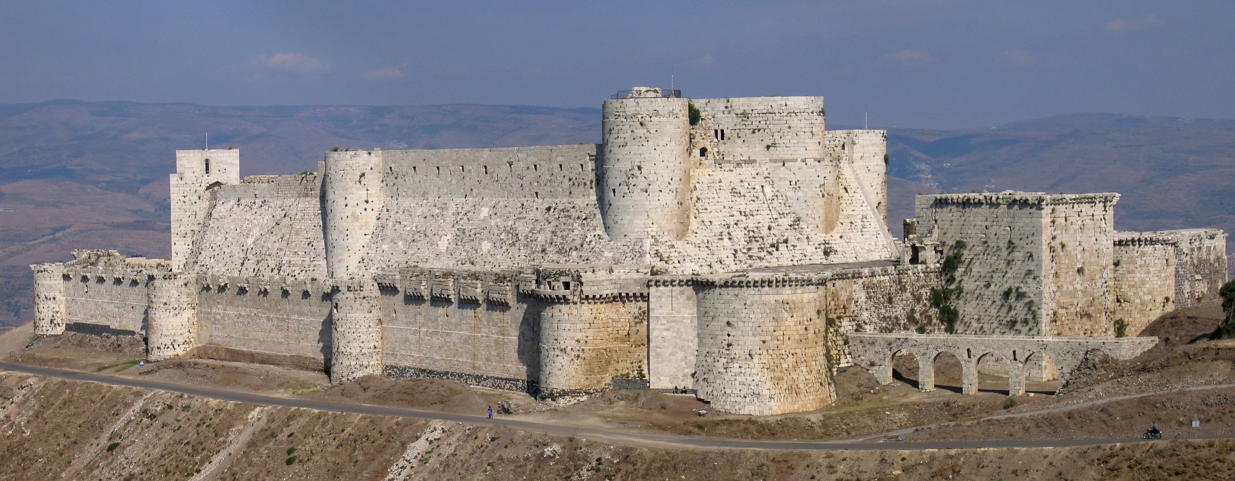
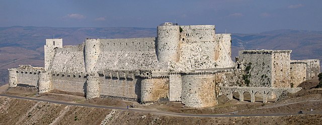
English: Krak des Chevaliers in Syria, built during the crusades for the Knights Hospitallers
Français : Le Krak des Chevaliers, en Syrie. |
| Datum | |
| Boarne |
Eigen wurk Barber, Malcolm (2004) The Two Cities: Medieval Europe 1050–1320 (Second ed.), Routledge, p. 361 ISBN: 978-0-415-17415-2. Boas, Adrian J. (1999) Crusader Archaeology: The Material Culture of the Latin East, Routledge, pp. 112–113 ISBN: 978-0-415-17361-2. |
| Auteur | Xvlun |
| Camera location | | View this and other nearby images on: OpenStreetMap |
|---|
Lisinsje
I, the copyright holder of this work, hereby publish it under the following license:
This file is licensed under the Creative Commons Attribution-Share Alike 2.5 Generic license.
- Fiel jo frij:
- te dielen – it wurk te kopiearjen, fersprieden en út te stjoeren
- te fermingen – it wurk oan te passen
- Under de neikommende betingsten:
- Nammefermelding – You must give appropriate credit, provide a link to the license, and indicate if changes were made. You may do so in any reasonable manner, but not in any way that suggests the licensor endorses you or your use.
- Lyk diele – If you remix, transform, or build upon the material, you must distribute your contributions under the same or compatible license as the original.
Assessment

|
This image has been assessed under the valued image criteria and is considered the most valued image on Commons within the scope: Krak des Chevaliers. You can see its nomination here. |
Triemskiednis
Klik op in datum/tiid om it bestân te besjen sa't it op dat stuit wie.
| Datum/Tiid | Miniatuer | ôfmjittings | Meidogger | Opmerking | |
|---|---|---|---|---|---|
| lêste | 22 mrt 2009, 09.27 | 4.015 × 1.566 (4,41 MB) | Citypeek | white balance | |
| 8 okt 2005, 22.42 | 4.015 × 1.566 (1,93 MB) | Xvlun~commonswiki |
Bestânsgebrûk
De neikommende side brûkt dit bestân:
Globaal bestânsgebrûk
De neikommende oare wiki's brûke dit bestân:
- Gebrûk op af.wikipedia.org
- Gebrûk op als.wikipedia.org
- Gebrûk op ar.wikipedia.org
- Gebrûk op ast.wikipedia.org
- Gebrûk op av.wikipedia.org
- Gebrûk op azb.wikipedia.org
- Gebrûk op be.wikipedia.org
- Gebrûk op bg.wikipedia.org
- Gebrûk op bn.wikipedia.org
- Gebrûk op ca.wikipedia.org
- Gebrûk op cs.wikipedia.org
- Gebrûk op cy.wikipedia.org
- Gebrûk op da.wikipedia.org
- Gebrûk op de.wikipedia.org
- 1110
- 1188
- 1271
- Krak des Chevaliers
- Trutzburg
- Liste des gefährdeten Welterbes
- Wikipedia:Kandidaten für exzellente Bilder/Archiv2008/17
- Liste von Burgen und Festungen in Syrien
- Portal:Burgen und Schlösser/Bild des Monats/Archiv
- Portal Diskussion:Burgen und Schlösser/Bild des Monats
- Portal:Burgen und Schlösser/Schon gewusst/Archiv2010
- Benutzer:LZ6387
- Portal:Burgen und Schlösser/Bild des Monats/Archivgalerie
- Welterbe in Syrien
- August 2015
- Portugiesisch-syrische Beziehungen
- Gebrûk op en.wikipedia.org
Mear globaal gebrûk fan dit bestân besjen.