Ofbyld:Ctcolony.png

Grutte fan dit proefbyld: 800 × 560 piksels. Oare resolúsjes: 320 × 224 piksels | 640 × 448 piksels | 1.024 × 717 piksels | 1.428 × 1.000 piksels.
Oarspronklik bestân (1.428 × 1.000 pixels, bestânsgrutte: 817 KB, MIME-type: image/png)
Gearfetting
| Beskriuwing |
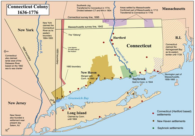
This is a map showing the Connecticut, New Haven, and Saybrook colonies from 1636-1776. It includes the territorial disputes between Connecticut and its neighbors during that time period. It does not show Connecticut's western land claims and dispute with Pennsylvania. Based primarily on descriptions from The Boundary Disputes of Connecticut by Clarence Winthrop Bowen. James R. Osgood and Company, Boston, 1882. |
| Datum | 12 oktober 2006 (original upload date) |
| Boarne | Geen machineleesbare bron opgegeven. Eigen werk aangenomen (gebaseerd op auteursrechtclaims). |
| Auteur | Geen machineleesbare auteur aanwezig. Op basis van auteursrechtclaims wordt auteur Kmusser aangenomen. |
Lisinsje
I, the copyright holder of this work, hereby publish it under the following license:
This file is licensed under the Creative Commons Attribution-Share Alike 2.5 Generic license.
- Fiel jo frij:
- te dielen – it wurk te kopiearjen, fersprieden en út te stjoeren
- te fermingen – it wurk oan te passen
- Under de neikommende betingsten:
- Nammefermelding – You must give appropriate credit, provide a link to the license, and indicate if changes were made. You may do so in any reasonable manner, but not in any way that suggests the licensor endorses you or your use.
- Lyk diele – If you remix, transform, or build upon the material, you must distribute your contributions under the same or compatible license as the original.
Format

|
This historical map image could be re-created using vector graphics as an SVG file. This has several advantages; see Commons:Media for cleanup for more information. If an SVG form of this image is available, please upload it and afterwards replace this template with
{{vector version available|new image name}}.
It is recommended to name the SVG file “Ctcolony.svg”—then the template Vector version available (or Vva) does not need the new image name parameter. |
Triemskiednis
Klik op in datum/tiid om it bestân te besjen sa't it op dat stuit wie.
| Datum/Tiid | Miniatuer | ôfmjittings | Meidogger | Opmerking | |
|---|---|---|---|---|---|
| lêste | 2 jun 2014, 06.06 | | 1.428 × 1.000 (817 KB) | JeffyP | I'm here to make the world a little bit smaller ☺ |
| 10 jan 2008, 21.19 |  | 1.428 × 1.000 (909 KB) | Kmusser | Major revision to include disputes with Massachusetts and Rhode Island. | |
| 12 okt 2006, 18.54 |  | 800 × 680 (190 KB) | Kmusser | == Summary == This is a map showing the Connecticut, New Haven, and Saybrook colonies from 1636-1776. It includes the territorial dispute between Connecticut |
Bestânsgebrûk
De neikommende side brûkt dit bestân:
Globaal bestânsgebrûk
De neikommende oare wiki's brûke dit bestân:
- Gebrûk op bg.wikipedia.org
- Gebrûk op bn.wikipedia.org
- Gebrûk op ce.wikipedia.org
- Gebrûk op da.wikipedia.org
- Gebrûk op de.wikipedia.org
- Gebrûk op en.wikipedia.org
- Connecticut
- Fishers Island, New York
- New Haven Colony
- History of Connecticut
- Connecticut Colony
- John Haynes (governor)
- Saybrook Colony
- User:Kmusser/Images
- List of colonial governors of Connecticut
- History of Long Island
- New England Colonies
- Portal:Connecticut
- Thomas Powell (American landowner)
- Border disputes between New York and Connecticut
- Gebrûk op en.wikiversity.org
- Gebrûk op es.wikipedia.org
- Gebrûk op fr.wikipedia.org
- Gebrûk op he.wikipedia.org
- Gebrûk op hu.wikipedia.org
- Gebrûk op hy.wikipedia.org
- Gebrûk op id.wikipedia.org
- Gebrûk op it.wikipedia.org
- Gebrûk op ja.wikipedia.org
Mear globaal gebrûk fan dit bestân besjen.