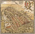
Ofbyld:De Groote Kaart van Amsterdam in 1544 (The Big Map of Amsterdam in 1544) by Cornelis Anthonisz.jpg

Oarspronklik bestân(8.738 × 8.595 pixels, bestânsgrutte: 20,92 MB, MIME-type: image/jpeg)

Dit bestân komt fan Wikimedia Commons, en kin ek troch oare projekten brûkt wurde. De beskriuwing op syn bestânsside dêre wurdt hjirûnder werjûn.

Gearfetting

Artist
Cornelis Anthonisz.  (circa 1505
date QS:P,+1505–00–00T00:00:00Z/9,P1480,Q5727902
–1553)  wikidata:Q2761474
 
Cornelis Anthonisz.
Alternative names
Cornelis Anthoniszoon, Cornelis Anthonisz. Teunissen, Cornelis Anthonisz. Teunisz., Cornelis Anthonisz. Theunissen, Cornelis Anthonisz. Thonisz.
Description Dutch painter, cartographer, engraver en drawer
Date of birth/death circa 1505
date QS:P,+1505-00-00T00:00:00Z/9,P1480,Q5727902
1553 Edit this at Wikidata
Location of birth/death Amsterdam Amsterdam
Work location
Authority file
artist QS:P170,Q2761474
Title
Nederlands: De Groote kaart van Amsterdam in 1544 van Kornelis Antoniszoon... behoorende bij het vijfde deel der geschiedenis van Amsterdam / door J. Ter Gouw, naar het oorspronkelijke gephotographeerd...
English: The Big Map of Amsterdam in 1544 by Kornelis Antoniszoon... belonging to the fifth part of the history of Amsterdam / by J. Ter Gouw, photographed after the original...
Beskriuwing
Français : Sujet : Amsterdam. Couverture : Pays-Bas. Langue : néerlandais. Éditeur : T. Van Holkema (Amsterdam).
English: Subject: Amsterdam. Coverage: Netherlands. Language: Dutch. Publisher: T. Van Holkema (Amsterdam). This is the full map. Extra info: "A bird's eye view of Amsterdam looking south. This is the city before the construction of the semi-circular ring of canals. It is bordered by the IJ, the Singel in the west, and the Kloveniersburgwal/Gelderse Kade in the east. The waterway in the middle (connecting the Dam with the IJ) is known as the Damrak. Ships were unloaded on the west bank of the Damrak, indicated on the map as ‘Opt Waeter’ (on the water). Woodcut by Cornelis Anthonisz. dated 1544. This version is a reprint published around 1885."
Datum 1885 (the original version is from 1544)
Dimensions height: 30 cm; width: 36 cm
dimensions QS:P2048,30U174728
dimensions QS:P2049,36U174728
institution QS:P195,Q193563
Inscriptions

Caption :

De vermaerde koopstadt / van Amstelredam, gheconterfeyt met alle / sijn Wateren, Bruggen, Straten, kercken, kloo- / steren, Huysen, Toorens, Poorten ende Mueren, / ende omleggende situatie, gemaekt ter eeren K. M. / ende oock den Eersamen Raedt der selver Stadt, / ende alle Liefhebberen der Konste, etc. // Wtgegeven by Cornelis Anthonizoon Schil- / der, met Octroye der K. M. onsen ghenadighsten Heere van 't selfde niet te / moghen nae-drucken noch verkoopen binnen den tijdt van ses Jaren lanck / gheduerende, ende ghedateert van den Jare duysent vijf-honderd drie-en- / veertigh, op seeckere penen int selvde Octroye begrepen, op dat hem een yege- / lijck voor schade verhoede mach. // Dese afbeeldinghe vindtmen te koop in die ver- / maerde koopstadt van Amstelredam achter de Nieuwe Kerck / by den voorsz Cornelis Anthoniszoon, Schilder / inde Schrijvende handt.
References
Français : Notice du catalogue : http://catalogue.bnf.fr/ark:/12148/cb40719984d
Source/Photographer
Français : Bibliothèque nationale de France, département Cartes et plans, GE DD-2763
Bibliothèque nationale de France
(25/28)
English: Bibliothèque nationale de France, Maps and plans department, GE DD-2763
Tastimming
(Reusing this file)
Previous public domain rationale, no longer applicable
Public domain
This image from the Bibliothèque nationale de France (BnF) is a reproduction by scanning of a bidimensional work that is now in the public domain ({{PD-scan}}). For this reason, it is in the public domain.
This image can also be seen on Gallica: Image btv1b525134777.

العربية  Deutsch  English  español  français  galego  italiano  日本語  македонски  Nederlands  português  русский  sicilianu  slovenščina  українська  +/−

Lisinsje

This is a faithful photographic reproduction of a two-dimensional, public domain work of art. The work of art itself is in the public domain for the following reason:
Public domain

This work is in the public domain in its country of origin and other countries and areas where the copyright term is the author's life plus 100 years or fewer.


This work is in the public domain in the United States because it was published (or registered with the U.S. Copyright Office) before January 1, 1929.

The official position taken by the Wikimedia Foundation is that "faithful reproductions of two-dimensional public domain works of art are public domain".
This photographic reproduction is therefore also considered to be in the public domain in the United States. In other jurisdictions, re-use of this content may be restricted; see Reuse of PD-Art photographs for details.

Captions

Add a one-line explanation of what this file represents

Items portrayed in this file

depicts Ingelsk

MIME type Ingelsk

image/jpeg

Triemskiednis

Klik op in datum/tiid om it bestân te besjen sa't it op dat stuit wie.

Datum/TiidMiniatuerôfmjittingsMeidoggerOpmerking
lêste9 apr 2023, 04.46Miniatuer foar de ferzje fan 9 apr 2023 om 04.468.738 × 8.595 (20,92 MB)ArtanisenImproved alignment of the sections, reduced grid lines (same source)
7 apr 2023, 21.34Miniatuer foar de ferzje fan 7 apr 2023 om 21.348.857 × 8.787 (22,31 MB)ArtanisenImproved spacing of the artwork sections (same source)
7 apr 2023, 09.00Miniatuer foar de ferzje fan 7 apr 2023 om 09.008.955 × 8.857 (22,76 MB)ArtanisenUploaded a work by Cornelis Anthonisz. (circa 1505-1553). Auteur du texte from Bibliothèque nationale de France, département Cartes et plans, GE DD-2763 Bibliothèque nationale de France (25/28) - http://gallica.bnf.fr/ark:/12148/btv1b525134777/ with UploadWizard

De neikommende 2 siden brûke dit bestân:

Globaal bestânsgebrûk

De neikommende oare wiki's brûke dit bestân:

Mear globaal gebrûk fan dit bestân besjen.

Metadata