Ofbyld:Deutschland Besatzungszonen 1945.svg

Size of this PNG preview of this SVG file: 473 × 599 piksels. Oare resolúsjes: 189 × 240 piksels | 379 × 480 piksels | 606 × 768 piksels | 808 × 1.024 piksels | 1.616 × 2.048 piksels | 2.183 × 2.766 piksels.
Oarspronklik bestân (SVG-bestân, nominaal 2.183 × 2.766 pixels, bestânsgrutte: 246 KB)
| Beskriuwing |
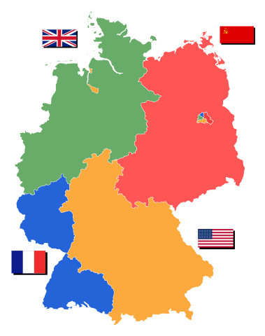
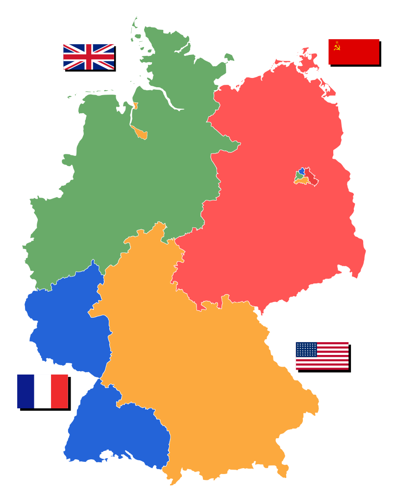
Deutsch: Nachkriegsdeutschland in den heutigen Grenzen, unterteilt in Besatzungszonen. |
||||||||
| Datum | |||||||||
| Boarne | Own work based on: Deutschland Besatzungszonen 1945.png | ||||||||
| Auteur | svg version created by glglgl | ||||||||
| Tastimming (Reusing this file) |
|
||||||||
| SVG genesis |


|
This file has been superseded by Deutschland Besatzungszonen 8 Jun 1947 - 22 Apr 1949.svg. It is recommended to use the other file. Please note that deleting superseded images requires consent.
|

|
Triemskiednis
Klik op in datum/tiid om it bestân te besjen sa't it op dat stuit wie.
| Datum/Tiid | Miniatuer | ôfmjittings | Meidogger | Opmerking | |
|---|---|---|---|---|---|
| lêste | 1 apr 2010, 01.59 | | 2.183 × 2.766 (246 KB) | Glglgl | changed size of image and location inside it |
| 1 apr 2010, 01.48 |  | 2.183 × 2.966 (247 KB) | Glglgl | taken File:Map-Germany-1947.svg (created by 52_Pickup) and cleaned up so that the borders of 1945 are shown. This replaces my old version of the file, which really was b...ad. | |
| 19 mrt 2010, 22.45 |  | 448 × 576 (946 KB) | Glglgl | {{Information |Description={{de|1=Nachkriegsdeutschland in den heutigen Grenzen, unterteilt in Besatzungszonen.}} |Source=http://commons.wikimedia.org/wiki/File:Deutschland_Besatzungszonen_1945.png |Author=svg version created by glglgl |Da |
Bestânsgebrûk
De neikommende 3 siden brûke dit bestân:
Globaal bestânsgebrûk
De neikommende oare wiki's brûke dit bestân:
- Gebrûk op ar.wikipedia.org
- Gebrûk op ast.wikipedia.org
- Gebrûk op azb.wikipedia.org
- Gebrûk op az.wikipedia.org
- Gebrûk op bg.wikipedia.org
- Gebrûk op ca.wikipedia.org
- Gebrûk op da.wikipedia.org
- Gebrûk op de.wikipedia.org
- Sowjetische Besatzungszone
- 1948
- Westzone
- Besatzungszone
- Geschichte der Deutschen Demokratischen Republik
- Berlin-Blockade
- Viermächte-Status
- Bizone
- Trizone
- Geschichte der Bundesrepublik Deutschland (bis 1990)
- Deutsche Grenzpolizei
- Amerikanische Besatzungszone
- Britische Besatzungszone
- Französische Besatzungszone
- Deutsche Teilung
- Vorlage:Navigationsleiste Besatzungszonen in Deutschland
- Vorkonstitutionelles Recht
- Wikipedia:WikiProjekt Imperialismus und Weltkriege/Vorlagen
- Himmeroder Denkschrift
- Deutsche Postgeschichte
- Postgeschichte und Briefmarken Deutschlands unter alliierter Besetzung
- Liste geflügelter Worte/W
- Benutzer Diskussion:Kandschwar/Archiv
- Briefmarken-Ausgaben der französischen Zone Rheinland-Pfalz
- Briefmarken-Jahrgang 1945 der Deutschen Reichspost
- Briefmarken-Ausgaben der französischen Zone in Deutschland
- Briefmarken-Ausgaben für Mecklenburg-Vorpommern (SBZ)
- Briefmarken-Ausgaben für Ost-Sachsen (SBZ)
- Briefmarken-Ausgaben für die Provinz Sachsen
- Briefmarken-Ausgaben für Thüringen (SBZ)
- Briefmarken-Ausgaben für West-Sachsen (SBZ)
- Vorlage:Navigationsleiste Alliierte Briefmarkenausgaben in Deutschland
- Briefmarken-Ausgaben der französischen Zone Baden
- Briefmarken-Ausgaben der französischen Zone Württemberg-Hohenzollern
- Briefmarken-Ausgaben der amerikanischen und britischen Zone in Deutschland
- Briefmarken-Ausgaben der sowjetischen Besatzungszone
- Briefmarken-Ausgaben für Berlin und Brandenburg
Mear globaal gebrûk fan dit bestân besjen.