Ofbyld:Driving standards historic.png

Grutte fan dit proefbyld: 800 × 370 piksels. Oare resolúsjes: 320 × 148 piksels | 640 × 296 piksels | 1.357 × 628 piksels.
Oarspronklik bestân (1.357 × 628 pixels, bestânsgrutte: 36 KB, MIME-type: image/png)

|
Ofbyld:Driving standards historic.svg is in fektorferzje fan dizze triem. As net fan sljochtere kwaliteit tsjinnet dizze brûkt te wurden yn plak fan dizze rasterôfbylding.
File:Driving standards historic.png → File:Driving standards historic.svg
Sjoch Help:SVG foar mear ynformaasje. |
 |
Gearfetting
| Beskriuwing |
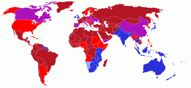
User created world map showing the driving directions for all countries and any changes that have occurred in the past starting with Finland's change in 1858
|
| Datum | 13 maaie 2006 (original upload date) |
| Boarne | Geen machineleesbare bron opgegeven. Eigen werk aangenomen (gebaseerd op auteursrechtclaims). |
| Auteur | Geen machineleesbare auteur aanwezig. Op basis van auteursrechtclaims wordt auteur UKPhoenix79 aangenomen. |
Lisinsje
I, the copyright holder of this work, hereby publish it under the following license:
This file is licensed under the Creative Commons Attribution-Share Alike 2.5 Generic license.
- Fiel jo frij:
- te dielen – it wurk te kopiearjen, fersprieden en út te stjoeren
- te fermingen – it wurk oan te passen
- Under de neikommende betingsten:
- Nammefermelding – You must give appropriate credit, provide a link to the license, and indicate if changes were made. You may do so in any reasonable manner, but not in any way that suggests the licensor endorses you or your use.
- Lyk diele – If you remix, transform, or build upon the material, you must distribute your contributions under the same or compatible license as the original.
History on English Wikipedia
- (Delete all revisions of this file) (cur) 12:54, 16 June 2006 . . UKPhoenix79 (Talk | contribs | block) . . 1357×628 (19,631 bytes) (retry)
- (del) (rev) 04:59, 16 June 2006 . . UKPhoenix79 (Talk | contribs | block) . . 1357×628 (19,631 bytes) (Looking at a map of the Austro-Hungarian Empire it becae clear that more modern nations had parts that drove on the left)
- (del) (rev) 09:57, 26 May 2006 . . UKPhoenix79 (Talk | contribs | block) . . 1357×628 (19,565 bytes)
- (del) (rev) 08:11, 15 May 2006 . . UKPhoenix79 (Talk | contribs | block) . . 1357×628 (19,547 bytes) (Fixed error)
- (del) (rev) 07:36, 15 May 2006 . . UKPhoenix79 (Talk | contribs | block) . . 1357×628 (19,531 bytes)
- (del) (rev) 17:22, 14 May 2006 . . NFH (Talk | contribs | block) . . 1357×628 (19,312 bytes) (Reverted to earlier revision)
- (del) (rev) 17:21, 14 May 2006 . . NFH (Talk | contribs | block) . . 1357×628 (19,056 bytes) (Reverted to earlier revision)
- (del) (rev) 17:21, 14 May 2006 . . NFH (Talk | contribs | block) . . 1357×628 (19,056 bytes) (Reverted to earlier revision)
- (del) (rev) 23:42, 13 May 2006 . . UKPhoenix79 (Talk | contribs | block) . . 1357×628 (19,312 bytes)
- (del) (rev) 23:39, 13 May 2006 . . UKPhoenix79 (Talk | contribs | block) . . 1357×628 (19,271 bytes)
- (del) (rev) 14:00, 13 May 2006 . . UKPhoenix79 (Talk | contribs | block) . . 1357×628 (19,056 bytes) (User created world map showing historic driving directions for all countries before Finland's change in 1858 Red means driving on right.
Blue means driving on left.
)
Triemskiednis
Klik op in datum/tiid om it bestân te besjen sa't it op dat stuit wie.
| Datum/Tiid | Miniatuer | ôfmjittings | Meidogger | Opmerking | |
|---|---|---|---|---|---|
| lêste | 12 feb 2018, 16.50 | | 1.357 × 628 (36 KB) | Maphobbyist | South Sudan border, same color as Sudan |
| 7 okt 2008, 06.25 |  | 1.357 × 628 (52 KB) | 8q67n4tqr5 | United States was one drove on left, now drives on right (1792) Category:Right- and left-hand traffic | |
| 7 okt 2008, 06.23 |  | 1.357 × 628 (52 KB) | 8q67n4tqr5 | User created world map showing the driving directions for all countries and any changes that have occurred in the past starting with Finland's change in 1858 <font color="#B41624">Red - driving on right; also known as [[Left-hand_drive#Terminology|Right | |
| 27 jul 2006, 16.52 |  | 1.357 × 628 (19 KB) | Conscious | newest version from en: | |
| 26 mai 2006, 13.17 |  | 1.357 × 628 (19 KB) | UKPhoenix79 | Updated version | |
| 13 mai 2006, 12.16 |  | 1.357 × 628 (19 KB) | UKPhoenix79 | User created world map showing historic driving directions for all countries before Finland's change in 1858 <font color="#B41624">Red means driving on right.</font><br /> <font color="#2C2EDC">Blue means driving on left.</font><br /> |
Bestânsgebrûk
Der binne gjin siden dy't dit bestân brûke.
Globaal bestânsgebrûk
De neikommende oare wiki's brûke dit bestân:
- Gebrûk op en.wikipedia.org
- Gebrûk op hu.wikipedia.org
- Gebrûk op smn.wikipedia.org