Ofbyld:East China Sea Map.jpg
Gjin hegere resolúsje beskikber.
East_China_Sea_Map.jpg (600 × 533 pixels, bestânsgrutte: 88 KB, MIME-type: image/jpeg)

|
This map image could be re-created using vector graphics as an SVG file. This has several advantages; see Commons:Media for cleanup for more information. If an SVG form of this image is available, please upload it and afterwards replace this template with
{{vector version available|new image name}}.
It is recommended to name the SVG file “East China Sea Map.svg”—then the template Vector version available (or Vva) does not need the new image name parameter. |


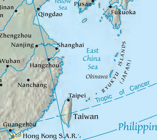
Map of the East China Sea. Mapa Východočínského moře (popisky v angličtině). Source: tr:Resim:DoğuÇinDenizi.jpg Licence: public domain, because it originally comes from the CIA World Factbook, i.e. from a United States federal governemental agency.
| |
This work has been released into the public domain by its author, Danbury, at the Ingelsk Wikipedy project. This applies worldwide. In case this is not legally possible: |
Triemskiednis
Klik op in datum/tiid om it bestân te besjen sa't it op dat stuit wie.
| Datum/Tiid | Miniatuer | ôfmjittings | Meidogger | Opmerking | |
|---|---|---|---|---|---|
| lêste | 13 jun 2007, 15.26 | | 600 × 533 (88 KB) | Zeman | Map of the East China Sea. Mapa Východočínského moře (popisky v angličtině). Source: tr:Resim:DoğuÇinDenizi.jpg Licence: public domain, because it originally comes from the CIA World Factbook, i.e. from a United States federal governemental |
Bestânsgebrûk
Der binne gjin siden dy't dit bestân brûke.
Globaal bestânsgebrûk
De neikommende oare wiki's brûke dit bestân:
- Gebrûk op ar.wikipedia.org
- Gebrûk op arz.wikipedia.org
- Gebrûk op bcl.wikipedia.org
- Gebrûk op be.wikipedia.org
- Gebrûk op bn.wikipedia.org
- Gebrûk op cdo.wikipedia.org
- Gebrûk op cs.wikipedia.org
- Gebrûk op en.wikipedia.org
- Gebrûk op eo.wikipedia.org
- Gebrûk op es.wikipedia.org
- Gebrûk op eu.wikipedia.org
- Gebrûk op fa.wikipedia.org
- Gebrûk op gl.wikipedia.org
- Gebrûk op he.wikipedia.org
- Gebrûk op hr.wikipedia.org
- Gebrûk op hy.wikipedia.org
- Gebrûk op id.wikipedia.org
- Gebrûk op ilo.wikipedia.org
- Gebrûk op incubator.wikimedia.org
- Gebrûk op is.wikipedia.org
- Gebrûk op it.wikipedia.org
- Gebrûk op ja.wikipedia.org
- Gebrûk op jv.wikipedia.org
- Gebrûk op kk.wikipedia.org
- Gebrûk op ko.wikipedia.org
- Gebrûk op lt.wikipedia.org
- Gebrûk op mk.wikipedia.org
- Gebrûk op ml.wikipedia.org
- Gebrûk op ms.wikipedia.org
- Gebrûk op no.wikipedia.org
- Gebrûk op pa.wikipedia.org
- Gebrûk op pl.wiktionary.org
- Gebrûk op pt.wikipedia.org
- Gebrûk op ro.wikipedia.org
- Gebrûk op ru.wikipedia.org
- Gebrûk op ru.wikinews.org
Mear globaal gebrûk fan dit bestân besjen.