Ofbyld:England-878ad.jpg

Grutte fan dit proefbyld: 471 × 599 piksels. Oare resolúsjes: 189 × 240 piksels | 377 × 480 piksels | 735 × 935 piksels.
Oarspronklik bestân (735 × 935 pixels, bestânsgrutte: 127 KB, MIME-type: image/jpeg)

|
This map has been uploaded by Electionworld from en.wikipedia.org to enable the |
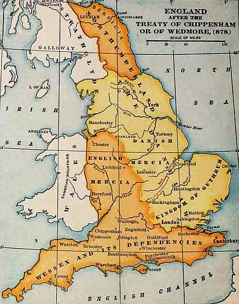
England and Wales at the time of the Treaty of Chippenham (AD 878). From the Atlas of European History, Earle W Dowe (d. 1946), G Bell and Sons, London, 1910
[]
-
 Cymraeg
 -
 Deutsch
 -
 English
 -
 English
 -
 English
 -
 español
 -
 français
 -
 Nederlands
 -
 polski
 -
 magyar


.svg)


|
The author died in 1946, so this work is in the public domain in its country of origin and other countries and areas where the copyright term is the author's life plus 75 years or fewer. This work is in the public domain in the United States because it was published (or registered with the U.S. Copyright Office) before January 1, 1929. | |
| This file has been identified as being free of known restrictions under copyright law, including all related and neighboring rights. | |
Triemskiednis
Klik op in datum/tiid om it bestân te besjen sa't it op dat stuit wie.
| Datum/Tiid | Miniatuer | ôfmjittings | Meidogger | Opmerking | |
|---|---|---|---|---|---|
| lêste | 7 nov 2011, 21.27 | | 735 × 935 (127 KB) | Hel-hama | same source, better version of the image |
| 29 des 2006, 17.49 |  | 693 × 879 (79 KB) | Electionworld | {{ew|en|Adamsan}} England and Wales at the time of the Treaty of Chippenham (AD 878). From the Atlas of European History, Earle W Dowe, G Bell and Sons, London, 1910 {{PD-US}} |
Bestânsgebrûk
De neikommende side brûkt dit bestân:
Globaal bestânsgebrûk
De neikommende oare wiki's brûke dit bestân:
- Gebrûk op ar.wikipedia.org
- Gebrûk op br.wikipedia.org
- Gebrûk op cs.wikipedia.org
- Gebrûk op en.wikipedia.org
- Talk:Sub-Roman Britain
- Portal:Denmark/Selected article/2006 archive
- Portal:Denmark/Selected article/Week 20, 2006
- Portal:Denmark/Selected article/2007 archive
- Portal:Denmark/Selected article/Week 4, 2007
- Portal:Denmark/Selected article/Week 5, 2007
- Portal:Denmark/Selected article/Week 45, 2007
- Portal:Denmark/Selected article/Week 46, 2007
- Portal:Denmark/Selected article/2008 archive
- Portal:Denmark/Selected article/Week 3, 2008
- User:Amitchell125/danelaw
- Gebrûk op eo.wikipedia.org
- Gebrûk op hu.wikipedia.org
- Gebrûk op id.wikipedia.org
- Gebrûk op is.wikipedia.org
- Gebrûk op it.wikipedia.org
- Gebrûk op ja.wikipedia.org
- Gebrûk op pt.wikipedia.org
- Gebrûk op sh.wikipedia.org
- Gebrûk op simple.wikipedia.org
- Gebrûk op sk.wikipedia.org
- Gebrûk op th.wikipedia.org
- Gebrûk op uk.wikipedia.org
- Gebrûk op zh.wikipedia.org