Ofbyld:Europe and the Near East at 476 AD.png

Grutte fan dit proefbyld: 800 × 556 piksels. Oare resolúsjes: 320 × 222 piksels | 640 × 445 piksels | 1.024 × 712 piksels | 1.280 × 890 piksels | 2.830 × 1.967 piksels.
Oarspronklik bestân (2.830 × 1.967 pixels, bestânsgrutte: 1,58 MB, MIME-type: image/png)

|
This historical map image could be re-created using vector graphics as an SVG file. This has several advantages; see Commons:Media for cleanup for more information. If an SVG form of this image is available, please upload it and afterwards replace this template with
{{vector version available|new image name}}.
It is recommended to name the SVG file “Europe and the Near East at 476 AD.svg”—then the template Vector version available (or Vva) does not need the new image name parameter. |
Gearfetting
| Beskriuwing |
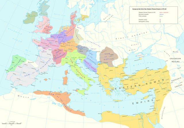
English: Political division in Europe, North Africa and Near East after the end of the Western Roman Empire in 476 AD. Romance area added since H. M. Glessegen (dir.), Handbuch der Romanische Sprachgeschichte, Berlin/New York, p. 544-555. Modified Gaëls / Picts / Britons (see discussion file).
Español: Mapa político de Europa, el Norte de África y Oriente Próximo tras el fin del Imperio Romano de Occidente en 476 d.C. Área románica añadida desde H. M. Glessegen (dir.), Handbuch der Romanische Sprachgeschichte, Berlín/Nueva York, p. 544-555. Gaëls / Pictos / Británicos modificados (ver archivo de discusión).
Français : L'Europe, l'Afrique du Nord et le Proche-Orient après la fin de l'Empire romain d'Occident en 476. Limites des langues romanes ajoutées d'après H. M. Glessegen (dir.), Handbuch der Romanische Sprachgeschichte, Berlin/New York, p. 544-555. Modifié les Gaëls / Pictes / Bretons d'après la page de discussion. |
| Datum | |
| Boarne | Putzger Historischer Weltatlas, Cornelsen, Berlin 1992 ISBN 3-464-00176-8, pp. 34-35 (maps by R. Hachmann). |
| Auteur | Guriezous |
| Tastimming (Reusing this file) |
Eigen wurk |
Lisinsje
I, the copyright holder of this work, hereby publish it under the following license:
This file is licensed under the Creative Commons Attribution-Share Alike 4.0 International license.
- Fiel jo frij:
- te dielen – it wurk te kopiearjen, fersprieden en út te stjoeren
- te fermingen – it wurk oan te passen
- Under de neikommende betingsten:
- Nammefermelding – You must give appropriate credit, provide a link to the license, and indicate if changes were made. You may do so in any reasonable manner, but not in any way that suggests the licensor endorses you or your use.
- Lyk diele – If you remix, transform, or build upon the material, you must distribute your contributions under the same or compatible license as the original.
Triemskiednis
Klik op in datum/tiid om it bestân te besjen sa't it op dat stuit wie.
| Datum/Tiid | Miniatuer | ôfmjittings | Meidogger | Opmerking | |
|---|---|---|---|---|---|
| lêste | 5 okt 2023, 14.14 | | 2.830 × 1.967 (1,58 MB) | GPinkerton | Reverted to version as of 03:35, 9 January 2022 (UTC) this manipulation of maps is forbidden COM:CROP |
| 24 sep 2023, 11.47 |  | 2.830 × 1.967 (1,79 MB) | Claude Zygiel | Add details romance languages of the time according with the article "Romance languages" | |
| 22 sep 2023, 18.52 |  | 2.830 × 1.967 (1,78 MB) | Claude Zygiel | Gaëls. All germanic peoples colored. Romance area added since H. M. Glessegen (dir.), {{de}} ''Handbuch der Romanische Sprachgeschichte'', Berlin/New York, p. 544-555. | |
| 9 jan 2022, 05.35 |  | 2.830 × 1.967 (1,58 MB) | Jul059 | Lossless file size reduction | |
| 7 mai 2016, 17.33 |  | 2.830 × 1.967 (2,2 MB) | Guriezous | Eliminados nombres | |
| 5 mai 2016, 22.08 |  | 2.830 × 1.967 (2,21 MB) | Guriezous | Añadidos nombres. | |
| 4 mai 2016, 19.43 |  | 2.830 × 1.967 (2,2 MB) | Guriezous | Eliminados nombres rezagados. | |
| 24 apr 2016, 10.52 |  | 2.830 × 1.967 (2,21 MB) | Guriezous | Eliminados nombres de provincias en gran parte aleatorias | |
| 16 apr 2016, 12.12 |  | 2.830 × 1.967 (2,29 MB) | Guriezous | Eliminada Austrasia | |
| 16 apr 2016, 12.11 |  | 2.830 × 1.967 (2,29 MB) | Guriezous | Eliminada Austrasia |
Bestânsgebrûk
De neikommende side brûkt dit bestân:
Globaal bestânsgebrûk
De neikommende oare wiki's brûke dit bestân:
- Gebrûk op ar.wikipedia.org
- Gebrûk op ast.wikipedia.org
- Gebrûk op azb.wikipedia.org
- Gebrûk op bg.wikipedia.org
- Gebrûk op bn.wikipedia.org
- Gebrûk op ca.wikipedia.org
- Gebrûk op cs.wikipedia.org
- Gebrûk op de.wikipedia.org
- Gebrûk op de.wikibooks.org
- Gebrûk op de.wikiversity.org
- Gebrûk op el.wikipedia.org
- Gebrûk op en.wikipedia.org
- Alemanni
- Frisians
- Germanic peoples
- Middle Ages
- Marcomanni
- Ostrogoths
- Saxons
- Visigoths
- Vandals
- Rugii
- Thuringii
- Zeno (emperor)
- Migration Period
- Basiliscus
- Gepids
- Timeline of Jerusalem
- Campaign history of the Roman military
- Succession of the Roman Empire
- Fall of the Western Roman Empire
- French people
- Germanic kingship
Mear globaal gebrûk fan dit bestân besjen.