Ofbyld:India (orthographic projection).svg
Oarspronklik bestân(SVG-bestân, nominaal 541 × 541 pixels, bestânsgrutte: 280 KB)

Dit bestân komt fan Wikimedia Commons, en kin ek troch oare projekten brûkt wurde. De beskriuwing op syn bestânsside dêre wurdt hjirûnder werjûn.

Gearfetting

Beskriuwing
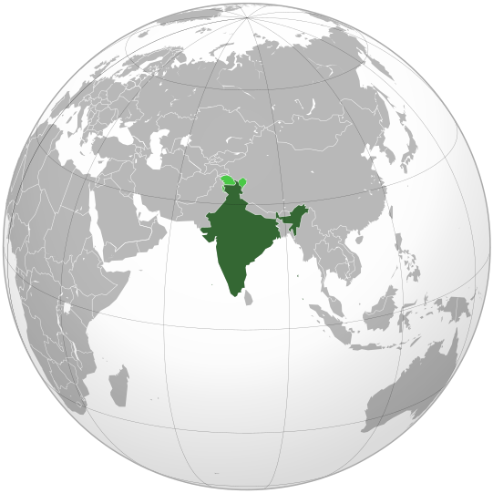
English: India. Area controlled by India in dark green; claimed but not controlled areas in light green.
Datum
Boarne

Own work,

 
This vector image was created with Inkscape .

Aquarius.geomar.de

বাংলা  English  español  français  italiano  日本語  македонски  sicilianu  中文(简体)  中文(繁體)  +/−

GNU head Der wurdt tastimming jûn ta kopiearjen, fersprieden en/of wizigjen fan dit dokumint ûnder de betinksten fan de GNU-lisinsje foar iepen dokumintaasje, ferzje 1.2, as eltse lettere ferzje útjûn troch de Free Software Foundation; sûnder Ynfariante Seksjes, sûnder Omkaftteksten foar de Foarkante en sûnder Omkaftteksten foar de Efterkante. In kopy fan de lisinsje is opnaam yn de seksje "Text of the GNU Free Documentation License".
Auteur Ssolbergj (talk)
Oare ferzjes

Derivative works of this file:

This is a Grey & green orthographic projection map.
العربية: الرجاء، قراءة الميثاق.
বাংলা: দয়া করে, রীতিনীতিটি পড়ুন
Deutsch: Bitte lies die Konventionen.
English: Please, read the conventions.
Español: Por favor, lea las convenciones.
Filipino: Paki-basa ang mga kumbensyon.
Français : S'il vous plaît, lisez les conventions.
हिन्दी: कृपया सभागमों को पढ़ लें.
Bahasa Indonesia: Silakan, baca konvensi.
Italiano: Si prega di leggere le convenzioni.
ქართული: გთხოვთ, გაეცნოთ კონვენციებს.
Português: Por favor, leia as convenções.
Русский: Пожалуйста, прочитайте соглашения.
Українська: Будь ласка, прочитайте конвенції.
Tiếng Việt: Hãy đọc công văn trước khi đăng.
World maps

Africa

हिन्दी: अफ्रीका
ქართული: აფრიკა.

Eastern Africa

Southern Africa

Central Africa

Northern Africa

Western Africa

Americas

ქართული: ამერიკა.
हिन्दी: अमेरिका

North America

Central America

Caribbean

South America

Asia

ქართული: აზია.
Português: Ásia.
Українська: Азія.

East

Português: Ásia Oriental.
Українська: Східна Азія.

Central

हिन्दी: मध्य एशिया
Português: Ásia Central.
Українська: Центральна Азія.

Southeast

Bahasa Indonesia: Asia tenggara
Português: Sudeste Asiático.

South

(भारतीय उपमहाद्वीप)
Português: Sul da Ásia.
Українська: Південна Азія.

Western

Português: Sudoeste da Ásia.
Українська: Передня Азія.

Europe

हिन्दी: यूरोप
ქართული: ევროპა.
Português: Europa.
Română: Europa.
Русский: Европа.
Українська: Європа.

Countries

Oceania

हिन्दी: ओशिआनिया
ქართული: ოკეანეთი.
Português: Oceania.
Українська: Океанія.

Intercontinental

Português: Intercontinental.
Українська: Міжконтинентальні.

Historical

English: Unions, Organizations, Kingdoms, Empires
Español: Uniones, Organizaciones, Reinos, Imperios
Filipino: Mga Unyon, Organisasyon, Kaharian, Imperyo
Français : Unions, Organisations, Royaumes, Empires
हिन्दी: संघ, संगठन, राज्य, साम्राज्य व ऐतिहासिक देश
ქართული: გაერთიანებები, ორგანიზაციები, სამეფოები, იმპერიები
Português: Estados extintos.
Tagalog: Mga Unyon, Organisasyon, Kaharian, Imperyo
Українська: Союзи, Організації, Королівства, Імперії

Subnationals

हिन्दी: उपराष्ट्रीय इकाईयाँ
Orthographic projections maps created by Ssolbergj
Orthographic projections maps created by Ssolbergj:

Lisinsje

I, the copyright holder of this work, hereby publish it under the following licenses:
GNU head Der wurdt tastimming jûn ta kopiearjen, fersprieden en/of wizigjen fan dit dokumint ûnder de betinksten fan de GNU-lisinsje foar iepen dokumintaasje, ferzje 1.2, as eltse lettere ferzje útjûn troch de Free Software Foundation; sûnder Ynfariante Seksjes, sûnder Omkaftteksten foar de Foarkante en sûnder Omkaftteksten foar de Efterkante. In kopy fan de lisinsje is opnaam yn de seksje "Text of the GNU Free Documentation License".
w:fy:Creative Commons
Nammefermelding Lyk diele
This file is licensed under the Creative Commons Attribution-Share Alike 3.0 Unported license.
Fiel jo frij:
  • te dielen – it wurk te kopiearjen, fersprieden en út te stjoeren
  • te fermingen – it wurk oan te passen
Under de neikommende betingsten:
  • Nammefermelding – You must give appropriate credit, provide a link to the license, and indicate if changes were made. You may do so in any reasonable manner, but not in any way that suggests the licensor endorses you or your use.
  • Lyk diele – If you remix, transform, or build upon the material, you must distribute your contributions under the same or compatible license as the original.
You may select the license of your choice.
{{{template}}} Warning! According to Indian law, it is illegal to produce maps that in the view of the Indian government, misrepresent Indian territories by showing areas the Indian government claims ownership of but does not control as not belonging to India or as being contested.

Captions

Add a one-line explanation of what this file represents
india

Items portrayed in this file

depicts Ingelsk

copyrighted Ingelsk

inception Ingelsk

novimber 2008

MIME type Ingelsk

image/svg+xml

Triemskiednis

Klik op in datum/tiid om it bestân te besjen sa't it op dat stuit wie.

(nijste | âldste) Besjoch (10 nijer | ) (10 | 20 | 50 | 100 | 250 | 500)
Datum/TiidMiniatuerôfmjittingsMeidoggerOpmerking
lêste26 apr 2023, 09.10Miniatuer foar de ferzje fan 26 apr 2023 om 09.10541 × 541 (280 KB)Swtadi143Reverted to version as of 07:34, 16 September 2021 (UTC) siachen glacier is fully controlled by india and not india pakistan jointly, see Siachen conflict for context.
20 sep 2021, 12.02Miniatuer foar de ferzje fan 20 sep 2021 om 12.02512 × 512 (155 KB)Ytpks896Reverted to version as of 17:38, 6 September 2021 (UTC) Siachen is a disputed territory not fully controlled by single country it is controlled by both Pakistan and india & some parts by china
16 sep 2021, 09.34Miniatuer foar de ferzje fan 16 sep 2021 om 09.34541 × 541 (280 KB)Ksh.andronexusReverted to version as of 16:08, 19 December 2019 (UTC)
6 sep 2021, 19.38Miniatuer foar de ferzje fan 6 sep 2021 om 19.38512 × 512 (155 KB)MilenioscuroSiachen is a disputed territory between China, India and Pakistan
19 des 2019, 18.08Miniatuer foar de ferzje fan 19 des 2019 om 18.08541 × 541 (280 KB)Goran tek-enAdded border for South Sudan as requested by {{u|Maphobbyist}}
21 okt 2017, 16.04Miniatuer foar de ferzje fan 21 okt 2017 om 16.04541 × 541 (139 KB)Goran tek-enAdded Siachen Glacier as requested by {{u|King Prithviraj II}}
12 sep 2012, 23.31Miniatuer foar de ferzje fan 12 sep 2012 om 23.31541 × 541 (167 KB)PalosirkkaScrubbed with http://codedread.com/scour/
16 nov 2009, 01.40Miniatuer foar de ferzje fan 16 nov 2009 om 01.40541 × 541 (573 KB)Shibo77+Eritrea, Yemen; -neutral zone
1 nov 2009, 15.18Miniatuer foar de ferzje fan 1 nov 2009 om 15.18541 × 541 (496 KB)Pahari SahibMap showing territory governered by India, see map of Pakistan
11 mrt 2009, 15.17Miniatuer foar de ferzje fan 11 mrt 2009 om 15.17541 × 541 (572 KB)TryphonReverted to version as of 22:12, 13 February 2009: please use the talk page before reverting this image; there are apparently many people who want the map this way.
(nijste | âldste) Besjoch (10 nijer | ) (10 | 20 | 50 | 100 | 250 | 500)

De neikommende side brûkt dit bestân:

Globaal bestânsgebrûk

De neikommende oare wiki's brûke dit bestân:

Mear globaal gebrûk fan dit bestân besjen.

Metadata