Ofbyld:International Hydrographic Organization countries.PNG

Grutte fan dit proefbyld: 800 × 370 piksels. Oare resolúsjes: 320 × 148 piksels | 640 × 296 piksels | 1.350 × 625 piksels.
Oarspronklik bestân (1.350 × 625 pixels, bestânsgrutte: 37 KB, MIME-type: image/png)

|
This organization map image could be re-created using vector graphics as an SVG file. This has several advantages; see Commons:Media for cleanup for more information. If an SVG form of this image is available, please upload it and afterwards replace this template with
{{vector version available|new image name}}.
It is recommended to name the SVG file “International Hydrographic Organization countries.svg”—then the template Vector version available (or Vva) does not need the new image name parameter. |
Gearfetting
| Beskriuwing |
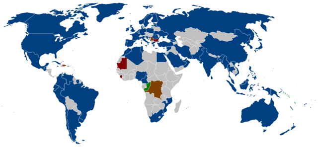
English: The member states of the International Hydrographic Organization as listed on their website.
Blue = members
Brown = suspended members
Red = approved, but awaiting deposit of Instrument of Accession
Green = membership Applications Deutsch: Die Mitgliedsstaaten der Internationalen Hydrographischen Organisation wie auf der Webseite angegeben.
Blau = Mitglieder
Braun = suspendierte Mitglieder
Rot = genehmigt, aber in Erwartung der Hinterlegung der Beitrittsurkunde
Grün = Mitgliedschaftsanträge |
| Boarne | |
| Auteur |
Lisinsje

|
Der wurdt tastimming jûn ta kopiearjen, fersprieden en/of wizigjen fan dit dokumint ûnder de betinksten fan de GNU-lisinsje foar iepen dokumintaasje, ferzje 1.2, as eltse lettere ferzje útjûn troch de Free Software Foundation; sûnder Ynfariante Seksjes, sûnder Omkaftteksten foar de Foarkante en sûnder Omkaftteksten foar de Efterkante. In kopy fan de lisinsje is opnaam yn de seksje "Text of the GNU Free Documentation License". |
| This file is licensed under the Creative Commons Attribution-Share Alike 3.0 Unported license. | ||
| ||
| This licensing tag was added to this file as part of the GFDL licensing update. |
Triemskiednis
Klik op in datum/tiid om it bestân te besjen sa't it op dat stuit wie.
| Datum/Tiid | Miniatuer | ôfmjittings | Meidogger | Opmerking | |
|---|---|---|---|---|---|
| lêste | 8 sep 2015, 23.31 | | 1.350 × 625 (37 KB) | Zntrip | Updated |
| 9 jul 2011, 14.47 |  | 1.350 × 625 (53 KB) | Maphobbyist | South Sudan has become independent on July 9, 2011. Sudan and South Sudan are shown with the new international border between them. | |
| 22 sep 2008, 12.28 |  | 1.350 × 625 (30 KB) | Jackaranga | update | |
| 22 sep 2008, 12.24 |  | 1.350 × 625 (30 KB) | Jackaranga | update | |
| 6 jun 2006, 05.17 |  | 1.350 × 625 (54 KB) | Zntrip | Added Montenegro | |
| 16 mai 2006, 04.44 |  | 1.350 × 625 (54 KB) | Zntrip | added more stiff | |
| 16 mai 2006, 04.39 |  | 1.350 × 625 (54 KB) | Zntrip | Updated | |
| 28 apr 2006, 14.25 |  | 1.357 × 628 (53 KB) | Roke~commonswiki | forgot china | |
| 28 apr 2006, 14.23 |  | 1.357 × 628 (53 KB) | Roke~commonswiki | member states of the w:International Hydrographic Organization as listed on their [http://www.iho.shom.fr/ website] *yellow= members *orange = suspended members (note there is a mistake in their map - which shows the republic of Congo, instead of t |
Bestânsgebrûk
De neikommende side brûkt dit bestân:
Globaal bestânsgebrûk
De neikommende oare wiki's brûke dit bestân:
- Gebrûk op an.wikipedia.org
- Gebrûk op ar.wikipedia.org
- Gebrûk op ast.wikipedia.org
- Gebrûk op ca.wikipedia.org
- Gebrûk op de.wikipedia.org
- Gebrûk op en.wikipedia.org
- Gebrûk op eo.wikipedia.org
- Gebrûk op es.wikipedia.org
- Gebrûk op gl.wikipedia.org
- Gebrûk op he.wikipedia.org
- Gebrûk op it.wikipedia.org
- Gebrûk op ja.wikipedia.org
- Gebrûk op ko.wikipedia.org
- Gebrûk op mr.wikipedia.org
- Gebrûk op ms.wikipedia.org
- Gebrûk op nl.wikipedia.org
- Gebrûk op pl.wikipedia.org
- Gebrûk op pt.wikipedia.org
- Gebrûk op sw.wikipedia.org
- Gebrûk op vi.wikipedia.org
- Gebrûk op zh.wikipedia.org