Ofbyld:IsleofWightmap 1945.jpg
Grutte fan dit proefbyld: 800 × 557 piksels. Oare resolúsjes: 320 × 223 piksels | 640 × 446 piksels | 1.024 × 713 piksels | 1.280 × 891 piksels | 2.264 × 1.576 piksels.
Oarspronklik bestân (2.264 × 1.576 pixels, bestânsgrutte: 996 KB, MIME-type: image/jpeg)
This work is an Ordnance Survey map over 50 years old, which is covered by Crown Copyright which in this case expires 50 years after publication. Ordnance Survey does however ask that they be credited and that the date of publication be given.
Any ancillary rights gained through the creation of the electronic version are granted as freely usable under any circumstances.
|
This work created by the United Kingdom Government is in the public domain.
This is because it is one of the following:
HMSO has declared that the expiry of Crown Copyrights applies worldwide (ref: HMSO Email Reply)
|
 |
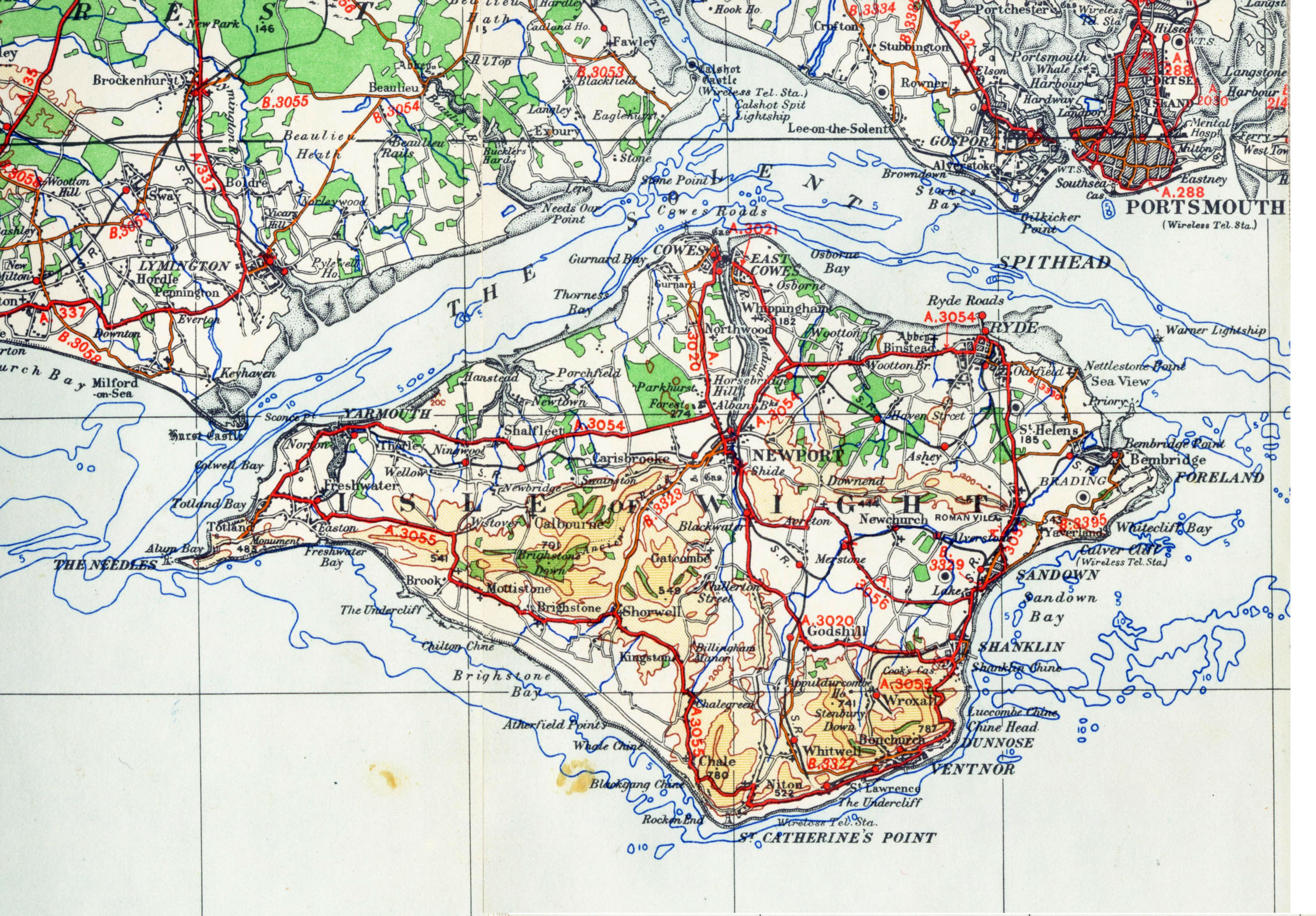
| Beskriuwing | OS map from 1945 1/4 inch to the mile sheet 11 |
| Datum | |
| Boarne | old OS map |
| Auteur | OS |
| Oare ferzjes |
|

Triemskiednis
Klik op in datum/tiid om it bestân te besjen sa't it op dat stuit wie.
| Datum/Tiid | Miniatuer | ôfmjittings | Meidogger | Opmerking | |
|---|---|---|---|---|---|
| lêste | 10 nov 2006, 23.45 | | 2.264 × 1.576 (996 KB) | Bastique | Modified levels, modified size to more manageable size. |
| 6 nov 2006, 20.18 |  | 4.528 × 3.152 (6,06 MB) | Geni | {{oldOS}} {{Information |Description=OS map from 1945 1/4 inch to the mile sheet 11 |Source=old OS map |Date=1945 |Author=OS |Permission=none needed |other_versions= }} |
Bestânsgebrûk
De neikommende side brûkt dit bestân:
Globaal bestânsgebrûk
De neikommende oare wiki's brûke dit bestân:
- Gebrûk op da.wikipedia.org
- Gebrûk op de.wikipedia.org
- Gebrûk op en.wikipedia.org
- Gebrûk op es.wikipedia.org
- Gebrûk op fr.wikipedia.org
- Gebrûk op he.wikipedia.org
- Gebrûk op pl.wikipedia.org
- Gebrûk op ru.wikipedia.org
- Gebrûk op sv.wikipedia.org
- Gebrûk op zh.wikipedia.org