Ofbyld:Kaart IJssellinie.JPG

Grutte fan dit proefbyld: 439 × 599 piksels. Oare resolúsjes: 176 × 240 piksels | 352 × 480 piksels | 563 × 768 piksels | 751 × 1.024 piksels | 1.299 × 1.772 piksels.
Oarspronklik bestân (1.299 × 1.772 pixels, bestânsgrutte: 502 KB, MIME-type: image/jpeg)
Gearfetting
| Beskriuwing |
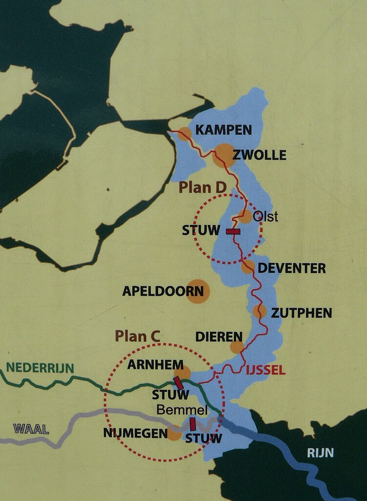
Nederlands: Kaart van de IJssellinie met daarop aangegeven de drie stuwen en in lichtblauw het inundatiegebied. Kaart gezien op informatieborden bij de IJssellinie op het landgoed De Haere in Olst. English: Map of the IJssel Line with the three movable floating dams and in light blue the area that could be inundated. |
| Datum | |
| Boarne | Eigen wurk |
| Auteur | Zandcee |
Lisinsje
I, the copyright holder of this work, hereby publish it under the following license:
This file is licensed under the Creative Commons Attribution-Share Alike 4.0 International license.
- Fiel jo frij:
- te dielen – it wurk te kopiearjen, fersprieden en út te stjoeren
- te fermingen – it wurk oan te passen
- Under de neikommende betingsten:
- Nammefermelding – You must give appropriate credit, provide a link to the license, and indicate if changes were made. You may do so in any reasonable manner, but not in any way that suggests the licensor endorses you or your use.
- Lyk diele – If you remix, transform, or build upon the material, you must distribute your contributions under the same or compatible license as the original.
Triemskiednis
Klik op in datum/tiid om it bestân te besjen sa't it op dat stuit wie.
| Datum/Tiid | Miniatuer | ôfmjittings | Meidogger | Opmerking | |
|---|---|---|---|---|---|
| lêste | 8 jun 2015, 15.02 | | 1.299 × 1.772 (502 KB) | Zandcee | User created page with UploadWizard |
Bestânsgebrûk
De neikommende side brûkt dit bestân:
Globaal bestânsgebrûk
De neikommende oare wiki's brûke dit bestân:
- Gebrûk op de.wikipedia.org
- Gebrûk op fr.wikipedia.org
- Gebrûk op nl.wikipedia.org