Ofbyld:Klimagürtel-der-erde-polargebiete.png

Grutte fan dit proefbyld: 800 × 400 piksels. Oare resolúsjes: 320 × 160 piksels | 640 × 320 piksels | 1.024 × 512 piksels | 1.280 × 640 piksels | 3.600 × 1.800 piksels.
Oarspronklik bestân (3.600 × 1.800 pixels, bestânsgrutte: 674 KB, MIME-type: image/png)
Gearfetting
| Beskriuwing |
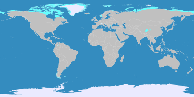
English: This map shows the Earth zones with a polar climate.
Ice cap climate
Tundra climate
Deutsch: Diese Karte stellt die polare Eisklimazone der Erde dar.
Eisklima
Tundrenklima |
| Datum | |
| Boarne |
English: Own work on the basis of the following data: Deutsch: Selbst erstellt auf Basis dieser Geodaten:
|
| Auteur | LordToran |
| Tastimming (Reusing this file) |
|
| Oare ferzjes |
 |
Lisinsje
This file is licensed under the Creative Commons Attribution-Share Alike 3.0 Unported license.
- Fiel jo frij:
- te dielen – it wurk te kopiearjen, fersprieden en út te stjoeren
- te fermingen – it wurk oan te passen
- Under de neikommende betingsten:
- Nammefermelding – You must give appropriate credit, provide a link to the license, and indicate if changes were made. You may do so in any reasonable manner, but not in any way that suggests the licensor endorses you or your use.
- Lyk diele – If you remix, transform, or build upon the material, you must distribute your contributions under the same or compatible license as the original.
Triemskiednis
Klik op in datum/tiid om it bestân te besjen sa't it op dat stuit wie.
| Datum/Tiid | Miniatuer | ôfmjittings | Meidogger | Opmerking | |
|---|---|---|---|---|---|
| lêste | 11 okt 2016, 23.07 | | 3.600 × 1.800 (674 KB) | Maphobbyist | The Caspian Sea was omitted. The Köppen system is based on the concept that climate types are correlated with the natural vegetation. |
| 15 okt 2007, 17.17 |  | 3.600 × 1.800 (569 KB) | Lortordermur | ||
| 5 jun 2007, 22.46 |  | 3.445 × 1.731 (617 KB) | Lortordermur | == Beschreibung == {{Information |Description=Diese Karte stellt die polare Klimazone der Erde dar. {{legend|#eaeaff|Eisklima}} {{legend|#19ebed|Tundrenklima}} |Source=Selbst erstellt auf Basis [http://www.copernicus.org/EGU/hess/hessd/4/439/hessd-4-439 |
Bestânsgebrûk
De neikommende side brûkt dit bestân:
Globaal bestânsgebrûk
De neikommende oare wiki's brûke dit bestân:
- Gebrûk op bg.wikipedia.org
- Gebrûk op he.wikipedia.org
- Gebrûk op hr.wikipedia.org
- Gebrûk op hy.wikipedia.org
- Gebrûk op lb.wikipedia.org
- Gebrûk op ru.wikipedia.org