Ofbyld:Klimagürtel-der-erde-tropen.png

Grutte fan dit proefbyld: 800 × 400 piksels. Oare resolúsjes: 320 × 160 piksels | 640 × 320 piksels | 1.024 × 512 piksels | 1.280 × 640 piksels | 3.600 × 1.800 piksels.
Oarspronklik bestân (3.600 × 1.800 pixels, bestânsgrutte: 685 KB, MIME-type: image/png)

|
This meteorology image could be re-created using vector graphics as an SVG file. This has several advantages; see Commons:Media for cleanup for more information. If an SVG form of this image is available, please upload it and afterwards replace this template with
{{vector version available|new image name}}.
It is recommended to name the SVG file “Klimagürtel-der-erde-tropen.svg”—then the template Vector version available (or Vva) does not need the new image name parameter. |
Gearfetting
| Beskriuwing |
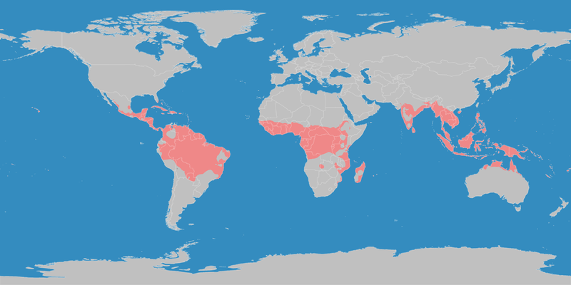
English: This map shows the Earth zones with tropical climate. Deutsch: Diese Karte stellt die tropische Klimazone der Erde dar. |
| Datum | |
| Boarne |
English: Own work on the basis of the following data: Deutsch: Selbst erstellt auf Basis dieser Geodaten:
|
| Auteur | LordToran |
| Tastimming (Reusing this file) |
|
| Oare ferzjes |
 |
Lisinsje
This file is licensed under the Creative Commons Attribution-Share Alike 3.0 Unported license.
- Fiel jo frij:
- te dielen – it wurk te kopiearjen, fersprieden en út te stjoeren
- te fermingen – it wurk oan te passen
- Under de neikommende betingsten:
- Nammefermelding – You must give appropriate credit, provide a link to the license, and indicate if changes were made. You may do so in any reasonable manner, but not in any way that suggests the licensor endorses you or your use.
- Lyk diele – If you remix, transform, or build upon the material, you must distribute your contributions under the same or compatible license as the original.
Triemskiednis
Klik op in datum/tiid om it bestân te besjen sa't it op dat stuit wie.
| Datum/Tiid | Miniatuer | ôfmjittings | Meidogger | Opmerking | |
|---|---|---|---|---|---|
| lêste | 11 okt 2016, 23.13 | | 3.600 × 1.800 (685 KB) | Maphobbyist | The Caspian Sea was omitted. The Köppen system is based on the concept that climate types are correlated with the natural vegetation. |
| 15 okt 2007, 17.26 |  | 3.600 × 1.800 (585 KB) | Lortordermur | ||
| 5 jun 2007, 22.49 |  | 3.445 × 1.731 (628 KB) | Lortordermur | == Beschreibung == {{Information |Description=Diese Karte stellt die tropische Klimazone der Erde dar. |Source=Selbst erstellt auf Basis [http://www.copernicus.org/EGU/hess/hessd/4/439/hessd-4-439.htm dieser Karte], welche unter einer Creative-Commons-Li |
Bestânsgebrûk
De neikommende side brûkt dit bestân:
Globaal bestânsgebrûk
De neikommende oare wiki's brûke dit bestân:
- Gebrûk op als.wikipedia.org
- Gebrûk op de.wikiversity.org
- Gebrûk op dsb.wikipedia.org
- Gebrûk op en.wikipedia.org
- Gebrûk op en.wikivoyage.org
- Gebrûk op hsb.wikipedia.org
- Gebrûk op ja.wikipedia.org
- Gebrûk op ko.wikipedia.org
- Gebrûk op mk.wikipedia.org
- Gebrûk op nl.wikipedia.org
- Gebrûk op ro.wikipedia.org
- Gebrûk op sr.wikipedia.org
- Gebrûk op sv.wikipedia.org
- Gebrûk op tr.wikipedia.org
- Gebrûk op vi.wikipedia.org
- Gebrûk op zh.wikipedia.org