Ofbyld:Le Castellet circuit map Formula One 2018 without corner names English 29 06 2021.svg

Oarspronklik bestân(SVG-bestân, nominaal 2.191 × 1.951 pixels, bestânsgrutte: 59 KB)

Dit bestân komt fan Wikimedia Commons, en kin ek troch oare projekten brûkt wurde. De beskriuwing op syn bestânsside dêre wurdt hjirûnder werjûn.

Gearfetting

Beskriuwing
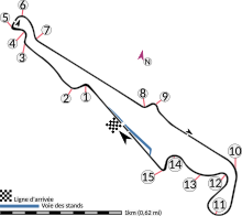
English: This is an altered version of File:Le Castellet circuit map Formula One 2018 without corner names June 2021.svg with the key solely in English and a few other alterations. This is a map of the Le Castellet motor circuit as it was used by w:en:Formula One for the w:en:2018 French Grand Prix, before the pit lane entrances and exits were reconfigured, and includes corner numbers and other information sourced from the FIA's map of the circuit. This map is valid for races which use this layout and corner numbering scheme, please upload a new file for races which use different layouts or corner numbering schemes rather than replacing this file. As this is a free-hand map drawn by an enthusiast rather than a professional cartographer's work it may contain some errors, although checking it against other maps it appears accurate enough for most purposes. The track is shown in black with a grey outline, while the pit lane is shown in blue. A scale showing the length of one kilometre (with increments of 100 metres) is given, to allow viewers to contextualise and understand what they are looking at. Corner numbers and other important text is given an off-white background to avoid transparency issues rendering it illegible on certain devices. A thick white line covering the track and the pit lane, marked with a chequered flag, shows the location of the start/finish line, also known as the control or timing line. A thinner white line, covering only the track, shows the location of pole position, and is marked with a large black arrow indicating the direction of travel. There are also thin white lines crossing the track which indicate the ends of the first and second timing sectors used by Formula One; these are marked with smaller black arrows, which also indicate the direction of travel. The mauve arrow marked "N" shows the direction of north.
 
Arrow pointing north
 
Pit lane
 
Links corner number to location of corner
Datum
Boarne Eigen wurk
Auteur HumanBodyPiloter5
Oare ferzjes
The 2019 layout, after the pitlane was modified
Une version française
A version of the map with the key in multiple languages and other minor differences

Lisinsje

I, the copyright holder of this work, hereby publish it under the following license:
Creative Commons CC-Zero This file is made available under the Creative Commons CC0 1.0 Universal Public Domain Dedication.
The person who associated a work with this deed has dedicated the work to the public domain by waiving all of their rights to the work worldwide under copyright law, including all related and neighboring rights, to the extent allowed by law. You can copy, modify, distribute and perform the work, even for commercial purposes, all without asking permission.

Captions

Add a one-line explanation of what this file represents
A map of the Le Castellet motor circuit as it was used by Formula One for the 2018 French Grand Prix

Items portrayed in this file

depicts Ingelsk

inception Ingelsk

29 jun 2021

Triemskiednis

Klik op in datum/tiid om it bestân te besjen sa't it op dat stuit wie.

Datum/TiidMiniatuerôfmjittingsMeidoggerOpmerking
lêste29 jun 2021, 03.15Miniatuer foar de ferzje fan 29 jun 2021 om 03.152.191 × 1.951 (59 KB)HumanBodyPiloter5Uploaded own work with UploadWizard

De neikommende side brûkt dit bestân:

Globaal bestânsgebrûk

Metadata