Ofbyld:Leeuwarden-topografie.jpg
Grutte fan dit proefbyld: 615 × 599 piksels. Oare resolúsjes: 246 × 240 piksels | 493 × 480 piksels | 788 × 768 piksels | 1.051 × 1.024 piksels | 1.910 × 1.861 piksels.
Oarspronklik bestân (1.910 × 1.861 pixels, bestânsgrutte: 2,31 MB, MIME-type: image/jpeg)
Gearfetting
| Beskriuwing |
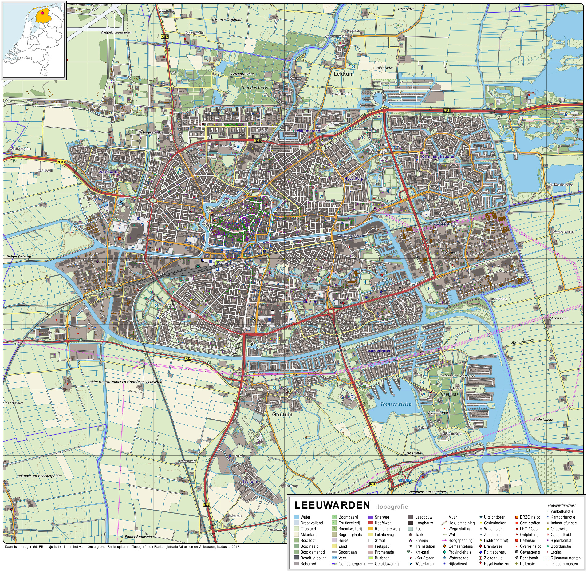
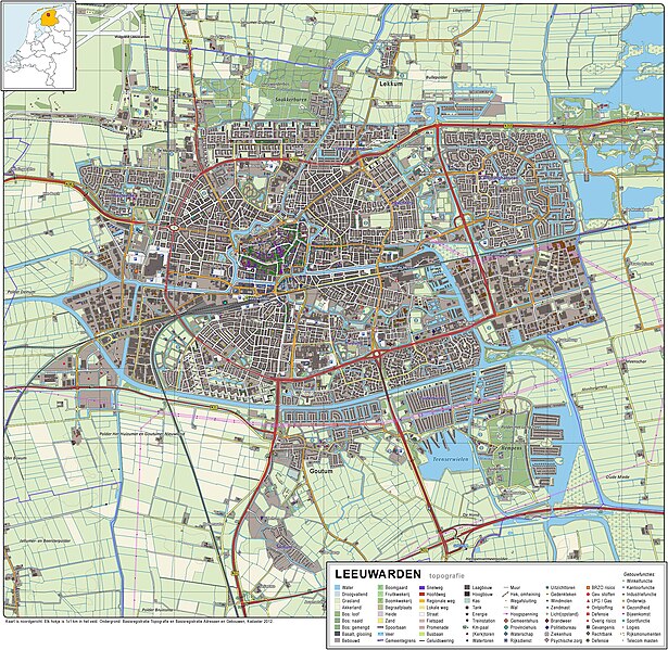
Nederlands: Topografisch beeld van de stad Leeuwarden (Ljouwert).
Op basis van de GML open geodata van de BRT/Top10NL (basisregistratie Topografie, Kadaster 2012), vrijgegeven door Kadaster op 30-11-2012 onder de Creative Commons BY licentie. Gebouwvlakken vanuit Open Geodata BAG extract (december 2012). Samenstelling en kleurenschema: Jan-Willem van Aalst. |
| Datum | |
| Boarne | Eigen wurk |
| Auteur | Janwillemvanaalst |
Lisinsje
I, the copyright holder of this work, hereby publish it under the following license:
This file is licensed under the Creative Commons Attribution-Share Alike 3.0 Unported license.
- Fiel jo frij:
- te dielen – it wurk te kopiearjen, fersprieden en út te stjoeren
- te fermingen – it wurk oan te passen
- Under de neikommende betingsten:
- Nammefermelding – You must give appropriate credit, provide a link to the license, and indicate if changes were made. You may do so in any reasonable manner, but not in any way that suggests the licensor endorses you or your use.
- Lyk diele – If you remix, transform, or build upon the material, you must distribute your contributions under the same or compatible license as the original.
Triemskiednis
Klik op in datum/tiid om it bestân te besjen sa't it op dat stuit wie.
| Datum/Tiid | Miniatuer | ôfmjittings | Meidogger | Opmerking | |
|---|---|---|---|---|---|
| lêste | 15 jan 2013, 21.52 | | 1.910 × 1.861 (2,31 MB) | Janwillemvanaalst | Added various topographic improvements, which were already available in the BRT open-geodata source files: - Symbols for special physical appearances of land types such as "swampy terrain" - Symbol for carpool parking + large open parking spaces (in ad... |
| 5 jan 2013, 21.34 |  | 1.910 × 1.861 (2,18 MB) | Janwillemvanaalst | Various rendering improvements, following the advice of several topographic experts. Scale remains unchanged. | |
| 30 des 2012, 15.03 |  | 1.910 × 1.861 (2,14 MB) | Janwillemvanaalst | Map redrawn using updated (Dec. 2012) open geodata Dutch government base registries BRT + BAG. Rendered using QuantumGIS and Photoshop. | |
| 16 mrt 2012, 17.26 |  | 3.267 × 2.681 (3,08 MB) | Janwillemvanaalst | Building polygons now taken from Open Geodata BAG registry (Jan. 2012); increased image resolution. | |
| 11 feb 2012, 21.10 |  | 2.244 × 1.773 (2,07 MB) | Janwillemvanaalst | Added car parking features; plus improved zoom level | |
| 8 feb 2012, 08.21 |  | 2.022 × 1.597 (1,75 MB) | Janwillemvanaalst | Color layout improvements on buildings. | |
| 5 feb 2012, 19.12 |  | 2.022 × 1.597 (1,75 MB) | Janwillemvanaalst |
Bestânsgebrûk
De neikommende side brûkt dit bestân: