Ofbyld:LocationLiechtenstein.png
Gjin hegere resolúsje beskikber.
LocationLiechtenstein.png (250 × 115 pixels, bestânsgrutte: 6 KB, MIME-type: image/png)
Gearfetting
| Beskriuwing |
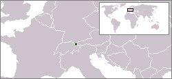
English: Location map for Liechtenstein.
Deutsch: Karte zur Lage von Liechtenstein. |
|||
| Datum | ||||
| Boarne | Originally created for English Wikipedia by Vardion. | |||
| Auteur | Vardion | |||
| Oare ferzjes |
|


Lisinsje
| |
This work has been released into the public domain by its author, Vardion, at the Ingelsk Wikipedy project. This applies worldwide. In case this is not legally possible: |
| Annotations | This image is annotated: View the annotations at Commons |
Triemskiednis
Klik op in datum/tiid om it bestân te besjen sa't it op dat stuit wie.
| Datum/Tiid | Miniatuer | ôfmjittings | Meidogger | Opmerking | |
|---|---|---|---|---|---|
| lêste | 16 des 2004, 07.59 | | 250 × 115 (6 KB) | EugeneZelenko | Location map for the Liechtenstein.<br/>Originally created for English Wikipedia by Vardion.<br/>{{PD}}<br/>Category:Country locator maps |
| 12 des 2004, 17.11 |  | 250 × 115 (6 KB) | SpeedyGonsales | Location Liechtenstein |
Bestânsgebrûk
It neikommendbestân is identyk oan dit bestân (mear bysûnderheden):
De neikommende side brûkt dit bestân:
Globaal bestânsgebrûk
De neikommende oare wiki's brûke dit bestân:
- Gebrûk op als.wikipedia.org
- Gebrûk op arc.wikipedia.org
- Gebrûk op av.wikipedia.org
- Gebrûk op bg.wikipedia.org
- Gebrûk op bpy.wikipedia.org
- Gebrûk op br.wikipedia.org
- Gebrûk op ceb.wikipedia.org
- Gebrûk op ckb.wikipedia.org
- Gebrûk op cv.wikipedia.org
- Gebrûk op de.wikipedia.org
- Gebrûk op de.wikibooks.org
- Gebrûk op de.wikinews.org
- Gebrûk op de.wiktionary.org
- Gebrûk op dsb.wikipedia.org
- Gebrûk op el.wiktionary.org
- Gebrûk op en.wikipedia.org
- Gebrûk op en.wikivoyage.org
- Gebrûk op en.wiktionary.org
- Gebrûk op eo.wikipedia.org
- Gebrûk op eo.wiktionary.org
- Gebrûk op eu.wiktionary.org
- Gebrûk op fa.wikipedia.org
- Gebrûk op fiu-vro.wikipedia.org
- Gebrûk op fr.wikipedia.org
- Gebrûk op fr.wikinews.org
- Gebrûk op gu.wikipedia.org
- Gebrûk op he.wikivoyage.org
- Gebrûk op hif.wikipedia.org
- Gebrûk op ht.wikipedia.org
- Gebrûk op ia.wikipedia.org
- Gebrûk op id.wikipedia.org
- Gebrûk op incubator.wikimedia.org
- Gebrûk op it.wikivoyage.org
- Gebrûk op ja.wikipedia.org
- Gebrûk op jv.wikipedia.org
- Gebrûk op ka.wiktionary.org
- Gebrûk op kk.wikipedia.org
Mear globaal gebrûk fan dit bestân besjen.