Ofbyld:Louisiana1921Map.jpg

Grutte fan dit proefbyld: 800 × 581 piksels. Oare resolúsjes: 320 × 232 piksels | 640 × 465 piksels | 1.024 × 743 piksels | 1.171 × 850 piksels.
Oarspronklik bestân (1.171 × 850 pixels, bestânsgrutte: 497 KB, MIME-type: image/jpeg)
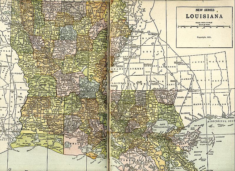
Scanned from "New Pictorial Atlas of the World" by George Wharton James and Alan H. Burgoyne, 1921 John Thomas
This work is in the public domain in the United States because it was published (or registered with the U.S. Copyright Office) before January 1, 1929.
Public domain works must be out of copyright in both the United States and in the source country of the work in order to be hosted on the Commons. If the work is not a U.S. work, the file must have an additional copyright tag indicating the copyright status in the source country.
Note: This tag should not be used for sound recordings. |
Triemskiednis
Klik op in datum/tiid om it bestân te besjen sa't it op dat stuit wie.
| Datum/Tiid | Miniatuer | ôfmjittings | Meidogger | Opmerking | |
|---|---|---|---|---|---|
| lêste | 21 nov 2004, 03.14 | | 1.171 × 850 (497 KB) | Infrogmation | Map of Louisiana, 1921. PD-US |
Bestânsgebrûk
De neikommende side brûkt dit bestân:
Globaal bestânsgebrûk
De neikommende oare wiki's brûke dit bestân:
- Gebrûk op ca.wikipedia.org