Ofbyld:Map of Alpine Glaciations.png

Grutte fan dit proefbyld: 800 × 512 piksels. Oare resolúsjes: 320 × 205 piksels | 640 × 410 piksels | 1.026 × 657 piksels.
Oarspronklik bestân (1.026 × 657 pixels, bestânsgrutte: 1,43 MB, MIME-type: image/png)

|
This geology image could be re-created using vector graphics as an SVG file. This has several advantages; see Commons:Media for cleanup for more information. If an SVG form of this image is available, please upload it and afterwards replace this template with
{{vector version available|new image name}}.
It is recommended to name the SVG file “Map of Alpine Glaciations.svg”—then the template Vector version available (or Vva) does not need the new image name parameter. |
| Beskriuwing |
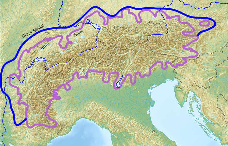
Deutsch: Ungefähre Ausdehnung der Vereisungen in den Alpen English: Approximate extent of alpine glaciations |
| Datum | (UTC) |
| Boarne |
|
| Auteur |
|
| This is a retouched picture, which means that it has been digitally altered from its original version. Modifications: Limits of alpine ice sheets, cropped black border. The original can be viewed here: Alps location map.png:
|
I, the copyright holder of this work, hereby publish it under the following licenses:
| This file is licensed under the Creative Commons Attribution-Share Alike 3.0 Unported license. | ||
| ||
| This licensing tag was added to this file as part of the GFDL licensing update. |

|
Der wurdt tastimming jûn ta kopiearjen, fersprieden en/of wizigjen fan dit dokumint ûnder de betinksten fan de GNU-lisinsje foar iepen dokumintaasje, ferzje 1.2, as eltse lettere ferzje útjûn troch de Free Software Foundation; sûnder Ynfariante Seksjes, sûnder Omkaftteksten foar de Foarkante en sûnder Omkaftteksten foar de Efterkante. In kopy fan de lisinsje is opnaam yn de seksje "Text of the GNU Free Documentation License". |
You may select the license of your choice.
The map has been created with the Generic Mapping Tools: https://www.generic-mapping-tools.org/ using one or more of these public-domain datasets for the relief:
|
|
|
Der wurdt tastimming jûn ta kopiearjen, fersprieden en/of wizigjen fan dit dokumint ûnder de betinksten fan de GNU-lisinsje foar iepen dokumintaasje, ferzje 1.2, as eltse lettere ferzje útjûn troch de Free Software Foundation; sûnder Ynfariante Seksjes, sûnder Omkaftteksten foar de Foarkante en sûnder Omkaftteksten foar de Efterkante. In kopy fan de lisinsje is opnaam yn de seksje "Text of the GNU Free Documentation License". |
Original upload log
This image is a derivative work of the following images:
- File:Alps_location_map.png licensed with Cc-by-sa-3.0-migrated, GFDL-GMT
- 2009-02-20T12:58:57Z Lencer 2000x1381 (4957657 Bytes) {{Information |Description= {{de|Positionskarte der [[:de:Alpen|Alpen]]}} Quadratische Plattkarte. Geographische Begrenzung der Karte: * N: 48.5 ° N * S: 42.75 ° N * W: 4.5 ° O * O: 17 ° O {{en|Location map of the
Uploaded with derivativeFX
Triemskiednis
Klik op in datum/tiid om it bestân te besjen sa't it op dat stuit wie.
| Datum/Tiid | Miniatuer | ôfmjittings | Meidogger | Opmerking | |
|---|---|---|---|---|---|
| lêste | 10 feb 2010, 22.00 | | 1.026 × 657 (1,43 MB) | Jo Weber | {{Information |Description={{de|Ausdehnung der Vereisungen Alpen}} {{en|Extent of alpine glciations}} |Source=*File:Alps_location_map.png and following sources: * Rudolf Hohl (Hrsg.): Die Entwicklungsgeschichte der Erde. 6. Auflage. W |
Bestânsgebrûk
De neikommende side brûkt dit bestân:
Globaal bestânsgebrûk
De neikommende oare wiki's brûke dit bestân:
- Gebrûk op ar.wikipedia.org
- Gebrûk op az.wikipedia.org
- Gebrûk op be.wikipedia.org
- Gebrûk op ca.wikipedia.org
- Gebrûk op de.wikipedia.org
- Gebrûk op de.wiktionary.org
- Gebrûk op en.wikipedia.org
- Last Glacial Period
- Last Interglacial
- Würm glaciation
- Mindel glaciation
- Riss glaciation
- Late Pleistocene
- Holstein interglacial
- Gunz (geology)
- Template:Alpine glaciations
- Danube (geology)
- Haslach glaciation
- Biber (geology)
- Biber-Danube interglacial
- Danube-Gunz interglacial
- Gunz-Haslach interglacial
- Haslach-Mindel interglacial
- Climate of France
- Gebrûk op es.wikipedia.org
- Gebrûk op es.wikibooks.org
- Gebrûk op fa.wikipedia.org
- Gebrûk op fi.wikipedia.org
- Gebrûk op fr.wikipedia.org
- Gebrûk op it.wikipedia.org
- Gebrûk op it.wikibooks.org
- Gebrûk op ka.wikipedia.org
Mear globaal gebrûk fan dit bestân besjen.