Ofbyld:Map of the Habsburg Netherlands by Alexis-Marie Gochet.png
Grutte fan dit proefbyld: 429 × 600 piksels. Oare resolúsjes: 171 × 240 piksels | 532 × 744 piksels.
Oarspronklik bestân (532 × 744 pixels, bestânsgrutte: 813 KB, MIME-type: image/png)

|
This old map image could be re-created using vector graphics as an SVG file. This has several advantages; see Commons:Media for cleanup for more information. If an SVG form of this image is available, please upload it and afterwards replace this template with
{{vector version available|new image name}}.
It is recommended to name the SVG file “Map of the Habsburg Netherlands by Alexis-Marie Gochet.svg”—then the template Vector version available (or Vva) does not need the new image name parameter. |
Gearfetting
| Beskriuwing |
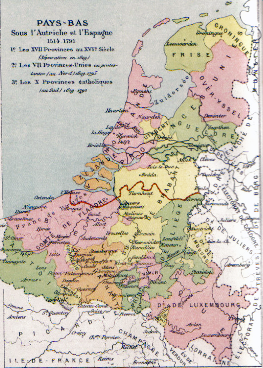
English: Map of the Habsburg Netherlands. Français : Carte des Pays-Bas des Habsbourg Nederlands: Map van de Habsburgse Nederlanden. |
||||||||||||||||||||
| Datum | Circa 1878 | ||||||||||||||||||||
| Boarne | Scan from Atlas de géographie physique, politique et historique à l'usage de l'enseignement primaire et de l'enseignement moyen, Dessain, Liège, 35e éd., s.d., p. 40. | ||||||||||||||||||||
| Auteur |
|
||||||||||||||||||||

Lisinsje
|
This work is in the public domain in its country of origin and other countries and areas where the copyright term is the author's life plus 100 years or fewer. This work is in the public domain in the United States because it was published (or registered with the U.S. Copyright Office) before January 1, 1929. | |
| This file has been identified as being free of known restrictions under copyright law, including all related and neighboring rights. | |
| Annotations | This image is annotated: View the annotations at Commons |
Triemskiednis
Klik op in datum/tiid om it bestân te besjen sa't it op dat stuit wie.
| Datum/Tiid | Miniatuer | ôfmjittings | Meidogger | Opmerking | |
|---|---|---|---|---|---|
| lêste | 25 des 2009, 02.32 | | 532 × 744 (813 KB) | Paul2 | somewhat lighter colours |
| 25 des 2009, 00.53 |  | 532 × 744 (865 KB) | Paul2 | Colours enhanced | |
| 31 okt 2005, 13.12 |  | 532 × 744 (927 KB) | BrightRaven | Map of the Spanish, then Austrian Netherlands. Author: MG Alexis |
Bestânsgebrûk
De neikommende 2 siden brûke dit bestân:
Globaal bestânsgebrûk
De neikommende oare wiki's brûke dit bestân:
- Gebrûk op ast.wikipedia.org
- Gebrûk op be.wikipedia.org
- Gebrûk op br.wikipedia.org
- Gebrûk op ca.wikipedia.org
- Gebrûk op cs.wikipedia.org
- Gebrûk op da.wikipedia.org
- Gebrûk op de.wikipedia.org
- Gebrûk op el.wikipedia.org
- Gebrûk op en.wikipedia.org
- Gebrûk op en.wikibooks.org
- Gebrûk op eo.wikipedia.org
- Gebrûk op et.wikipedia.org
- Gebrûk op eu.wikipedia.org
- Gebrûk op fa.wikipedia.org
- Gebrûk op fr.wikipedia.org
- Histoire de la Belgique
- Histoire du Luxembourg
- Pays-Bas espagnols
- Gravelines
- Pays-Bas méridionaux
- Duché de Luxembourg
- Histoire de la Wallonie avant 1830
- Discussion:Duché de Luxembourg
- Territoires du royaume de France
- Juan d'Aguila
- Pays-Bas des Habsbourg
- Portail:Histoire militaire de la Belgique/Bac à sable
- Wikipédia:Statistiques des anecdotes de la page d'accueil/Visibilité des anecdotes (2018)
- Discussion:Duché de Luxembourg/LSV 15996
- Wikipédia:Statistiques des anecdotes de la page d'accueil/Visibilité des anecdotes (2018)/2018 10
- Projet:Aide et accueil/Twitter/Tweets/archives/octobre 2018
- Protestantisme aux Pays-Bas
Mear globaal gebrûk fan dit bestân besjen.