Ofbyld:Missouri River basin map.png

Grutte fan dit proefbyld: 800 × 575 piksels. Oare resolúsjes: 320 × 230 piksels | 640 × 460 piksels | 1.024 × 736 piksels | 1.280 × 920 piksels | 1.496 × 1.075 piksels.
Oarspronklik bestân (1.496 × 1.075 pixels, bestânsgrutte: 2,63 MB, MIME-type: image/png)
Gearfetting
| Beskriuwing |
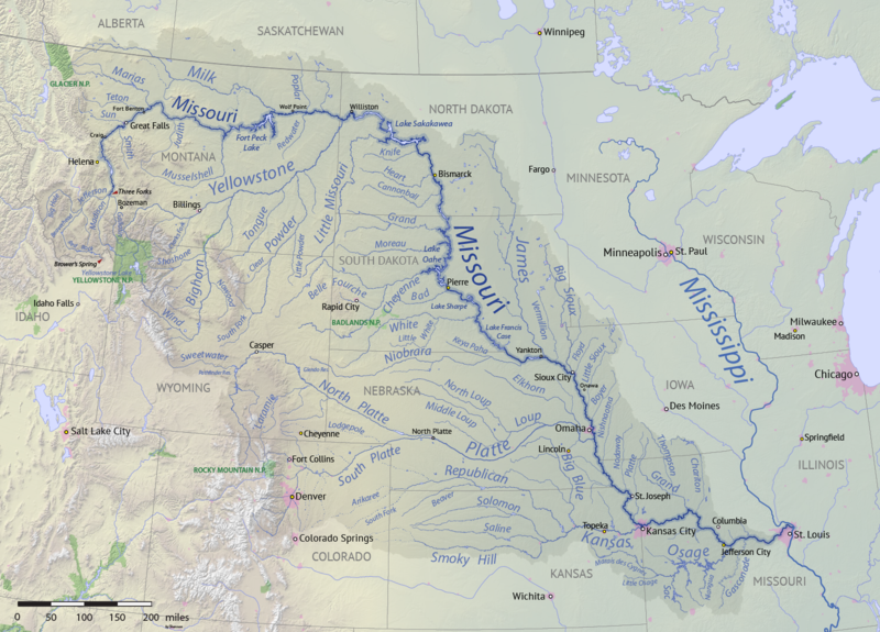
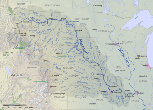
English: Map of the Missouri River drainage basin in the US and Canada. made using USGS and Natural Earth data. Replacement for File:Missouririvermap.jpg. |
| Datum | |
| Boarne | Eigen wurk |
| Auteur | Shannon1 |
.png)
Lisinsje
I, the copyright holder of this work, hereby publish it under the following licenses:

|
Der wurdt tastimming jûn ta kopiearjen, fersprieden en/of wizigjen fan dit dokumint ûnder de betinksten fan de GNU-lisinsje foar iepen dokumintaasje, ferzje 1.2, as eltse lettere ferzje útjûn troch de Free Software Foundation; sûnder Ynfariante Seksjes, sûnder Omkaftteksten foar de Foarkante en sûnder Omkaftteksten foar de Efterkante. In kopy fan de lisinsje is opnaam yn de seksje "Text of the GNU Free Documentation License". |
This file is licensed under the Creative Commons Attribution-Share Alike 4.0 International, 3.0 Unported, 2.5 Generic, 2.0 Generic and 1.0 Generic license.
- Fiel jo frij:
- te dielen – it wurk te kopiearjen, fersprieden en út te stjoeren
- te fermingen – it wurk oan te passen
- Under de neikommende betingsten:
- Nammefermelding – You must give appropriate credit, provide a link to the license, and indicate if changes were made. You may do so in any reasonable manner, but not in any way that suggests the licensor endorses you or your use.
- Lyk diele – If you remix, transform, or build upon the material, you must distribute your contributions under the same or compatible license as the original.
You may select the license of your choice.
Triemskiednis
Klik op in datum/tiid om it bestân te besjen sa't it op dat stuit wie.
| Datum/Tiid | Miniatuer | ôfmjittings | Meidogger | Opmerking | |
|---|---|---|---|---|---|
| lêste | 9 apr 2018, 02.15 | | 1.496 × 1.075 (2,63 MB) | Shannon1 | missing label |
| 30 mrt 2018, 23.56 |  | 1.500 × 1.080 (2,8 MB) | Shannon1 | slight fixes | |
| 30 mrt 2018, 21.30 |  | 1.500 × 1.078 (2,78 MB) | Shannon1 | {{Information |description ={{en|1=Map of the Missouri River drainage basin in the US and Canada. made using USGS and Natural Earth data. Replacement for File:Missouririvermap.jpg.}} |source =Own work |author =Shannon1 |date =2018-03-21 }} Category:Missouri River |
Bestânsgebrûk
De neikommende 2 siden brûke dit bestân:
Globaal bestânsgebrûk
De neikommende oare wiki's brûke dit bestân:
- Gebrûk op af.wikipedia.org
- Gebrûk op azb.wikipedia.org
- Gebrûk op az.wiktionary.org
- Gebrûk op ba.wikipedia.org
- Gebrûk op be.wikipedia.org
- Gebrûk op bh.wikipedia.org
- Gebrûk op bn.wikipedia.org
- Gebrûk op ca.wikipedia.org
- Gebrûk op cv.wikipedia.org
- Gebrûk op da.wikipedia.org
- Gebrûk op en.wikipedia.org
- Missouri River
- Grand River (South Dakota)
- User:Shannon1/Sandbox 5
- User:Shannon1/Maps
- Yellowstone expedition
- List of longest rivers of the United States (by main stem)
- List of tributaries of the Missouri River
- Wikipedia:Graphics Lab/Map workshop/Archive/Jul 2011
- List of dams in the Missouri River watershed
- User:Shannon1/Maps/to-do
- Joseph LaBarge
- Spread Eagle (steamboat)
- Emilie (steamboat)
- Gebrûk op es.wikipedia.org
- Iowa
- Dakota del Norte
- Dakota del Sur
- Denver
- Río Misuri
- Bismarck (Dakota del Norte)
- Misuri
- Río Yellowstone
- Lincoln (Nebraska)
- Omaha (Nebraska)
- Columbia (Misuri)
- Kansas City (Misuri)
- Topeka
- Río Marías
- Kansas City (Kansas)
- Río Cheyenne
- Río Gallatin
- Great Falls (Montana)
- Río Platte
- Río Milk
- Río James (Dakotas)
- Río Smoky Hill
- Río Saline (Kansas)
- Río Niobrara
Mear globaal gebrûk fan dit bestân besjen.