Ofbyld:New 2000 black percent.gif

Grutte fan dit proefbyld: 776 × 600 piksels. Oare resolúsjes: 311 × 240 piksels | 621 × 480 piksels | 994 × 768 piksels | 1.280 × 989 piksels | 2.604 × 2.012 piksels.
Oarspronklik bestân (2.604 × 2.012 pixels, bestânsgrutte: 649 KB, MIME-type: image/gif)
Gearfetting

|
This ethnographic map image could be re-created using vector graphics as an SVG file. This has several advantages; see Commons:Media for cleanup for more information. If an SVG form of this image is available, please upload it and afterwards replace this template with
{{vector version available|new image name}}.
It is recommended to name the SVG file “New 2000 black percent.svg”—then the template Vector version available (or Vva) does not need the new image name parameter. |
| Beskriuwing |
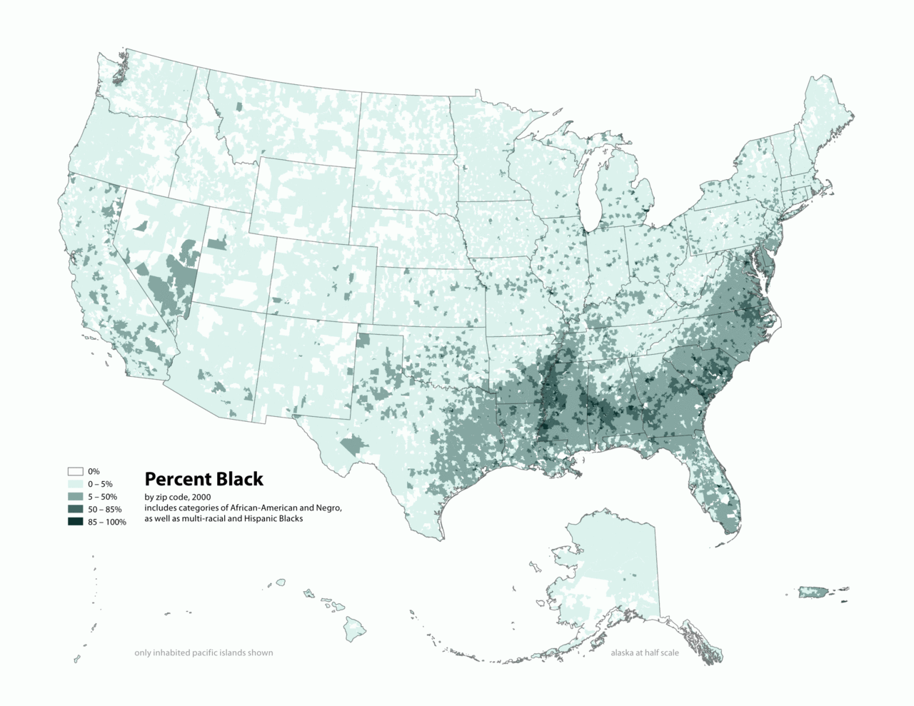
English: Map of contiguous US, showing percentage of population self-reported as "Black," by census tract, 2000. Data source: US Census. |
| Datum | 3 april 2006 (original upload date) |
| Boarne | Transferred from en.wikipedia to Commons by O'Dea. |
| Auteur | The original uploader was Citynoise at Ingelsk Wikipedy. |
Lisinsje
This file is licensed under the Creative Commons Attribution-Share Alike 2.5 Generic license.
- Fiel jo frij:
- te dielen – it wurk te kopiearjen, fersprieden en út te stjoeren
- te fermingen – it wurk oan te passen
- Under de neikommende betingsten:
- Nammefermelding – You must give appropriate credit, provide a link to the license, and indicate if changes were made. You may do so in any reasonable manner, but not in any way that suggests the licensor endorses you or your use.
- Lyk diele – If you remix, transform, or build upon the material, you must distribute your contributions under the same or compatible license as the original.
Original upload log
The original description page was here. All following user names refer to en.wikipedia.
- 2010-05-01 19:15 Citynoise 2604×2012× (664072 bytes) Added Alaska, Hawaii, and Territories. Also changed from tracts to zip codes.
- 2006-04-03 02:04 Citynoise 1012×691× (78990 bytes) Map of contiguous US, showing percentage of population self-reported as "Black," by census tract, 2000. Data source: US Census. I am the designer and creator of this map and license it under the Creative Commons Attribution ShareAlike 2.5 License. s
Category:Census maps of the United States Category:Maps illustrating African American history Category:African American history
Triemskiednis
Klik op in datum/tiid om it bestân te besjen sa't it op dat stuit wie.
| Datum/Tiid | Miniatuer | ôfmjittings | Meidogger | Opmerking | |
|---|---|---|---|---|---|
| lêste | 31 des 2011, 04.48 | | 2.604 × 2.012 (649 KB) | Spideog | {{Information |Description={{en|en:Category:Census maps of the United States en:Category:Maps illustrating African American history en:Category:African American history}} |Source=Transferred from [http://en.wikipedia.org en.wikipedia]; t |
Bestânsgebrûk
De neikommende side brûkt dit bestân:
Globaal bestânsgebrûk
De neikommende oare wiki's brûke dit bestân:
- Gebrûk op af.wikipedia.org
- Gebrûk op ar.wikipedia.org
- Gebrûk op cs.wikipedia.org
- Gebrûk op de.wikipedia.org
- Gebrûk op diq.wikipedia.org
- Gebrûk op en.wikipedia.org
- Gebrûk op fa.wikipedia.org
- Gebrûk op fr.wikipedia.org
- Gebrûk op he.wikipedia.org
- Gebrûk op ht.wikipedia.org
- Gebrûk op lfn.wikipedia.org
- Gebrûk op pt.wikipedia.org
- Gebrûk op ro.wikipedia.org
- Gebrûk op ru.wikipedia.org
- Gebrûk op test.wikipedia.org
- Gebrûk op tl.wikipedia.org
- Gebrûk op ur.wikipedia.org
- Gebrûk op uz.wikipedia.org