Ofbyld:Pearlmap2.png
Grutte fan dit proefbyld: 440 × 599 piksels. Oare resolúsjes: 176 × 240 piksels | 352 × 480 piksels | 564 × 768 piksels | 752 × 1.024 piksels | 1.292 × 1.760 piksels.
Oarspronklik bestân (1.292 × 1.760 pixels, bestânsgrutte: 409 KB, MIME-type: image/png)

|
This map image could be re-created using vector graphics as an SVG file. This has several advantages; see Commons:Media for cleanup for more information. If an SVG form of this image is available, please upload it and afterwards replace this template with
{{vector version available|new image name}}.
It is recommended to name the SVG file “Pearlmap2.svg”—then the template Vector version available (or Vva) does not need the new image name parameter. |
Gearfetting
| Beskriuwing |
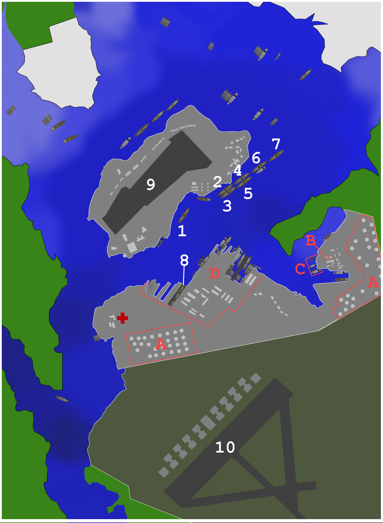
Map of ships and port facilities in Pearl Harbor during the attack. This text based legend is preferred: <21 ft
22-23 ft
29 ft
30-32 ft
33-34 ft
34-35 ft
36-37 ft
38-39 ft
40-41 ft
42-48 ft
>49 ft
City
Army base
Navy base
|
| Datum | (UTC) |
| Boarne | Own work using: map from http://www.navsource.org/Naval/ as a reference. |
| Auteur | Anynobody |
| Oare ferzjes |
|


Lisinsje
I, the copyright holder of this work, hereby publish it under the following licenses:

|
Der wurdt tastimming jûn ta kopiearjen, fersprieden en/of wizigjen fan dit dokumint ûnder de betinksten fan de GNU-lisinsje foar iepen dokumintaasje, ferzje 1.2, as eltse lettere ferzje útjûn troch de Free Software Foundation; sûnder Ynfariante Seksjes, sûnder Omkaftteksten foar de Foarkante en sûnder Omkaftteksten foar de Efterkante. In kopy fan de lisinsje is opnaam yn de seksje "Text of the GNU Free Documentation License". |
This file is licensed under the Creative Commons Attribution-Share Alike 3.0 Unported, 2.5 Generic, 2.0 Generic and 1.0 Generic license.
- Fiel jo frij:
- te dielen – it wurk te kopiearjen, fersprieden en út te stjoeren
- te fermingen – it wurk oan te passen
- Under de neikommende betingsten:
- Nammefermelding – You must give appropriate credit, provide a link to the license, and indicate if changes were made. You may do so in any reasonable manner, but not in any way that suggests the licensor endorses you or your use.
- Lyk diele – If you remix, transform, or build upon the material, you must distribute your contributions under the same or compatible license as the original.
You may select the license of your choice.
Triemskiednis
Klik op in datum/tiid om it bestân te besjen sa't it op dat stuit wie.
| Datum/Tiid | Miniatuer | ôfmjittings | Meidogger | Opmerking | |
|---|---|---|---|---|---|
| lêste | 2 feb 2015, 15.40 | | 1.292 × 1.760 (409 KB) | RokerHRO | optipng -o7 -i0 → 12.59% decrease |
| 16 nov 2007, 04.39 |  | 1.292 × 1.760 (468 KB) | Anynobody~commonswiki | ||
| 8 nov 2007, 01.55 |  | 1.292 × 1.760 (629 KB) | Anynobody~commonswiki | ||
| 26 okt 2007, 07.32 |  | 1.292 × 1.760 (675 KB) | Anynobody~commonswiki | w/approx depth, hospital, and seaplane base buildings | |
| 26 okt 2007, 05.39 |  | 1.290 × 1.752 (289 KB) | Anynobody~commonswiki | ||
| 26 okt 2007, 05.37 |  | 1.292 × 1.760 (289 KB) | Anynobody~commonswiki | {{Information |Description=Map of ships and facilities at Pearl Harbor during the attack. |Source=self-made |Date= ~~~~~ |Author= Anynobody }} Category:Anynobody |
Bestânsgebrûk
De neikommende side brûkt dit bestân:
Globaal bestânsgebrûk
De neikommende oare wiki's brûke dit bestân:
- Gebrûk op ar.wikipedia.org
- Gebrûk op ast.wikipedia.org
- Gebrûk op cs.wikipedia.org
- Gebrûk op de.wikipedia.org
- Gebrûk op en.wikipedia.org
- Gebrûk op es.wikipedia.org
- Gebrûk op he.wikipedia.org
- Gebrûk op hu.wikipedia.org
- Gebrûk op it.wikipedia.org
- Gebrûk op ja.wikipedia.org
- Gebrûk op nl.wikipedia.org
- Gebrûk op pt.wikipedia.org
- Gebrûk op sv.wikipedia.org
- Gebrûk op uk.wikipedia.org
- Gebrûk op vi.wikipedia.org
- Gebrûk op zh.wikipedia.org