Ofbyld:Percentage population undernourished world map.PNG

Grutte fan dit proefbyld: 800 × 362 piksels. Oare resolúsjes: 320 × 145 piksels | 640 × 289 piksels | 1.237 × 559 piksels.
Oarspronklik bestân (1.237 × 559 pixels, bestânsgrutte: 161 KB, MIME-type: image/png)
Gearfetting
| Beskriuwing |
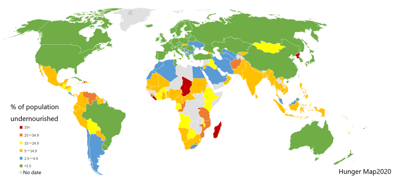
English: List of countries by percentage of population suffering from undernourishment. Made by jp:User:Fnweirkmnwperojvnu, using Map of Excel. The map has been updated (on 2021-01-11) according to the "Hunger Map 2020" from the United Nations World Food Programme.
Sources: Sustainable Development Goal indicators website "Global SDG Indicators Database>GOLE2 End hunger, achieve food security and improved nutrition and promote sustainable agriculture": https://unstats.un.org/sdgs/indicators/database/?indicator=2.1.1 United Nations World Food Programme's interactive "hunger map": http://cdn.wfp.org/hungermap/ Hunger Map 2020: https://www.wfp.org/publications/hunger-map-2020 |
| Datum | 11 jannewaris 2021 (original upload date) |
| Boarne | Transferred from en.wikipedia to Commons. |
| Auteur | The original uploader was Fnweirkmnwperojvnu at jp Wikipedy. |
| Oare ferzjes |
Derivative works of this file: Percentage population undernourished world map-ar.PNG  |


|
This map image could be re-created using vector graphics as an SVG file. This has several advantages; see Commons:Media for cleanup for more information. If an SVG form of this image is available, please upload it and afterwards replace this template with
{{vector version available|new image name}}.
It is recommended to name the SVG file “Percentage population undernourished world map.svg”—then the template Vector version available (or Vva) does not need the new image name parameter. |
Lisinsje

|
Der wurdt tastimming jûn ta kopiearjen, fersprieden en/of wizigjen fan dit dokumint ûnder de betinksten fan de GNU-lisinsje foar iepen dokumintaasje, ferzje 1.2, as eltse lettere ferzje útjûn troch de Free Software Foundation; sûnder Ynfariante Seksjes, sûnder Omkaftteksten foar de Foarkante en sûnder Omkaftteksten foar de Efterkante. In kopy fan de lisinsje is opnaam yn de seksje "Text of the GNU Free Documentation License". |
| This file is licensed under the Creative Commons Attribution-Share Alike 3.0 Unported license. | ||
| ||
| This licensing tag was added to this file as part of the GFDL licensing update. |
Original upload log
The original description page was here. All following user names refer to en.wikipedia.
- 2007-03-23 02:31 Lobizón 1355×768×8 (58226 bytes) List of countries by percentage of population suffering from undernourishment. Made from Wikipedia's "map of the world" template, using information from the United Nations World Food Programme and the FAO "The State of Food Insecurity in the World 2006" r
Triemskiednis
Klik op in datum/tiid om it bestân te besjen sa't it op dat stuit wie.
| Datum/Tiid | Miniatuer | ôfmjittings | Meidogger | Opmerking | |
|---|---|---|---|---|---|
| lêste | 10 jan 2021, 18.31 | | 1.237 × 559 (161 KB) | Fnweirkmnwperojvnu | data updates |
| 18 jul 2020, 23.07 |  | 1.357 × 628 (47 KB) | Maphobbyist | South Sudan border | |
| 16 apr 2016, 20.30 |  | 1.357 × 628 (46 KB) | Kontrollstellekundl | updated according to the "Hunger Map 2013" http://documents.wfp.org/stellent/groups/public/documents/communications/wfp229327.pdf | |
| 28 feb 2016, 14.20 |  | 1.357 × 628 (45 KB) | Kontrollstellekundl | cropped | |
| 15 aug 2015, 16.08 |  | 1.355 × 768 (46 KB) | Jamie Tubers | update | |
| 31 des 2013, 06.38 |  | 1.355 × 768 (56 KB) | Varitia | Small correction on Indonesia | |
| 31 des 2013, 06.19 |  | 1.355 × 768 (56 KB) | Varitia | Update to 2012 figures and parameters according to the United Nations World Food Programme | |
| 5 mai 2008, 01.04 |  | 1.355 × 768 (56 KB) | Dwrcan | Updates. (Note: click on the actual countries of the source map, the actual data sometimes doesn't match the color of the country.) | |
| 10 nov 2007, 23.00 |  | 1.355 × 768 (57 KB) | Béka~commonswiki | {{Information |Description={{en|List of countries by percentile of population suffering from undernourishment. Made by en:User:Lobizón, using Wikipedia's "map of the world" template, and information from the United Nations World Food Programme and t |
Bestânsgebrûk
De neikommende side brûkt dit bestân:
Globaal bestânsgebrûk
De neikommende oare wiki's brûke dit bestân:
- Gebrûk op af.wikipedia.org
- Gebrûk op ast.wikipedia.org
- Gebrûk op ba.wikipedia.org
- Gebrûk op bg.wikipedia.org
- Gebrûk op bn.wikipedia.org
- Gebrûk op cs.wikipedia.org
- Gebrûk op cv.wikipedia.org
- Gebrûk op de.wikipedia.org
- Gebrûk op en.wikipedia.org
- Gebrûk op en.wikinews.org
- Gebrûk op eo.wikipedia.org
- Gebrûk op es.wikipedia.org
- Gebrûk op es.wikinews.org
- Gebrûk op eu.wikipedia.org
- Gebrûk op fa.wikipedia.org
- Gebrûk op fi.wikipedia.org
- Gebrûk op gu.wikipedia.org
- Gebrûk op he.wikipedia.org
- Gebrûk op hr.wikipedia.org
- Gebrûk op hu.wikipedia.org
- Gebrûk op hy.wikipedia.org
- Gebrûk op id.wikipedia.org
- Gebrûk op is.wikipedia.org
- Gebrûk op it.wikipedia.org
- Gebrûk op ja.wikipedia.org
- Gebrûk op kn.wikipedia.org
- Gebrûk op la.wikipedia.org
- Gebrûk op lmo.wikipedia.org
- Gebrûk op lt.wikipedia.org
- Gebrûk op lv.wikipedia.org
Mear globaal gebrûk fan dit bestân besjen.