Ofbyld:Roman.Britain.Romanisation.jpg
Grutte fan dit proefbyld: 566 × 599 piksels. Oare resolúsjes: 227 × 240 piksels | 453 × 480 piksels | 725 × 768 piksels | 967 × 1.024 piksels | 1.934 × 2.048 piksels | 3.000 × 3.176 piksels.
Oarspronklik bestân (3.000 × 3.176 pixels, bestânsgrutte: 924 KB, MIME-type: image/jpeg)
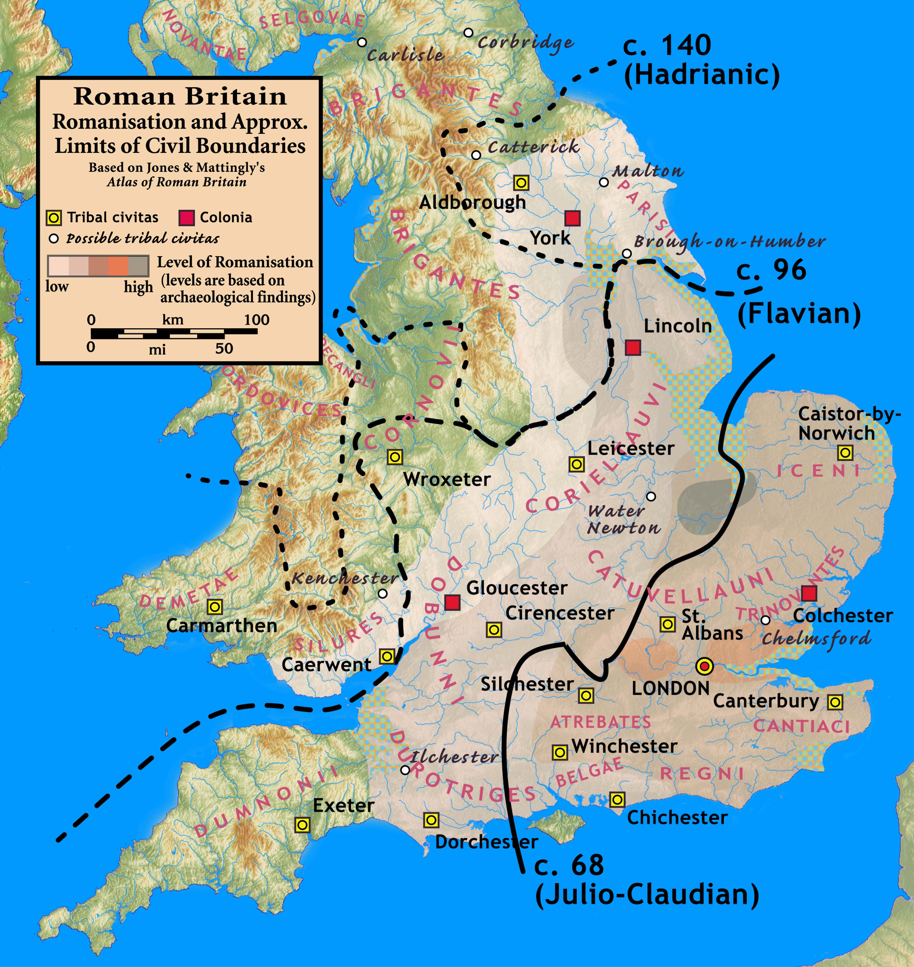
| Beskriuwing | Roman Britain — Levels of Romanisation and Approximate Limits of Civil Boundaries |
| Datum | |
| Boarne |
Based on Jones & Mattingly's Atlas of Roman Britain (ISBN 978-1-84217-06700, 1990, reprinted 2007) — the source is cited in the image legend — Approximate civil boundaries, civitates, and coloniae are given on page 154. Levels of Romanisation ("boundaries of acculturation" with levels from "high density" to "low density" in the text) are given on page 151, with the authors citing it as a computer-generated map based on data contained in the standard Ordnance Survey map of Roman Britain. |
| Auteur | my work |
I, the copyright holder of this work, hereby publish it under the following license:
This file is licensed under the Creative Commons Attribution-Share Alike 3.0 Unported license.
- Fiel jo frij:
- te dielen – it wurk te kopiearjen, fersprieden en út te stjoeren
- te fermingen – it wurk oan te passen
- Under de neikommende betingsten:
- Nammefermelding – You must give appropriate credit, provide a link to the license, and indicate if changes were made. You may do so in any reasonable manner, but not in any way that suggests the licensor endorses you or your use.
- Lyk diele – If you remix, transform, or build upon the material, you must distribute your contributions under the same or compatible license as the original.
Triemskiednis
Klik op in datum/tiid om it bestân te besjen sa't it op dat stuit wie.
| Datum/Tiid | Miniatuer | ôfmjittings | Meidogger | Opmerking | |
|---|---|---|---|---|---|
| lêste | 9 sep 2010, 03.12 | | 3.000 × 3.176 (924 KB) | Notuncurious | {{Information |Description= Roman Britain — Levels of Romanisation and Approximate Limits of Civil Boundaries |Source=Based on Jones & Mattingly's ''Atlas of Roman Britain'' (ISBN 978-1-84217-06700, 1990, reprinted 2007) — the source is cited |
Bestânsgebrûk
De neikommende side brûkt dit bestân:
Globaal bestânsgebrûk
De neikommende oare wiki's brûke dit bestân:
- Gebrûk op af.wikipedia.org
- Gebrûk op ar.wikipedia.org
- Gebrûk op ast.wikipedia.org
- Gebrûk op bn.wikipedia.org
- Gebrûk op ca.wikipedia.org
- Gebrûk op en.wikipedia.org
- Gebrûk op es.wikipedia.org
- Gebrûk op fa.wikipedia.org
- Gebrûk op fr.wikipedia.org
- Gebrûk op hr.wikipedia.org
- Gebrûk op id.wikipedia.org
- Gebrûk op it.wikipedia.org
- Gebrûk op ja.wikipedia.org
- Gebrûk op ms.wikipedia.org
- Gebrûk op nl.wikipedia.org
- Gebrûk op nn.wikipedia.org
- Gebrûk op no.wikipedia.org
- Gebrûk op ro.wikipedia.org
- Gebrûk op ru.wikipedia.org
- Gebrûk op sh.wikipedia.org
- Gebrûk op tr.wikipedia.org
- Gebrûk op uk.wikipedia.org
- Gebrûk op zh.wikipedia.org