Ofbyld:Satellite image of Guinea-Bissau in January 2003.jpg

Grutte fan dit proefbyld: 800 × 490 piksels. Oare resolúsjes: 320 × 196 piksels | 640 × 392 piksels | 1.024 × 627 piksels | 1.361 × 833 piksels.
Oarspronklik bestân (1.361 × 833 pixels, bestânsgrutte: 169 KB, MIME-type: image/jpeg)
Gearfetting
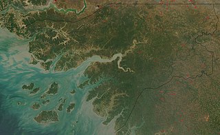
| Beskriuwing | Satellite image of Guinea-Bissau in January 2003. |
| Datum | |
| Boarne | Cropped from original: http://visibleearth.nasa.gov/view_rec.php?id=4841 |
| Auteur | Jacques Descloitres, MODIS Rapid Response Team, NASA/GSFC |
The Islands are known as Bijagos Archipelago, in English, Bissagos in portuguese, one of them, nearest to the coast towards the centre of the image, furthest to the East being Bolama
Lisinsje
| This file is in the public domain in the United States because it was solely created by NASA. NASA copyright policy states that "NASA material is not protected by copyright unless noted". (See Template:PD-USGov, NASA copyright policy page or JPL Image Use Policy.) | ||
 |
Warnings:
|
Triemskiednis
Klik op in datum/tiid om it bestân te besjen sa't it op dat stuit wie.
| Datum/Tiid | Miniatuer | ôfmjittings | Meidogger | Opmerking | |
|---|---|---|---|---|---|
| lêste | 22 des 2004, 15.47 | | 1.361 × 833 (169 KB) | Hautala | {{PD-USGov-NASA}} Satellite image of Guinea-Bissau in January 2003. Cropped image, original taken from NASA's Visible Earth http://visibleearth.nasa.gov/cgi-bin/viewrecord?23921 |
Bestânsgebrûk
De neikommende side brûkt dit bestân:
Globaal bestânsgebrûk
De neikommende oare wiki's brûke dit bestân:
- Gebrûk op af.wikipedia.org
- Gebrûk op ar.wikipedia.org
- Gebrûk op azb.wikipedia.org
- Gebrûk op ca.wikipedia.org
- Gebrûk op de.wikipedia.org
- Gebrûk op en.wikipedia.org
- Gebrûk op es.wikipedia.org
- Gebrûk op fa.wikipedia.org
- Gebrûk op fr.wikipedia.org
- Gebrûk op hif.wikipedia.org
- Gebrûk op hu.wiktionary.org
- Gebrûk op it.wikipedia.org
- Gebrûk op nl.wikipedia.org
- Gebrûk op or.wikipedia.org
- Gebrûk op pt.wikipedia.org
- Gebrûk op ru.wikipedia.org
- Gebrûk op simple.wikipedia.org
- Gebrûk op sq.wikibooks.org
- Gebrûk op uk.wikipedia.org
- Gebrûk op yi.wikipedia.org