Ofbyld:Satellite image of Lauwersmeer, Netherlands (6.21E 53.36N).png

Grutte fan dit proefbyld: 800 × 548 piksels. Oare resolúsjes: 320 × 219 piksels | 640 × 439 piksels | 1.024 × 702 piksels.
Oarspronklik bestân (1.024 × 702 pixels, bestânsgrutte: 1,15 MB, MIME-type: image/png)
.png)
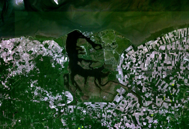
Satellite image of the Lauwersmeer, The Netherlands. This image was made with World Wind.
| This image is in the public domain because it is a screenshot from NASA’s globe software World Wind using a public domain layer, such as Blue Marble, MODIS, Landsat, SRTM, USGS or GLOBE.
|
 |
Triemskiednis
Klik op in datum/tiid om it bestân te besjen sa't it op dat stuit wie.
| Datum/Tiid | Miniatuer | ôfmjittings | Meidogger | Opmerking | |
|---|---|---|---|---|---|
| lêste | 3 mai 2005, 22.18 | | 1.024 × 702 (1,15 MB) | Galwaygirl | Satellite image of the Lauwersmeer, The Netherlands. This image was made with World Wind. {{PD}} |
Bestânsgebrûk
De neikommende side brûkt dit bestân:
Globaal bestânsgebrûk
De neikommende oare wiki's brûke dit bestân:
- Gebrûk op ar.wikipedia.org
- Gebrûk op da.wikipedia.org
- Gebrûk op de.wikipedia.org
- Gebrûk op en.wikipedia.org
- Gebrûk op eo.wikipedia.org
- Gebrûk op fr.wikipedia.org
- Gebrûk op it.wikipedia.org
- Gebrûk op nds-nl.wikipedia.org
- Gebrûk op nl.wikipedia.org
- Gebrûk op nn.wikipedia.org
- Gebrûk op pl.wikipedia.org
- Gebrûk op ru.wikipedia.org
.png)