Ofbyld:Scandinavia-12th century.png
Grutte fan dit proefbyld: 507 × 599 piksels. Oare resolúsjes: 203 × 240 piksels | 406 × 480 piksels | 650 × 768 piksels | 866 × 1.024 piksels | 1.650 × 1.950 piksels.
Oarspronklik bestân (1.650 × 1.950 pixels, bestânsgrutte: 340 KB, MIME-type: image/png)
Gearfetting
| Beskriuwing | |
| Boarne | Eigen wurk |
| Auteur | Ningyou at Finsk Wikipedy |

|
Ofbyld:Scandinavia-12th century.svg is in fektorferzje fan dizze triem. As net fan sljochtere kwaliteit tsjinnet dizze brûkt te wurden yn plak fan dizze rasterôfbylding.
File:Scandinavia-12th century.png → File:Scandinavia-12th century.svg
Sjoch Help:SVG foar mear ynformaasje. |
 |
Lisinsje
| I, the copyright holder of this work, release this work into the public domain. This applies worldwide. In some countries this may not be legally possible; if so: I grant anyone the right to use this work for any purpose, without any conditions, unless such conditions are required by law. |
Triemskiednis
Klik op in datum/tiid om it bestân te besjen sa't it op dat stuit wie.
| Datum/Tiid | Miniatuer | ôfmjittings | Meidogger | Opmerking | |
|---|---|---|---|---|---|
| lêste | 21 feb 2007, 21.19 | | 1.650 × 1.950 (340 KB) | Tene~commonswiki | Optimised (0) [Only tried 5 and 0] |
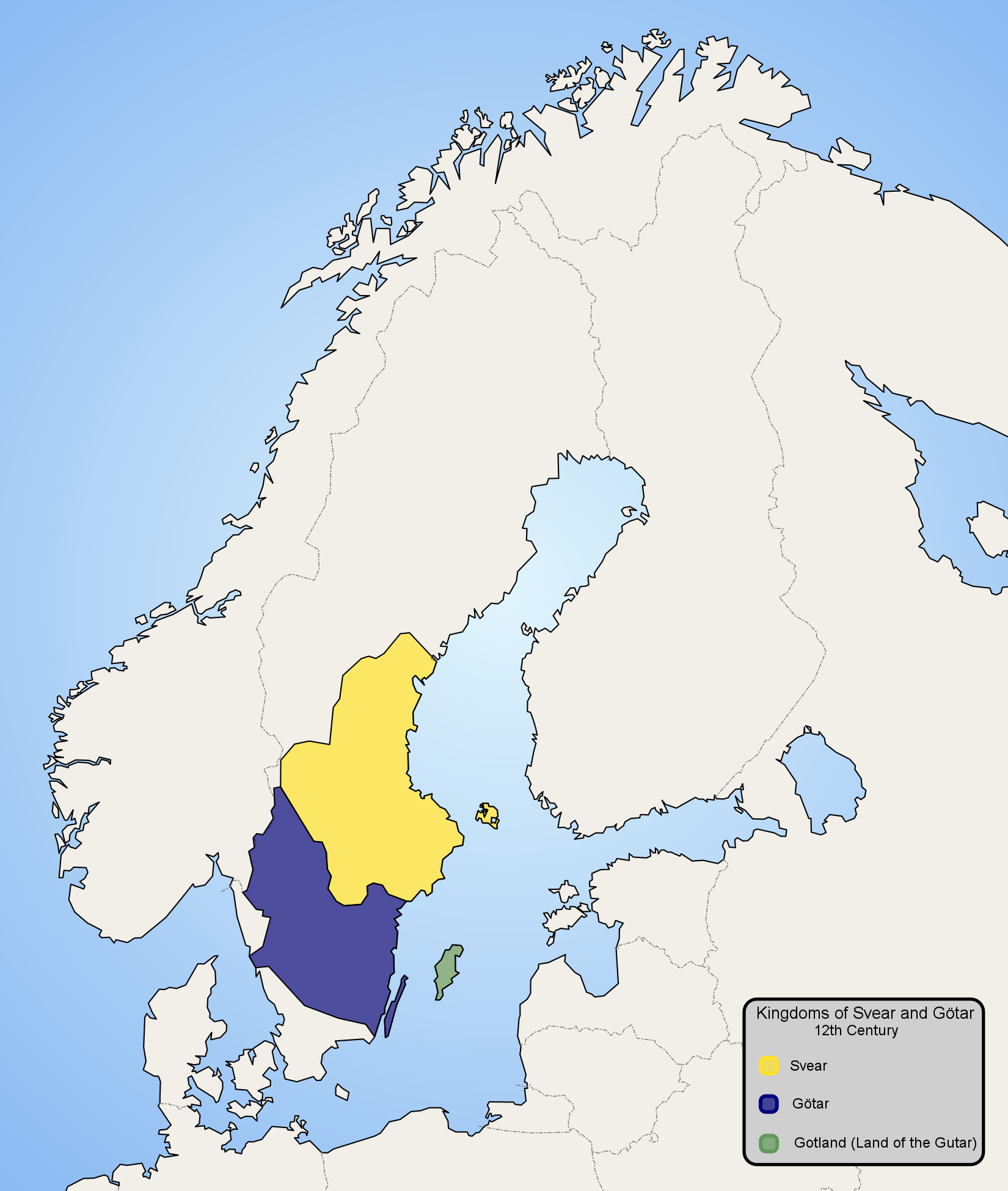
| 13 jan 2006, 23.57 |  | 1.650 × 1.950 (479 KB) | Ningyou | Map of Scandinavia in 12th century, showing modern borders in grey. Made by fi:Käyttäjä:Ningyou. Category:Maps of Sweden Category:Maps of Scandinavia |
Bestânsgebrûk
De neikommende 3 siden brûke dit bestân:
Globaal bestânsgebrûk
De neikommende oare wiki's brûke dit bestân:
- Gebrûk op af.wikipedia.org
- Gebrûk op am.wikipedia.org
- Gebrûk op ar.wikipedia.org
- Gebrûk op arz.wikipedia.org
- Gebrûk op ast.wikipedia.org
- Gebrûk op azb.wikipedia.org
- Gebrûk op az.wikipedia.org
- Gebrûk op be-tarask.wikipedia.org
- Gebrûk op be.wikipedia.org
- Gebrûk op bg.wikipedia.org
- Gebrûk op ca.wikipedia.org
- Gebrûk op ckb.wikipedia.org
- Gebrûk op cs.wikipedia.org
- Gebrûk op cv.wikipedia.org
- Gebrûk op da.wikipedia.org
- Gebrûk op de.wikipedia.org
- Gebrûk op en.wikipedia.org
- Gebrûk op en.wiktionary.org
- Gebrûk op eo.wikipedia.org
- Gebrûk op es.wikipedia.org
- Gebrûk op et.wikipedia.org
- Gebrûk op eu.wikipedia.org
- Gebrûk op fi.wikipedia.org
- Gebrûk op fr.wikipedia.org
- Gebrûk op gl.wikipedia.org
- Gebrûk op hu.wikipedia.org
- Gebrûk op it.wikipedia.org
.png)
Mear globaal gebrûk fan dit bestân besjen.