Ofbyld:Southwest map.png

Grutte fan dit proefbyld: 800 × 520 piksels. Oare resolúsjes: 320 × 208 piksels | 640 × 416 piksels | 1.024 × 666 piksels | 1.280 × 832 piksels.
Oarspronklik bestân (1.280 × 832 pixels, bestânsgrutte: 199 KB, MIME-type: image/png)
Gearfetting
| Beskriuwing |
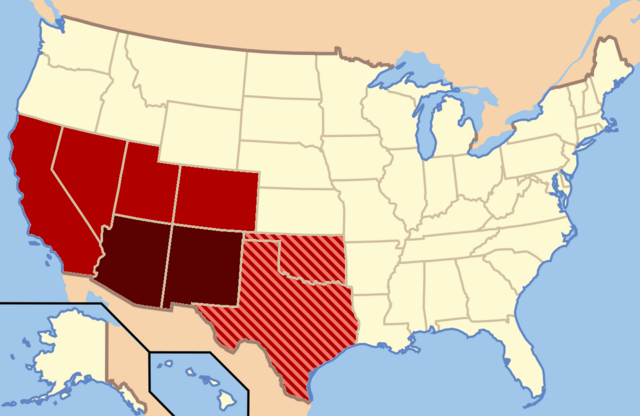
Dark Red: Almost always considered the Southwest |
| Datum | |
| Boarne | Eigen wurk |
| Auteur | Secret Saturdays |
Lisinsje
| I, the copyright holder of this work, release this work into the public domain. This applies worldwide. In some countries this may not be legally possible; if so: I grant anyone the right to use this work for any purpose, without any conditions, unless such conditions are required by law. |
Triemskiednis
Klik op in datum/tiid om it bestân te besjen sa't it op dat stuit wie.
| Datum/Tiid | Miniatuer | ôfmjittings | Meidogger | Opmerking | |
|---|---|---|---|---|---|
| lêste | 9 feb 2022, 05.20 | | 1.280 × 832 (199 KB) | Quackslikeaduck | Reverted to version as of 20:03, 25 August 2016 (UTC); Kansas is not considered part of the American Southwest, not even geographically. |
| 31 jul 2020, 23.39 |  | 1.280 × 832 (159 KB) | Rubensbathsheba | Kansas may sometimes be considered part of the Southwest geographically. | |
| 25 aug 2016, 22.03 |  | 1.280 × 832 (199 KB) | WClarke | Instead of using dark red, red, and blue stripes, this version uses dark red, red, and red stripes. Everything being red makes the map look more uniform. | |
| 24 jul 2009, 00.53 |  | 572 × 371 (21 KB) | Secret Saturdays | {{Information |Description={{en|1=The Dark Red states mean they are almost always considered Southwest states, The light red states mean they are rarely considered Southwest states and the Blue States mean they are conisdered Southwest and Southern states |
Bestânsgebrûk
De neikommende side brûkt dit bestân:
Globaal bestânsgebrûk
De neikommende oare wiki's brûke dit bestân:
- Gebrûk op ar.wikipedia.org
- Gebrûk op cs.wikipedia.org
- Gebrûk op de.wikipedia.org
- Gebrûk op en.wikipedia.org
- Gebrûk op eo.wikipedia.org
- Gebrûk op he.wikipedia.org
- Gebrûk op id.wikipedia.org
- Gebrûk op ko.wikipedia.org
- Gebrûk op ru.wikipedia.org
- Gebrûk op sv.wikipedia.org
- Gebrûk op tr.wikipedia.org
- Gebrûk op ur.wikipedia.org
- Gebrûk op vi.wikipedia.org
- Gebrûk op www.wikidata.org