Ofbyld:Topographic map of Gotland.svg

Size of this PNG preview of this SVG file: 491 × 599 piksels. Oare resolúsjes: 197 × 240 piksels | 393 × 480 piksels | 629 × 768 piksels | 839 × 1.024 piksels | 1.678 × 2.048 piksels | 1.337 × 1.632 piksels.
Oarspronklik bestân (SVG-bestân, nominaal 1.337 × 1.632 pixels, bestânsgrutte: 1,16 MB)
Gearfetting
This W3C-unspecified vector image was created with Inkscape .
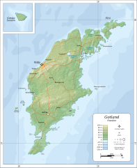
| Beskriuwing |
English: Topographic map of Gotland.
Suomi: Gotlannin topografinen kartta.
Svenska: En topografisk karta över Gotland. |
| Datum | |
| Boarne |
Self-made in Inkscape.
|
| Auteur | Oona Räisänen (Mysid) |
| Oare ferzjes |
|


|
This SVG file contains embedded text that can be translated into your language, using any capable SVG editor, text editor or the SVG Translate tool. For more information see: About translating SVG files. |
Lisinsje
I, the copyright holder of this work, hereby publish it under the following licenses:

|
Der wurdt tastimming jûn ta kopiearjen, fersprieden en/of wizigjen fan dit dokumint ûnder de betinksten fan de GNU-lisinsje foar iepen dokumintaasje, ferzje 1.2, as eltse lettere ferzje útjûn troch de Free Software Foundation; sûnder Ynfariante Seksjes, sûnder Omkaftteksten foar de Foarkante en sûnder Omkaftteksten foar de Efterkante. In kopy fan de lisinsje is opnaam yn de seksje "Text of the GNU Free Documentation License". |
This file is licensed under the Creative Commons Attribution-Share Alike 4.0 International, 3.0 Unported, 2.5 Generic, 2.0 Generic and 1.0 Generic license.
- Fiel jo frij:
- te dielen – it wurk te kopiearjen, fersprieden en út te stjoeren
- te fermingen – it wurk oan te passen
- Under de neikommende betingsten:
- Nammefermelding – You must give appropriate credit, provide a link to the license, and indicate if changes were made. You may do so in any reasonable manner, but not in any way that suggests the licensor endorses you or your use.
- Lyk diele – If you remix, transform, or build upon the material, you must distribute your contributions under the same or compatible license as the original.
You may select the license of your choice.
Triemskiednis
Klik op in datum/tiid om it bestân te besjen sa't it op dat stuit wie.
| Datum/Tiid | Miniatuer | ôfmjittings | Meidogger | Opmerking | |
|---|---|---|---|---|---|
| lêste | 6 aug 2010, 21.29 | | 1.337 × 1.632 (1,16 MB) | Mysid | fonts with better support |
| 6 aug 2010, 21.25 |  | 1.337 × 1.632 (1,16 MB) | Mysid | major remake from better sources | |
| 8 jul 2008, 15.39 |  | 635 × 1.023 (499 KB) | Smith609 | Correct spelling of BurgsviK | |
| 25 feb 2008, 19.43 |  | 635 × 1.023 (491 KB) | Mysid | roads | |
| 24 feb 2008, 18.10 |  | 635 × 1.023 (482 KB) | Mysid | {{inkscape}} {{Information |Description={{en|Topographic map of w:Gotland.}} {{fi|Gotlannin topografinen kartta.}} {{sv|En topografisk karta över sv:Gotland.}} |Source=Self-made in Inkscape.<br/>Boundaries and topography based |
Bestânsgebrûk
De neikommende side brûkt dit bestân:
Globaal bestânsgebrûk
De neikommende oare wiki's brûke dit bestân:
- Gebrûk op ar.wikipedia.org
- Gebrûk op ast.wikipedia.org
- Gebrûk op az.wikipedia.org
- Gebrûk op be-tarask.wikipedia.org
- Gebrûk op be.wikipedia.org
- Gebrûk op ce.wikipedia.org
- Gebrûk op cs.wikipedia.org
- Gebrûk op dsb.wikipedia.org
- Gebrûk op el.wikipedia.org
- Gebrûk op en.wikipedia.org
- Gebrûk op es.wikipedia.org
- Gebrûk op fi.wikipedia.org
- Gebrûk op fr.wikipedia.org
- Gebrûk op gl.wikipedia.org
- Gebrûk op hu.wikipedia.org
- Gebrûk op is.wikipedia.org
- Gebrûk op ja.wikipedia.org
- Gebrûk op ko.wikipedia.org
- Gebrûk op lt.wikipedia.org
- Gebrûk op mn.wikipedia.org
- Gebrûk op ms.wikipedia.org
- Gebrûk op os.wikipedia.org
- Gebrûk op pl.wikipedia.org
- Gebrûk op pl.wiktionary.org
- Gebrûk op ru.wikipedia.org
- Gebrûk op sr.wikipedia.org
- Gebrûk op sv.wikipedia.org
- Gebrûk op sw.wikipedia.org
- Gebrûk op vls.wikipedia.org