Ofbyld:Tunis Gulf topo map-fr.svg

Size of this PNG preview of this SVG file: 663 × 600 piksels. Oare resolúsjes: 265 × 240 piksels | 531 × 480 piksels | 849 × 768 piksels | 1.132 × 1.024 piksels | 2.264 × 2.048 piksels | 1.990 × 1.800 piksels.
Oarspronklik bestân (SVG-bestân, nominaal 1.990 × 1.800 pixels, bestânsgrutte: 2,58 MB)
Gearfetting
| Camera location | | View this and other nearby images on: OpenStreetMap |
|---|
| Beskriuwing |
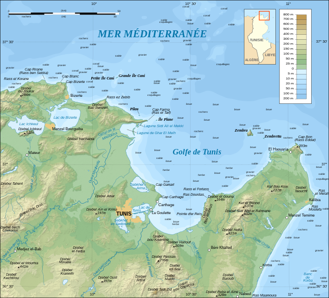
English: Topographic and bathymetric map in French of the Gulf of Tunis, Tunisia, with indication of the nature of the sea bottom.
Note: The shaded relief is a raster image embedded in the SVG file. Français : Carte topographique et bathymétrique en français du Golfe de Tunis, avec indication de la nature des fonds marins.
Note : Les ombres du relief sont une image bitmap embarquée dans le fichier SVG. UTM projection ; WGS84 datum ; shaded relief (composite image of N-W, W and N lightning positions) ; |
||
| Datum | |||
| Boarne |
Own work ;
|
||
| Auteur | Eric Gaba (Sting - fr:Sting) | ||
| Tastimming (Reusing this file) |
|
||
| Oare ferzjes |
[]
|


|
This SVG file contains embedded text that can be translated into your language, using any capable SVG editor, text editor or the SVG Translate tool. For more information see: About translating SVG files. |
Lisinsje
I, the copyright holder of this work, hereby publish it under the following licenses:

|
Der wurdt tastimming jûn ta kopiearjen, fersprieden en/of wizigjen fan dit dokumint ûnder de betinksten fan de GNU-lisinsje foar iepen dokumintaasje, ferzje 1.2, as eltse lettere ferzje útjûn troch de Free Software Foundation; sûnder Ynfariante Seksjes, sûnder Omkaftteksten foar de Foarkante en sûnder Omkaftteksten foar de Efterkante. In kopy fan de lisinsje is opnaam yn de seksje "Text of the GNU Free Documentation License". |
This file is licensed under the Creative Commons Attribution-Share Alike 3.0 Unported, 2.5 Generic, 2.0 Generic and 1.0 Generic license.
- Fiel jo frij:
- te dielen – it wurk te kopiearjen, fersprieden en út te stjoeren
- te fermingen – it wurk oan te passen
- Under de neikommende betingsten:
- Nammefermelding – You must give appropriate credit, provide a link to the license, and indicate if changes were made. You may do so in any reasonable manner, but not in any way that suggests the licensor endorses you or your use.
- Lyk diele – If you remix, transform, or build upon the material, you must distribute your contributions under the same or compatible license as the original.
You may select the license of your choice.
Triemskiednis
Klik op in datum/tiid om it bestân te besjen sa't it op dat stuit wie.
| Datum/Tiid | Miniatuer | ôfmjittings | Meidogger | Opmerking | |
|---|---|---|---|---|---|
| lêste | 1 sep 2008, 02.31 | | 1.990 × 1.800 (2,58 MB) | Sting | New standard colors |
| 26 okt 2007, 00.16 |  | 1.990 × 1.800 (2,57 MB) | Sting | Zembra / Zembretta islands correction ; + nature of the sea bottom indications | |
| 25 okt 2007, 22.42 |  | 1.990 × 1.800 (2,52 MB) | Sting | {{Information |Description=Topographic map in French of the Gulf of Tunis, Tunisia |Source=Own work ;<br/>Topographic map : [http://www2.jpl.nasa.gov/srtm NASA Shuttle Radar Topography Mission] (SRTM3 v.2) (public domain) edited with |
Bestânsgebrûk
De neikommende side brûkt dit bestân:
Globaal bestânsgebrûk
De neikommende oare wiki's brûke dit bestân:
- Gebrûk op de.wikipedia.org
- Gebrûk op en.wikipedia.org
- Gebrûk op es.wikipedia.org
- Gebrûk op fr.wikipedia.org
- Province d'Afrique
- Utilisateur:Pline/création article
- Liste des golfes de Tunisie
- Golfe de Tunis
- Utilisateur:Urban/cartes
- Site archéologique de Carthage
- Utilisateur:Pradigue/Byrsa
- Église du prêtre Félix et baptistère de Kélibia
- Wikipédia:Atelier graphique/Cartes/Archives/Demandes mises en sommeil/Monde
- Discussion utilisateur:Sting/Archive 17
- Phare de Sidi Bou Saïd
- Phare de Zembretta
- Phare du Cap Bon
- Gebrûk op he.wikipedia.org
- Gebrûk op hr.wikipedia.org
- Gebrûk op id.wikipedia.org
- Gebrûk op ja.wikipedia.org
- Gebrûk op ko.wikipedia.org
- Gebrûk op lt.wikipedia.org
- Gebrûk op mg.wikipedia.org
- Gebrûk op nl.wikipedia.org
- Gebrûk op no.wikipedia.org
- Gebrûk op oc.wikipedia.org
- Gebrûk op pl.wikipedia.org
- Gebrûk op pl.wiktionary.org
- Gebrûk op pt.wikipedia.org
- Gebrûk op sl.wikipedia.org
- Gebrûk op sv.wikipedia.org
- Gebrûk op zh.wikipedia.org