Ofbyld:WW2-Holocaust-ROstland.PNG
Gjin hegere resolúsje beskikber.
WW2-Holocaust-ROstland.PNG (442 × 418 pixels, bestânsgrutte: 145 KB, MIME-type: image/png)
Gearfetting
| Beskriuwing |
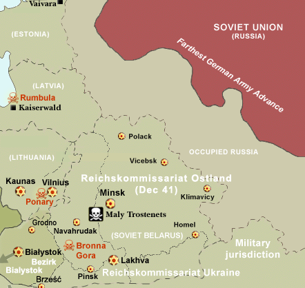
Map of the Holocaust in Reichskommissariat Ostland (Belarus and the Baltic States) during World War II, 1939-1945. This map shows all extermination camps (or death camps), most major concentration camps, labor camps, prison camps, ghettos, major deportation routes and major massacre sites. Notes: 1. Extermination camps were dedicated death camps, but all camps and ghettos took a toll of many, many lives. 2. Concentration camps include labor camps, prison camps & transit camps. 3. Not all camps & ghettos are shown. 4. Borders are at the height of Axis domination (1942). 5. Some regions have German designations (e.g. "Ostland"), with the present country name denoted in uppercase letters in parenthesis below the German designation (e.g. "(AUSTRIA)"). 6. Present (2007) borders are dotted. |
| Datum | (UTC) |
| Boarne | |
| Auteur | |
| Tastimming (Reusing this file) |
CC, see below. The map is completely unrestricted for any Wikipedia/Wikimedia project. |
| Oare ferzjes |
 Derivative works of this file: WW2-Holocaust-Poland.PNGImage:WW2-Holocaust-Europe-2007Borders.png (present (2007) borders). If you have any opinions/suggestions, please contact me here on my talk page. |

|
This historical map image could be re-created using vector graphics as an SVG file. This has several advantages; see Commons:Media for cleanup for more information. If an SVG form of this image is available, please upload it and afterwards replace this template with
{{vector version available|new image name}}.
It is recommended to name the SVG file “WW2-Holocaust-ROstland.svg”—then the template Vector version available (or Vva) does not need the new image name parameter. |
Lisinsje
I, Dennis Nilsson, the copyright holder of this work, hereby publishes it under the following license:
This file is licensed under the Creative Commons Attribution 3.0 Unported license.
Nammefermelding: I, Dennis Nilsson
- Fiel jo frij:
- te dielen – it wurk te kopiearjen, fersprieden en út te stjoeren
- te fermingen – it wurk oan te passen
- Under de neikommende betingsten:
- Nammefermelding – You must give appropriate credit, provide a link to the license, and indicate if changes were made. You may do so in any reasonable manner, but not in any way that suggests the licensor endorses you or your use.
- derivative work: Piotr Konieczny aka Prokonsul Piotrus Talk
|Permission= |other_versions= }}
| This is a retouched picture, which means that it has been digitally altered from its original version. Modifications: Belarus and Baltic States only. The original can be viewed here: WW2-Holocaust-Europe.png:
|
I, the copyright holder of this work, hereby publish it under the following license:
This file is licensed under the Creative Commons Attribution 3.0 Unported license.
- Fiel jo frij:
- te dielen – it wurk te kopiearjen, fersprieden en út te stjoeren
- te fermingen – it wurk oan te passen
- Under de neikommende betingsten:
- Nammefermelding – You must give appropriate credit, provide a link to the license, and indicate if changes were made. You may do so in any reasonable manner, but not in any way that suggests the licensor endorses you or your use.
Original upload log
This image is a derivative work of the following images:
- File:WW2-Holocaust-Europe.png licensed with Cc-by-3.0
- 2007-12-20T03:41:38Z Dna-webmaster 1310x1090 (845818 Bytes) new version without "Axis cooperating" in legend
- 2007-12-20T02:00:30Z Dna-webmaster 1310x1090 (844034 Bytes) Now entire West Prussia and Wartheland is included in the Third Reich
- 2007-12-19T16:42:15Z Dna-webmaster 1310x1090 (847461 Bytes) still not Da Vinci, but errors have been corrected (Germany borders West/East), West & East Prussia borders/coloring and Poland General Government corrected borders.
- 2007-12-17T10:46:28Z Dna-webmaster 1310x1090 (844633 Bytes) new map with 1942 borders, not Da Vinci, but here it goes...
- 2007-10-19T13:32:25Z Dna-webmaster 1310x1090 (784727 Bytes) and another update
- 2007-10-19T12:21:52Z Dna-webmaster 1310x1090 (789383 Bytes) quick fix
- 2007-10-19T12:11:07Z Dna-webmaster 1310x1090 (789413 Bytes) {{Information |Description=Map of the Holocaust in Europe during World War II, 1939-1945. This map shows all extermination camps (or ''death camps''), most major concentration camps, work camps, prison camps, ghettos, major
Uploaded with derivativeFX' '
Triemskiednis
Klik op in datum/tiid om it bestân te besjen sa't it op dat stuit wie.
| Datum/Tiid | Miniatuer | ôfmjittings | Meidogger | Opmerking | |
|---|---|---|---|---|---|
| lêste | 29 jul 2016, 18.51 | | 442 × 418 (145 KB) | Poeticbent | file reloaded, cache promblems |
| 29 jul 2016, 18.44 |  | 442 × 418 (145 KB) | Poeticbent | missing elements including locations | |
| 5 sep 2013, 21.25 |  | 442 × 418 (131 KB) | Poeticbent | most obvious error, Lithuania was never part of Reichskommissariat Ostland, neither was Bialystok, added names of major cities | |
| 2 nov 2009, 20.44 |  | 442 × 418 (90 KB) | Flying Saucer | Vaivara | |
| 19 feb 2009, 21.32 |  | 442 × 418 (90 KB) | Piotrus | {{Information |Description=Map of the Holocaust in Reichskommissariat Ostland (Belarus and the Baltic States) during World War II, 1939-1945. <br> This map shows all extermination camps (or ''death camps''), most major concentration camps, labor camps, pr |
Bestânsgebrûk
De neikommende 2 siden brûke dit bestân:
Globaal bestânsgebrûk
De neikommende oare wiki's brûke dit bestân:
- Gebrûk op be-tarask.wikipedia.org
- Gebrûk op da.wikipedia.org
- Gebrûk op de.wikipedia.org
- Gebrûk op el.wikipedia.org
- Gebrûk op en.wikipedia.org
- Gebrûk op es.wikipedia.org
- Gebrûk op fa.wikipedia.org
- Gebrûk op fi.wikipedia.org
- Gebrûk op fr.wikipedia.org
- Gebrûk op he.wikipedia.org
- Gebrûk op it.wikipedia.org
- Gebrûk op ja.wikipedia.org
- Gebrûk op mk.wikipedia.org
- Gebrûk op nl.wikipedia.org
- Gebrûk op no.wikipedia.org
- Gebrûk op pl.wikipedia.org
- Gebrûk op pt.wikipedia.org
- Gebrûk op ro.wikipedia.org
- Gebrûk op sr.wikipedia.org
- Gebrûk op sv.wikipedia.org
- Gebrûk op tr.wikipedia.org
- Gebrûk op vi.wikipedia.org
- Gebrûk op zh.wikipedia.org