Ofbyld:WW2 Holocaust Europe map-fr.svg

Oarspronklik bestân(SVG-bestân, nominaal 1.310 × 1.090 pixels, bestânsgrutte: 841 KB)

Render this image in .

Dit bestân komt fan Wikimedia Commons, en kin ek troch oare projekten brûkt wurde. De beskriuwing op syn bestânsside dêre wurdt hjirûnder werjûn.

Gearfetting

Beskriuwing
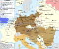
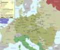
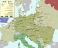
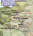
English: Map of the Holocaust in Europe during World War II, 1939-1945.
This map shows all extermination camps (or death camps), most major concentration camps, labor camps, prison camps, ghettos, major deportation routes and major massacre sites.
  1. Extermination camps were dedicated death camps, but all camps and ghettos took a toll of many, many lives.
  2. Concentration camps include labor camps, prison camps & transit camps.
  3. Not all camps & ghettos are shown.
  4. Borders are at the height of Axis domination (1942).
  5. Some regions have German designations (e.g. "Ostmark"), with the present country name denoted in uppercase letters in parenthesis below the German designation (e.g. "(Austria)").
  6. Previous borders (1920) are dotted in orange color.
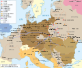
Français : Carte de la Shoah en Europe lors de la Seconde Guerre mondiale (1939-1945).
Cette carte montre tous les camps d'extermination (ou « camps de la mort ») et la plupart des principaux camps de concentration, de travail forcé, prisons, itinéraires de déportation et lieux de massacres.
Notes
  1. Les camps d'extermination étaient des lieux dédiés à la mise à mort, mais de nombreuses vies furent perdues également dans les ghettos et les autres camps.
  2. Les camps de concentration montrés ici incluent les camps de travail, les prisons et les lieux de transit.
  3. Tous les camps et ghettos ne sont pas indiqués.
  4. Les zones colorées montrent la situation géopolitique au maximum de la domination des puissances de l'Axe (1942).
  5. Certaines zones sont désignées avec leur nom allemand d'alors (par exemple « Ostmark »), mais leur nom actuel est indiqué dessous entre parenthèses (même exemple « (Autriche) »).
  6. Les frontières d'avant la guerre (1920) sont dessinées en pointillés oranges.
Català: Mapa de L'Holocaust a Europa durant la Segona Guerra Mundial, 1939-1945.
Notes
Datum (UTC)
Boarne
Auteur
Oare ferzjes

[bewurkje]

Jeropa 1942
Jeropa 2007
Poalen
Oekraïne
Reichskommissariat Ostland
Northeast Europe

Derivative works of this file:

Nammefermelding
(required by the license)
InfoField
© Sémhur / Wikimedia Commons / 
© Sémhur / Wikimedia Commons
SVG
InfoField
 
This W3C-unspecified vector image was created with Inkscape…important .
Translate this file This SVG file contains embedded text that can be translated into your language, using any capable SVG editor, text editor or the SVG Translate tool. For more information see: About translating SVG files.
This is a retouched picture, which means that it has been digitally altered from its original version. Modifications: SVG & French version. The original can be viewed here: WW2-Holocaust-Europe.png. Modifications made by Sémhur.

Graphic Lab
InfoField
Camera location51° 00′ 00″ N, 14° 30′ 00″ E Kartographer map based on OpenStreetMap.View this and other nearby images on: OpenStreetMapinfo

Lisinsje

I, the copyright holder of this work, hereby publish it under the following licenses:
Licence Art Libre Copyleft: This work of art is free; you can redistribute it and/or modify it according to terms of the Free Art License. You will find a specimen of this license on the Copyleft Attitude site as well as on other sites.
w:fy:Creative Commons
Nammefermelding Lyk diele
This file is licensed under the Creative Commons Attribution-Share Alike 4.0 International, 3.0 Unported, 2.5 Generic, 2.0 Generic and 1.0 Generic license.
Fiel jo frij:
  • te dielen – it wurk te kopiearjen, fersprieden en út te stjoeren
  • te fermingen – it wurk oan te passen
Under de neikommende betingsten:
  • Nammefermelding – You must give appropriate credit, provide a link to the license, and indicate if changes were made. You may do so in any reasonable manner, but not in any way that suggests the licensor endorses you or your use.
  • Lyk diele – If you remix, transform, or build upon the material, you must distribute your contributions under the same or compatible license as the original.
You may select the license of your choice.

Original upload log

This image is a derivative work of the following images:

  • File:WW2-Holocaust-Europe.png licensed with Cc-by-3.0
    • 2007-12-20T03:41:38Z Dna-webmaster 1310x1090 (845818 Bytes) new version without "Axis cooperating" in legend
    • 2007-12-20T02:00:30Z Dna-webmaster 1310x1090 (844034 Bytes) Now entire West Prussia and Wartheland is included in the Third Reich
    • 2007-12-19T16:42:15Z Dna-webmaster 1310x1090 (847461 Bytes) still not Da Vinci, but errors have been corrected (Germany borders West/East), West & East Prussia borders/coloring and Poland General Government corrected borders.
    • 2007-12-17T10:46:28Z Dna-webmaster 1310x1090 (844633 Bytes) new map with 1942 borders, not Da Vinci, but here it goes...
    • 2007-10-19T13:32:25Z Dna-webmaster 1310x1090 (784727 Bytes) and another update
    • 2007-10-19T12:21:52Z Dna-webmaster 1310x1090 (789383 Bytes) quick fix
    • 2007-10-19T12:11:07Z Dna-webmaster 1310x1090 (789413 Bytes) {{Information |Description=Map of the Holocaust in Europe during World War II, 1939-1945. This map shows all extermination camps (or ''death camps''), most major concentration camps, work camps, prison camps, ghettos, major

Uploaded with derivativeFX

Captions

Add a one-line explanation of what this file represents

Items portrayed in this file

depicts Ingelsk

copyrighted Ingelsk

inception Ingelsk

11 mai 2009

MIME type Ingelsk

image/svg+xml

Triemskiednis

Klik op in datum/tiid om it bestân te besjen sa't it op dat stuit wie.

(nijste | âldste) Besjoch (10 nijer | ) (10 | 20 | 50 | 100 | 250 | 500)
Datum/TiidMiniatuerôfmjittingsMeidoggerOpmerking
lêste18 feb 2024, 17.24Miniatuer foar de ferzje fan 18 feb 2024 om 17.241.310 × 1.090 (841 KB)IspanasFile uploaded using svgtranslate tool (https://svgtranslate.toolforge.org/). Added translation for lt.
18 feb 2024, 15.30Miniatuer foar de ferzje fan 18 feb 2024 om 15.301.310 × 1.090 (841 KB)IspanasFile uploaded using svgtranslate tool (https://svgtranslate.toolforge.org/). Added translation for lt.
22 sep 2023, 09.20Miniatuer foar de ferzje fan 22 sep 2023 om 09.201.310 × 1.090 (841 KB)EnjolrasXXIFile uploaded using svgtranslate tool (https://svgtranslate.toolforge.org/). Added translation for ca.
27 aug 2023, 23.25Miniatuer foar de ferzje fan 27 aug 2023 om 23.251.310 × 1.090 (733 KB)TholmeReverted to version as of 14:45, 28 February 2023 (UTC)
27 aug 2023, 23.24Miniatuer foar de ferzje fan 27 aug 2023 om 23.241.310 × 1.090 (490 KB)TholmeReverted to version as of 14:47, 3 June 2021 (UTC)
28 feb 2023, 16.45Miniatuer foar de ferzje fan 28 feb 2023 om 16.451.310 × 1.090 (733 KB)Andrei StroeFile uploaded using svgtranslate tool (https://svgtranslate.toolforge.org/). Added translation for ro.
29 okt 2022, 21.26Miniatuer foar de ferzje fan 29 okt 2022 om 21.261.310 × 1.090 (625 KB)IspanasFile uploaded using svgtranslate tool (https://svgtranslate.toolforge.org/). Added translation for lt.
13 sep 2021, 09.32Miniatuer foar de ferzje fan 13 sep 2021 om 09.321.310 × 1.090 (490 KB)BIG DADDY DunkleosteusReverted to version as of 14:47, 3 June 2021 (UTC)
13 sep 2021, 09.31Miniatuer foar de ferzje fan 13 sep 2021 om 09.311.310 × 1.090 (555 KB)BIG DADDY DunkleosteusFile uploaded using svgtranslate tool (https://svgtranslate.toolforge.org/). Added translation for en.
3 jun 2021, 16.47Miniatuer foar de ferzje fan 3 jun 2021 om 16.471.310 × 1.090 (490 KB)Tholmeremove another nested tspan
(nijste | âldste) Besjoch (10 nijer | ) (10 | 20 | 50 | 100 | 250 | 500)

De neikommende side brûkt dit bestân:

Globaal bestânsgebrûk

Metadata